Trending ⚡ news


Latest News


Web stories

കേരളത്തിൽ ജൂൺ മഴ ഓരോ വർഷവും കുറയുന്നു

ദുർഗന്ധം, ഫംഗസ്, കീടങ്ങൾ; മഴക്കാലത്ത് ഹെൽമെറ്റിനെ സുരക്ഷിതമാക്കാം, നനഞ്ഞ ഹെൽമെറ്റ് അപകടം

മൺസൂൺ കാലം; പകർച്ചവ്യാധികൾക്കെതിരെ ജാഗ്രത അനിവാര്യം, മുൻകരുതലുകൾ സ്വീകരിക്കാം

കേരളത്തിൽ ഇന്ന് മുതൽ ജൂൺ 9 വരെ അതിശക്തമായ മഴയ്ക്ക് സാധ്യത

നാളെയോടെ കേരളത്തിൽ കാലവർഷമെത്തും; അഞ്ച് ദിവസം ശക്തമായ മഴയ്ക്ക് സാധ്യത

കേരളത്തിലേക്ക് ജൂൺ 4ഓടെ കാലവർഷമെത്തും, എട്ട് വരെ ശക്തമായ മഴ മുന്നറിയിപ്പ്

കേരളത്തിലേക്ക് മഴക്കാലം ശക്തിപ്രാപിക്കുന്നു, അടുത്ത ദിവസങ്ങളിൽ സംസ്ഥാനത്ത് വ്യാപക മഴ

തെക്കുപടിഞ്ഞാറൻ മൺസൂൺ മുന്നേറ്റം വേഗത്തിൽ; കേരളത്തിലേക്ക് ശക്തമായ മഴസൂചന

നാളെ ആകാശത്ത് അപൂർവ ചന്ദ്രവിസ്മയം; ‘ബ്ലൂ മൂൺ’ഉം ‘മൈക്രോമൂൺ’ഉം ഒരുമിച്ച്

വീട്ടുമുറ്റത്തെ ചക്ക: കൃഷിയിലും ആരോഗ്യത്തിലും ‘സൂപ്പർസ്റ്റാർ’

വേനൽക്കാലത്ത് ഏത് നിറത്തിലുള്ള വസ്ത്രം ധരിക്കണം? ഈ നിറങ്ങൾ ധരിച്ചാൽ ചൂട് കുറയ്ക്കാമെന്ന് വിദഗ്ധർ

ചൂട് കടുക്കുന്നു, പാമ്പുകളുടെ സാന്നിധ്യം കൂടും, ഇണചേരൽ കാലം, വീടിൻ്റെ തണുപ്പ് കൂടുതലുള്ള ഭാഗങ്ങളിൽ ജാഗ്രത വേണം

ചന്ദ്രനിൽ ആഡംബര ഹോട്ടൽ വരുന്നു, ഒരു ദിവസത്തെ വാടക കേട്ടാൽ ഞെട്ടും

തണുപ്പിൽ കൂടുതൽ ചായയും കാപ്പിയും കുടിക്കുന്നുണ്ടോ ? നിർത്തിക്കോളൂ

മുള്ളില്ലാത്ത മത്സ്യം വികസിപ്പിച്ച് ശാസ്ത്രജ്ജർ

ഡ്രൈഫ്ര്യൂട്ട്സ് കഴിച്ചാൽ പലതുണ്ട് ഗുണങ്ങൾ

തണുപ്പ് കാലത്ത് കറുവപ്പട്ട അത്യുത്തമം

2026-ലെ ആദ്യത്തെ പൂർണ്ണചന്ദ്രൻ ഇന്ന് ആകാശത്ത് ദൃശ്യമാകും

തണുപ്പ് കാലത്ത് ഡിപ്രഷൻ അനുഭവപ്പെടുന്നു, എങ്ങനെ മറികടക്കാം ?

വേനലിൽ തെങ്ങിനെ സംരക്ഷിച്ചില്ലെങ്കിൽ പണികിട്ടും

തണുപ്പ് കാലത്ത് ശർക്കര കഴിച്ചാൽ പലതുണ്ട് ഗുണങ്ങൾ

ഗസ്സയില് കടുത്ത ശൈത്യക്കാറ്റിനൊപ്പം മഴയും ശക്തമായതോടെ വീണ്ടും പ്രളയം

മൈനസ് താപനിലയില് ഊട്ടി

മഞ്ഞുകാലമാണ് സൂക്ഷിക്കണം, ഇല്ലെങ്കിൽ ചർമ്മം വരണ്ടുണങ്ങും, ഇവ പരീക്ഷിക്കൂ

മുല്ലപെരിയാർ അണക്കെട്ടിന് എന്തു സംഭവിക്കും, പരിശോധന കഴിഞ്ഞു, സത്യമറിയാൻ കേരളം കാത്തിരിക്കണം

ചായ് നാറ്റിൽ ചാവോ ഫ്രായ നദിയിലെ ജലനിരപ്പ് ഉയർന്നതിനെത്തുടർന്ന് വെള്ളപ്പൊക്ക മുന്നറിയിപ്പ് നൽകി.

ബാലിയിൽ വീടുകളിൽ വെള്ളം കയറി, ഒമ്പത് പേർ മരിച്ചു, ആളുകളെ ഒഴിപ്പിക്കുന്നു

രക്തചന്ദ്രനെ കുറിച്ചറിയാം
Weather News

കള്ളക്കടൽ ഭീഷണി ശക്തം; അതീവ ജാഗ്രത, കേരളത്തിൽ ശക്തമായ കാറ്റിനും മുന്നറിയിപ്പ്
കടലാക്രമണ സാധ്യത കണക്കിലെടുത്ത് മത്സ്യബന്ധന ഉപകരണങ്ങൾ, വള്ളങ്ങൾ, മറ്റ് വിലപിടിപ്പുള്ള സാധനങ്ങൾ എന്നിവ സുരക്ഷിത സ്ഥലങ്ങളിലേക്ക് മാറ്റണം. വിനോദസഞ്ചാരികളും പൊതുജനങ്ങളും മുന്നറിയിപ്പുള്ള സമയത്ത് കടൽത്തീരങ്ങളിലേക്ക് പോകുന്നത് പരമാവധി ഒഴിവാക്കണം.
28/07/2026 | News desk
Agriculture


Environment

ജപ്പാനിൽ 7.1 തീവ്രതയുള്ള ഭൂചലനം; സുനാമി മുന്നറിയിപ്പ് പുറപ്പെടുവിച്ചു, പിന്നാലെ പിൻവലിച്ചു
ഭൂചലനത്തെ തുടർന്ന് ജപ്പാൻ കാലാവസ്ഥാ ഏജൻസി തീരപ്രദേശങ്ങൾക്കായി സുനാമി മുന്നറിയിപ്പ് പുറപ്പെടുവിച്ചു. എന്നാൽ സമുദ്രനിരപ്പിൽ വലിയ വ്യതിയാനമോ അപകടകരമായ തിരമാലകളോ രൂപപ്പെട്ടിട്ടില്ലെന്ന് സ്ഥിരീകരിച്ചതിനെ തുടർന്ന് പിന്നീട് സുനാമി മുന്നറിയിപ്പ് പിൻവലിച്ചു.
28/07/2026 | News desk


English News


Climate


Health and Weather


weather analysis

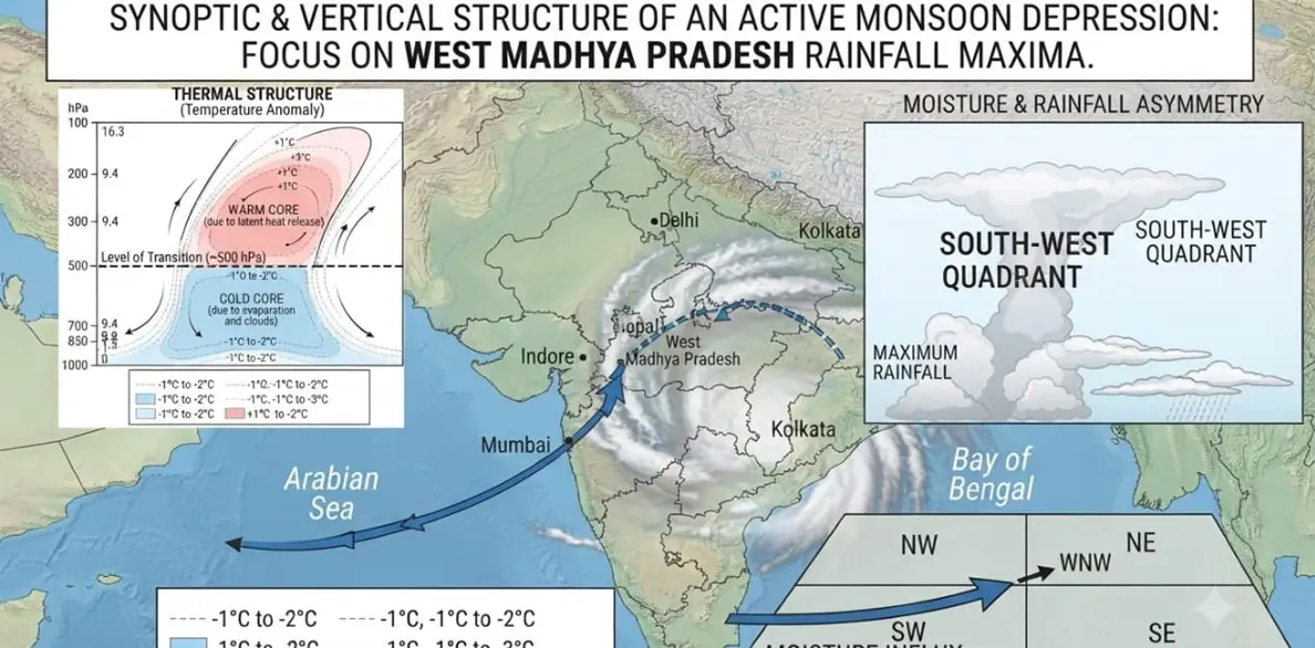
Kerala Weather 06/07/26 : തീവ്ര ന്യൂനമർദ്ദം കരകയറി, കണ്ണൂർ, കാസർകോട് , കോഴിക്കോട് ജില്ലകളിൽ ശക്തമായ മഴ സാധ്യത, കടൽക്ഷോഭം, മത്സ്യബന്ധന വിലക്ക്
മലപ്പുറം (കടലുണ്ടി നഗരം മുതൽ പാലപ്പെട്ടി വരെ), കോഴിക്കോട് (ചോമ്പാല FH മുതൽ രാമനാട്ടുകര വരെ), കണ്ണൂർ, കാസറഗോഡ് (വളപട്ടണം മുതൽ ന്യൂ മഹി വരെയും കുഞ്ചത്തൂർ മുതൽ കോട്ടക്കുന്ന് വരെയും)
06/07/2026 | News desk