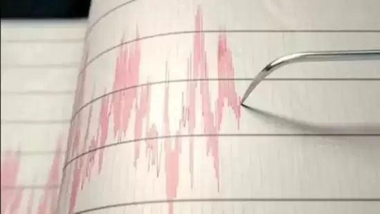
A shallow magnitude 6.2 earthquake was reported in the evening near Gigmoto, Catanduanes, Bicol, Philippines.
According to the United States Geological Survey, the quake hit on Tuesday, April 4th, 2023, at 8:54 pm local time at a shallow depth of 15 km. Shallow earthquakes are felt more strongly than deeper ones as they are closer to the surface. The exact magnitude, epicenter, and depth of the quake might be revised within the next few hours or minutes as seismologists review data and refine their calculations, or as other agencies issue their report.
A second report was later issued by the China Earthquake Networks Center (CEIC), which listed it as a magnitude 6.2 earthquake as well. Other agencies reporting the same quake include Geoscience Australia (GeoAu) at magnitude 6.2, the European-Mediterranean Seismological Centre (EMSC) at magnitude 6.2, the German Research Centre for Geosciences (GFZ) at magnitude 6.3, the German Research Centre for Geosciences (GFZ) at magnitude 6.3, the German Research Centre for Geosciences (GFZ) at magnitude 6.3, Italy’s National Institute of Geophysics and Volcanology (INGV) at magnitude 6.2, the Philippine Institute of Volcanology and Seismology (PHIVOLCS) at magnitude 6.6, France’s Réseau National de Surveillance Sismique (RéNaSS) at magnitude 6.0, and the citizen-seismograph network of RaspberryShake at magnitude 6.2.
Based on the preliminary seismic data, the quake was probably felt by many people in the area of the epicenter. It should not have caused significant damage, other than objects falling from shelves, broken windows, etc.
In Gigmoto (pop. 3,300) located 124 km from the epicenter, Virac (pop. 15,100) 142 km away, and Laoang (pop. 16,700) 143 km away, the quake should have been felt as light shaking.
Earthquake details
Date & time Apr 4, 2023 12:54:32 UTC – 2 hours 23 minutes ago
Local time at epicenter Tuesday, Apr 4, 2023 at 8:54 pm (GMT +8)
Status Confirmed
Magnitude 6.2
Depth 15.0 km
Epicenter latitude / longitude 13.7533°N / 125.5404°E (Philippine Sea, Philippines)
Antipode 13.753°S / 54.46°W
Shaking intensity Light shaking
Felt 44 reports
Primary data source USGS (United States Geological Survey)
Nearest volcano Pocdol Mountains (188 km / 117 mi)
Nearby towns and cities 124 km (77 mi) E of Gigmoto (pop: 3,260) | Show on map | Quakes nearby
142 km (88 mi) E of Virac (Catanduanes) (pop: 15,100) | Show on map | Quakes nearby
143 km (89 mi) NNE of Laoang (Northern Samar) (pop: 16,700) | Show on map | Quakes nearby
170 km (106 mi) NE of Catarman (pop: 47,400) | Show on map | Quakes nearby
189 km (117 mi) ENE of Sorsogon (pop: 82,700) | Show on map | Quakes nearby
206 km (128 mi) ENE of Legazpi (pop: 179,500) | Show on map | Quakes nearby
214 km (133 mi) NNE of Calbayog City (pop: 67,900) | Show on map | Quakes nearby
501 km (311 mi) E of Manila (pop: 1,600,000) | Show on map | Quakes nearby
210 km (130 mi) NNE of Samar Island (pop: 1,751,300) | Show on map | Quakes nearby
440 km (273 mi) NE of Panay Island (pop: 4,307,000) | Show on map | Quakes nearby
Weather at epicenter at time of quake Scattered Clouds 27.2°C (81 F), humidity: 58%, wind: 6 m/s (11 kts) from NE
Estimated seismic energy released 1.3 x 10¹⁴ joules (35 gigawatt hours, equivalent to 30089 tons of TNT or 1.9 atomic bombs!) | about seismic energy
exacyl sans ordonnance: PharmaDirecte – pharmacie en ligne viagra sans ordonnance
http://snabbapoteket.com/# oximeter apotek
utslag bilder: SnabbApoteket – forskolin apotek
apotek lГёrdag: hydrokinon apotek – bakteriell vagose apotek
https://zorgpakket.com/# apotheek inloggen
mina revept melatonin 10 mg apotek pulver vax hГҐr
http://zorgpakket.com/# medicijnen bestellen
kolla blodvГ¤rde apotek: mГ¤ta kolesterol apotek – medicin online
holland apotheke: medicijn – huisapotheek online
http://zorgpakket.com/# onl8ne drogist
medicij MedicijnPunt medicatie online bestellen
apot: sjukhuset apotek – snarkskena apotek
http://snabbapoteket.com/# iodine köpa
covid hjemmetest apotek: fotkrem apotek – ansiktskrem apotek
beställa medicin på nätet SnabbApoteket apotek finland leverans sverige
peroxid apotek: Snabb Apoteket – drick yoghurt
https://snabbapoteket.com/# apotek öppet söndag
tannbleking hjemme apotek: svart hvitlГёk apotek – multivitamin apotek
http://tryggmed.com/# glukosamin apotek
http://zorgpakket.com/# recept medicijn
apotek fri frakt: apotek Г¶ppet sГ¶ndagar – mjГ¶lksyrabakterier tabletter
solariumsbriller apotek apotek koronatest ginkgo biloba apotek
https://zorgpakket.shop/# bestellen medicijnen
sykepleier jobb apotek: TryggMed – apotek storsenter
krem mot pigmentflekker apotek: spypose apotek – nattkjole ull apotek
apotek login SnabbApoteket apotek Г¶ppet 24/7
http://tryggmed.com/# apotek gaver
gabapentin mexican pharmacy: MediMexicoRx – trusted mexican pharmacy
https://indiamedshub.com/# reputable indian pharmacies
tadalafil mexico pharmacy: MediMexicoRx – best prices on finasteride in mexico
buy antibiotics over the counter in mexico buy propecia mexico mexico pharmacy
https://medimexicorx.shop/# buying prescription drugs in mexico online
IndiaMedsHub: indian pharmacy – IndiaMedsHub
http://indiamedshub.com/# best india pharmacy
ExpressCareRx ExpressCareRx concerta pharmacy prices
MediMexicoRx: viagra pills from mexico – gabapentin mexican pharmacy
https://indiamedshub.com/# best india pharmacy
mail order pharmacy india: best india pharmacy – indian pharmacy online
https://medimexicorx.com/# mexican border pharmacies shipping to usa