kerala weather 11/07/25 : ഇന്നു രാത്രി മുതൽ മഴയിൽ വർദ്ധനവ്
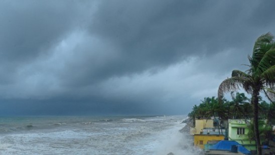
kerala weather 11/07/25 : ഇന്നു രാത്രി മുതൽ മഴയിൽ വർദ്ധനവ് കേരളത്തിൽ ഇന്നു രാത്രി മുതൽ മഴയിൽ വർദ്ധനവ് പ്രതീക്ഷിക്കാം. ഉച്ചക്ക് ശേഷവും വൈകിട്ടും രാത്രിയുമായി …
kerala weather 11/07/25 : ഇന്നു രാത്രി മുതൽ മഴയിൽ വർദ്ധനവ് കേരളത്തിൽ ഇന്നു രാത്രി മുതൽ മഴയിൽ വർദ്ധനവ് പ്രതീക്ഷിക്കാം. ഉച്ചക്ക് ശേഷവും വൈകിട്ടും രാത്രിയുമായി …
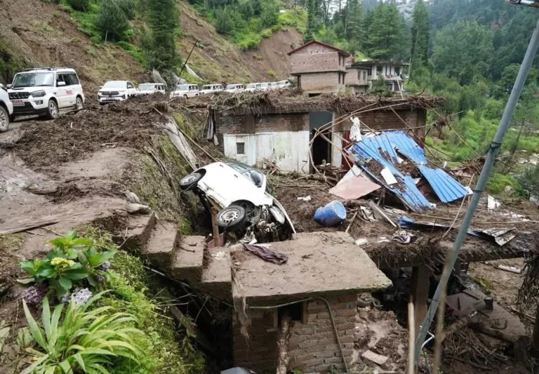
കാലവര്ഷക്കെടുതി: കേരളം ഉള്പ്പെടെ ആറു സംസ്ഥാനങ്ങള്ക്ക് 1,066.80 കോടി രൂപയുടെ കേന്ദ്ര സഹായം കാലവര്ഷക്കെടുതിയും പ്രളയത്തെയും തുടര്ന്ന് കേരളം ഉള്പ്പെടെ ആറു സംസ്ഥാനങ്ങള്ക്ക് കേന്ദ്ര സര്ക്കാര് 1,066.80 …
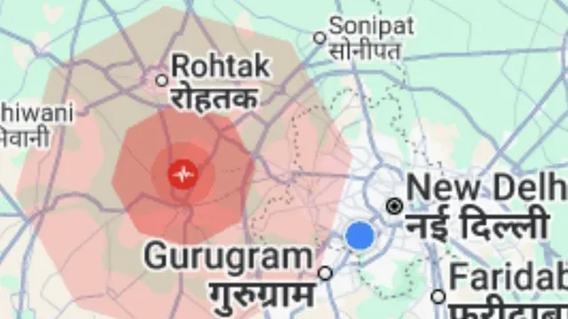
ഹരിയാനയിൽ ഇടത്തരം ഭൂചലനം; ഡൽഹിയിലും അയൽ സംസ്ഥാനങ്ങളിലും അനുഭവപ്പെട്ടു ഇന്ന് രാവിലെ ഹരിയാനയിൽ 4.5 തീവ്രതയുള്ള ഭൂചലനം രേഖപ്പെടുത്തി. ഡൽഹിയിലും തലസ്ഥാന ഭരണ പ്രദേശങ്ങളിലും ഭൂചലനത്തിന്റെ പ്രകമ്പനം …

After 12 years, large sardines are available on the Kerala coast, prices come down, due to climate change After a …

weather kerala 07/07/25: വീണ്ടും കനത്ത മഴ വരുന്നു, ഇന്നത്തെ മഴ സാധ്യത കേരളത്തില് വീണ്ടും കനത്ത മഴ വരുന്നു. ജൂലൈ 12 ഓടെ മഴ സംസ്ഥാന …

ടെക്സസിൽ മിന്നൽ പ്രളയം ; 13 പേർ മരിച്ചു, 23 കുട്ടികളെ കാണാതായി അമേരിക്കയിൽ മുന്നിൽ മിന്നൽ പ്രളയത്തിൽ 13 പേർ മരിച്ചു. 23 പെൺകുട്ടികളെ കാണാതായി. …