Heavy Rain to decrease In Kerala; forecast for next week other states
Heavy Rain to decrease in North Kerala, the off shore monsoon trough from kerala coast to Gujarat is likely to become weaker and hence the rains are likely to decrease according to latest Data.
Expect isolated rains in eastern pockets of Kannur, Kozhikode and Wayanad on 2nd and 3rd August.
But on 4th August pockets like Nedumkadam, Kattapana and certain eastern pockets in Idukki and Pathanamthitta districts could get isolated heavy rains accompanied by thunder & lightning due to easterly anomalies.
In the previous week ended at 23.59 hrs on 1st August 2024, the south west monsoon remained extremely vigorous over north Kerala, eastern parts of Kerala, the Vidarbha, Saurashtra & Kutch, Gujarat, and & very active over north & south coastal Karnataka sub-Himalayan west Bengal, the windward flanks of the north western Nilgiris in Tamil Nadu , Valparai hills in Coimbatore district.
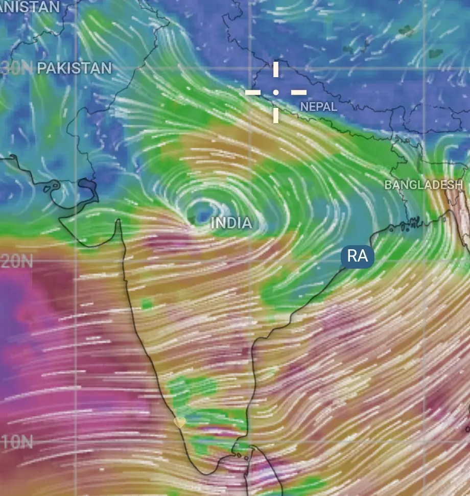
The northern monsoon trough continued to be active and it lay mostly southwards of it normal mean position tilting with height at its south- east extremity into the Bay.
Wayanad Landslide
A spike in the rains was projected on 28th and 29th July for the Malabar region of Kerala and certain eastern pockets particularly Wayanad, with an alert against episodic rains, due to the westward movement of the monsoon depression that developed on 25th night over the Bay of Bengal. But the abrupt change of the behaviour of the rains on 29th needs to be analysed in depth.
It must be borne in mind that even modern NWP (numerical weather predictions) models deploying state- of- the-art AI tools can only project with 75-80% accuracy about a mesoscale system developing within a short span of less than 10 hrs. The usual tools of the trade are not enough to deal with the kind of atmospheric dynamics that comes in the wake of monsoon depressions.
This kind of mesoscale rogue rains covering around 200 sqkms can never come usually from lower level monsoon westerlies as there are no predisposing factors for abrupt vertical expansion of the clouds. In my view there could have been some easterly anomalies that may have got into lower westerlies, causing a sort of convective instability at upper levels causing the clouds to expand vertically with the resultant latent heat flux feeding the system further.
Another unusual thing was that this monsoon depression instead of normally decaying in 4-5 days as it reaches western Madhya Pradesh, contrary to my expectation moved into northern Arabian sea and energised the already active offshore monsoon trough. This along with an unknown easterly anomaly may have caused this extreme rains in Wayanad.
Another possibility could be that the upper level tropical easterly jet which normally moves at 150 hpa( around 10-12 kms from sea level) moved to lower levels setting up massive shear vorticity and upper level divergence or wholesale advection of more moisture from Arabian sea which has already witnessed it’s warmest period.The tropical easterly jet core lies between 15°N and 5°N between Chennai and Thiruvananthapuram during July- August.
In the case of Wayanad, certain private watershed management agencies have in fact been keeping tabs on the daily rainfall data and passing on such data to the district authorities. When a whopping 80 cms of rain falling within a space of less than just 5 days in a small area that should definitely raise a red- flag for the authorities.
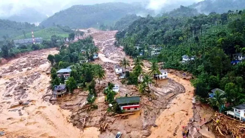
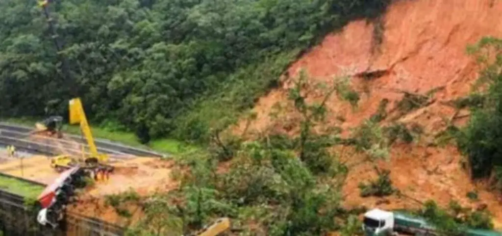
A mini landslide covering 100mx50m height x25m depth of earth itself can easily displace around 1.25 lakhM³ of slush, muck and rock down the line with an acceleration due to gravity of 9.8m/s². The force generated is just unimaginable. Just last week see what havoc a 170mx40x20m landslide at Shirur triggered .The runout ended up almost at the other end of the Gangavali river leaving no trace of people vehicles, and houses in its way.
Just go through all the previous major landslides like Pettimudi, Puthumala . All are nearly lone peaks, facilitating easy vertical orographic lift when there is convective instability. Hence runout zonation to be done on all windward cliffs and around 2-5 sq kms of immediate watershed areas overlooking drop angles less than 30 degrees and these areas are to be strictly to be a no-man zone.
What is needed is restrict human activities in such slide prone areas. That is the only solution. But there is no one- size -fits all cut and dried method which normally govt officials resort to. Runout mapping as I mentioned has to be more realistic. Let the IITs be roped in to study all these high risk-prone areas.
Naturally any excess rains going beyond 30- 40% of the LPA and that too in far lesser time has to be red-flagged. The officials just issue a blanket ban without the guidance of a proper risk prone dynamic runout mapping on a daily basis. It is pointless to simply depend on a historical map of risk prone areas. What is needed is a more realistically drawn up dynamic map based on immediate ground realities.
I still hold a strong hunch that if these relevant statistics and daily rainfall inputs had been sized up on merits , probably , we could have averted the loss of some lives. A Wayanad which had been limping in deficit rains till June 20th suddenly started logging copious rains with alarming frequency and it felt almost as if it was racing to make up for its shortfall in far lesser time.
Isn’t that enough to raise a red flag? In Kerala, with the unprecedented rains between 28th & 30th July 2024, in Malabar area , the rainfall deficit has been wiped out.
Forecast: (Effective from 06:00 hrs from. 02/08/24, to 23:59 hrs on 08/08/24
The northern monsoon trough is likely to remain in its normsl position for 4-5 days more. Once again a fresh monsoon depression is likely to develop around 2nd August over the head of Bay of Bengal . This would trigger extremely heavy rainfall over most areas in gangetic west Bengal, Jharkhand, east Uttarpradesh, Uttrakhand, Himachal Pradesh, NCR Delhi, Chattisgarh, west Madhya Pradesh, south Rajasthan and in eastern Gujarat between 5th and 7th August 2024.
New Delhi, and adjoining parts of Haryana, and Dehradun, Mussourie should expect extremely heavy rains from 6th to 8th August.
Parts of gangetic west Bengal including Kolkotta, sub- himalayan west Bengal, Sikkim, Prayagraj, Lucknow, Kanpur, Dhanbad, Rourkela, Jamshedpur, Raipur , Korba, Bhopal, Jabalpur, Gwalior, Kota, Jodhpur , Udaipur may expect very heavy rains between 2nd and 4th August as the monsoon depression moves westward.
The hill ststions of Uttrakhand and Himachal Pradesh particularly to be on high alert between 6th and 7th August for extremely heavy rains. Hikers snd holidayers planning to travel the hills may better put off their plans as massive landslides and heavy rains are likely on these 2 days.
In the western parts the offshore monsoon trough may remain active from Gujarat to south coastal Karnataka . As a result most of coastal Maharashtra and coastal Konkan & Goa, coastal Karnataka would receive moderate to heavy rains .
In the eastern regions, including the north- east, heavy rains are likely from August 4th to 7th.
Tamilnadu Rain
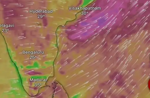
In Tamil Nadu too scattered heavy thundershowers may be expected on 4th and 5th August in pockets like the Nilgiris, Valparsi hills, Puducherry, Pudukkottai, Permbalur, Neyveli, Thiruvannamalai, Tiruvarur, Salem, Theni, Dindigul , Sivagangai, Madhurai, Rajapalaiyam and Tenkasi due to wind convergence and easterly anomalies.
Heavy rainfall alerts for States
North west India:
New Delhi, Panipat, Karnal, Chandigarh , Patiala, Ludhiana, Gurudaspur, Jodhpur and Udaipur between 2nd and 4th August and between 6th & 7th August.
Uttrakhand & Himachal Pradesh:
Mandi, Manali, Shimla, Rampur, Kasol, Uttarkashi, Dehradun, Mussourie, Pauri- Gharwal, Chamoli, Karnaprayaga between 5th and 7th August.
Madhya Pradesh
Gwalior, Indore, Bhopal, Itarsi, Jabalpur, Nainpur, Kota, and Sagar on 3rd and 4th August.
Gujarat
Nadiad, Bhavnagar, Suret, Ahmedabad, Dahod and Vadodara between 3rd & 4th August.
Maharashtra & Goa
Ratnagiri, Panaji, Nashik, Kolhapur, Jalgaon, Mahabaleswar, Lonawala, Goregaon between 3rd and 4th August.
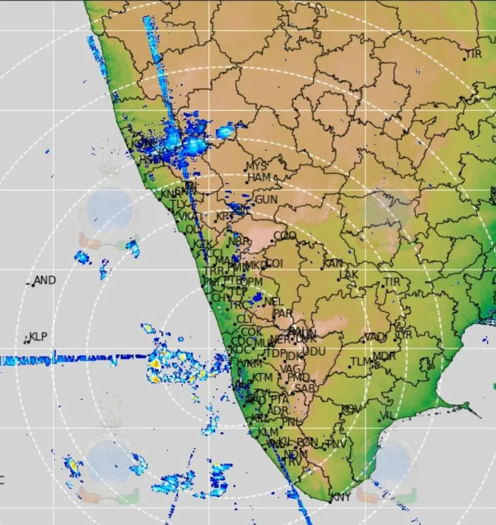
Karnataka
Karwar, Mangalore, Honavar , Uduppi and Bhatkal and Coorg between 3rd and 4th August.
Tamilnadu
Dindigul, Kovilpatti, Sikazhi, Kancheepuram, Perambalur, Kodumudi, Kallaikurchi on 4th August.
KERALA
There is no specific alert for any extreme heavy rainfall events for Kerala in the upcoming week.
In the Wayanad lanslide- prone areas , moderate rains may occur on 3rd, 7th and 8th August. However, isolated heavy rains may occur over Alapuzha, Chengannur, and eastern parts of of Kottayam, on 2nd August and pockets like Nedumkandam, Kattappana, Udumbanchola Painavu, Sabari hills, Peerumade, and adjoining areas on 4th and 5th August.
follow us in