Heavy rains in Oman likely as cyclone intensifies
Tropical Cyclone ‘Tej’ in the Arabian Sea has developed into a second-degree tropical cyclone and is likely to make a landfall between Oman and Yemen on October 25, reports said.

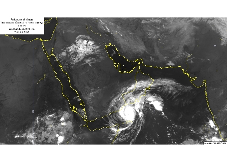
According to Oman Meteorology, the cyclone deepened into a second-degree tropical cyclone, with wind speeds around its center ranging between 83 and 95 knots. It is still centered southwest of the Arabian Sea at latitude 12.17 north and longitude 55.54 east.
Its movement continues west/northwest with rain clouds extending over the coastal areas of Dhofar and Al Wusta Governorates, said a Times of Oman report.
The impact of the cyclone is expected to begin at Dhofar and Al Wusta Governorates starting from Sunday night (October 22) with heavy rainfall (50-150) mm forecast, Oman Meteorology said.
The forecasts suggest that Tej is likely to further intensify into a category 4 cyclone within the next 24 hours. The most impact is expected to be on Monday and Tuesday with extremely heavy rainfall (200-500 mm) which will cause flashfloods and moderate to fresh winds (40-70 knots) with strong gusts which may lead to the falling of trees.