weather 27/09/24 : CC to form near Sri lanka, intense rain expected in kerala
As Metbeat Weather forecasted early intense rain expected onece more in kerala due to upcoming cyclonic circulation (CC) over Srilanka month end.
Another upper air circulation (UAC) is likely over south east Sri Lanka around 27th September. Under its influence easterly anomalies and a north – south shear zone running from north interior Maharashtra to south Tamilnadu through interior Karnataka around may cause widespread heavy thunder showers over south and central Tamilnadu and eastern pockets of Kerala from 28th to 1st October.
In the previous week ended at 23.59 hrs on 26th September 2024, the south-west monsoon is on its retreat mode. It has withdrawn mostly from the north western regions comprising Rajasthan, north- western parts of Gujarat . Conditions are becoming favourable for the further retreat of monsoon from Punjab ,Haryana , J&K, NCR Delhi, in the next 3&4 days as the north western heat low has started dissipating.
The monsoon trough has been tilted more south of its mean position at its north- west end and remained south of its normal at its south-east end. The western offshore trough has further weakened from Gujarat to the Malabar coast.
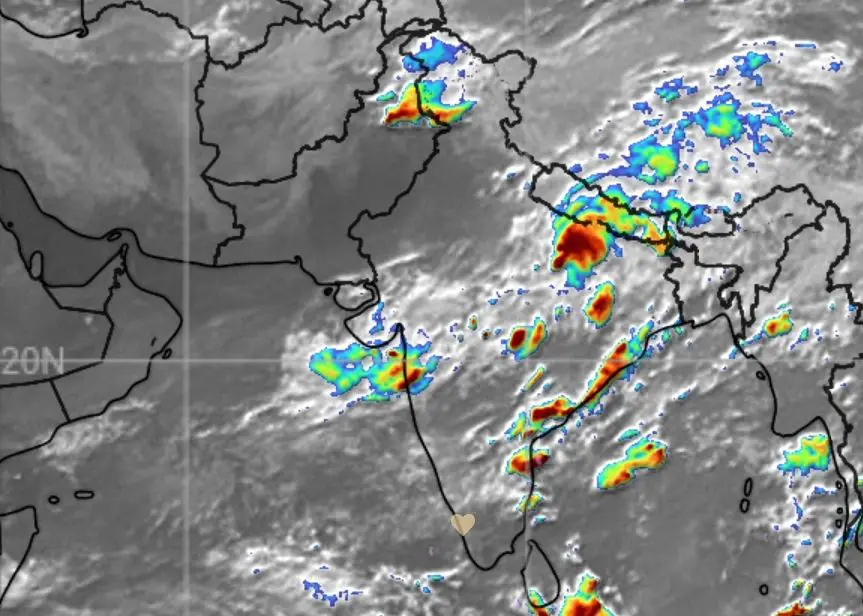
Meanwhile under the influence of the large scale synoptic upper air circulation and associated trough at middle and lower levels, heavy rains have been recorded over many places in gangetic west Bengal, Odisha, Jharkhand, Chattisgarh, east Uttar Pradesh. Another mid tropospheric low over north Arabian sea off the Mumbai coast caused widespread heavy rains along coastal Maharashtra, Konkan & Goa, besides pockets like Bhavnagar, Surat, gulf of Khambat in south coastal Gujarat and central Gujarat. Regions over east Madhya Pradesh, west Madhya Pradesh, and Vidarbha regions too recorded moderate to heavy rains.
In the north east, rainfal has been fairly active over sub- Himalayan west Bengal, west Bengal, upper Assam, Arunachal Pradesh, Meghalaya. In the south, impressive rainfall activity occurred over Telengana, north interior Karnataka & Marathwada. As the western monsoon offshore trough has been weak, only scattered rainfall occurred over Kerala.
Due to trough in the easterlies and wind discontinuity, isolated heavy rains occurred over north and central Tamil Nadu. With the autumn equinox falling on 22st September, coinciding with apparent transit of the Sun to the equator, intense heat has been experienced in central and south interior Tamilnadu. The highest day temperature over the country has been recorded at Madhurai at 41°C on September 25th.
Forecast: Effective from 06:00 hrs from. 27/09/24, to 23:59 hrs on 03/10/24.
The northern monsoon trough would continue to shift southward and dissipate as the north western heat low has lost steam. The large-scale upper air circulation over central India and the associated synoptic features is now favourable for heavy rains over most parts of Jharkhand, Bihar, east Uttar Pradesh from 27th to 29 th September.
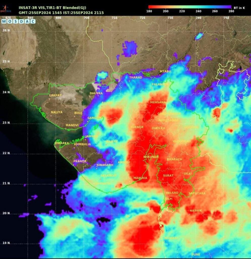
Another mid tropospheric low off the Gujarat coast and and east-west shear zone from Gujarat to Jharkhand could trigger very heavy rains over south coastal Gujarat including areas around the Gulf of Khambat on 27 th 28 th & 29 th September.
A line of wind discontinuity and east – west shear zone may lie from north interior Maharashtra to sub- Himalayan west Bengal around 2nd October. An upper air circulation may lie over Assam and adjoining areas of Arunachal Pradesh from 1st October to 3 rd October.
Under its influence widespread thundershowers or rainfall activity is likely over Jharkhand , Odisha, coastal Andhra Pradesh, Telengana , north and south interior Karnataka, gangetic west Bengal, sub-Himalayan west Bengal, Assam & Meghalaya , on 2nd October.
The North east , Uttrakhand , Uttar Pradesh, Bihar, Jharkhand , gangetic west Bengal, regions .
Under the influence of the mid tropospheric cyclonic circulation moderate to heavy rains or thundershowers may be expected in Meghalaya , upper Assam, sub-Himalayan west Bengal, gangetic west Bengal, east Uttar Pradesh, Jharkhand and Bihar on 27 th and 28 th September.
Western, eastern,central and south India
The western offshore trough, is almost dissipated or showing nil activity . However , an upper air cyclonic circulation over south coastal Gujarat may result in very heavy rains over coastal and interior pockets of Gujarat, north coastal Maharashtra and pockets like Palghar, Nashik, Igatpuri , Kalyan Dombivali Virar, Vasai and pockets in north coastal Karnataka from 27 th to 28 th September .
Kerala, Karnataka and Tamil Nadu regions
The western offshore trough may be weak or absent over the Kerala coast . However due to the north-south shear zone extending from interior Karnataka to south interior Tamil Nadu through Kerala, isolated moderate to heavy rains may be expected over the eastern pockets of Kannur, Kozhikode, Wayanad, Malappuram Palakkad, Idukki , Kottayam and Pathanamthitta on 29 th September. Isolated thunder showers are also likely over south interior Karnataka on 29th September.
In the central and southern interior pockets of Tamil Nadu, due to the shear zone extending from north interior Karnataka to south Tamil Nadu, isolated thundershowers may be expected in pockets like Salem, Erode, Namakkal Trichy, Madhurai, Bodi, Theni, Madhurai, Dindigul , Peraiyur, and Arappukkottai on 28th and 29 th September.
General distribution of rainfall and pockets of heavy rainfall alerts for the upcoming week:
North west India:
Nil
North- East India ( moderate to heavy )
Meghalaya, sub- Himalayan west Bengal Imphal, Aizwal, upper Assam, Silchar, Jorhat, Guwahati on 28th September & 2nd October 2024.
Uttrakhand & Himachal Pradesh:
Nil
Bihar & Jharkhand
27 th &28 th September
Uttar Pradesh:( Moderate to heavy)
Bareilly, Faizabad, Agra, Jhansi , Kanpur ,Prayagraj, Varanasi, Jhansi on 27th and 28th September.
Madhya Pradesh: Nil
Gujarat: (Moderate to very heavy)
Surat, Valsad, Veraval , Bhavnagar, Ahmedabad , and Vadodara on 27th and 28 th September .
Maharashtra & Goa: ( Heavy to very heavy)
, Jagaon, Malegaon, Nashik, , Mumbai, Dombivali, Dhanau, Palghar on 27th & 28 th September.
Andhra Pradesh & Telengana ( Moderate to very heavy)
Vizag, Kakinada, Viyayawada, Jagadalpur, Warangal, Mehbubnagar , Khammam, Nalgonda on 24 th & 24th September.
Karnataka:( Moderate to heavy)
Hubbali, Hassan, Devanagare, Tumkur, Kunigal, Mysuru and Bengluru on 29 th September.
Tamil nadu: ( moderate to heavy)
Chennai, Thiruvannamalai, Vellore, Neyveli, Salem, Trichy, Erode, Namakkal, Madhurai and Thirunelveli , Kadayam, and Tenkasi on 28 th & 29 th September.
KERALA
There is no specific alert for extreme heavy rainfall events anywhere in Kerala. However, moderate to heavy thundershowers are likely over most of the eastern pockets and high ranges in all the districts on 29 th September. The rains may be heavier in Pathanamthitta, Idukki, eastern pockets of Kozhikode and Palakkad .
SPECIAL WEATHER ALERT FOR TRAVELLERS AND TOURISTS:
North East India:
Darjeeling, Gangtok, Siliguri, Arunachal Pradesh, Shillong Meghalaya likely to be rainy on 27 th & 28 September .
Maximum and minimum temperature: 22°C & 18°C.
Uttrakhand:(Moderate )
Pithoragarh , Champawat and adjoining hill stations on the eastern Himalayas may expect moderate rains on 27th September. Maximum day temperature 25°C and minimum 15°C in lower Himalayas and 10°C and 5°C in the greater Himalayas lying above 2500 metres above MSL.
The Kedarnath and Badrinath hill shrines in the Gharwal Himalayas may expect light rains on 27th September. Maximum day temperature in Kedarnath is likely to be 9°C and minimum -2°C. In Badrinath the maximum day temperature is likely to be 10°C and minimum at -3°C.
The Hemkund Sahib Gurudwara in the Gharwal Himalayas may remain cloudy with very light rain on 27th September. The maximum day temperature may be 10°C and minimum may range from 4°C to minus 2°C .
Himachal Pradesh .
Manali, Shimla, Bilaspur, Mandi , Kangra valley may remain generally dry or with overcast sky. Maximum & minimum temperature:
24°C and 15°C respectively in Shimla and the lower Shivalik ranges and 15°C and 4°C respectively in Manali and the upper Himalayas and Kinnaur ranges.
Jammu& Kashmir :
Generally dry.
Maximum day temperature in the lower Zabarwan ranges of Himalayas comprising Srinagar would be 27° and minimum 14°C. In the upper reaches of Zankar , Pir Panjal and Ladakh ranges the maximum day temperature would be 14°C and minimum 5°C.
South India:
Hillstations of Ooty and Kodaikanal may be pleasant with generally overcast skies. Kodaikanal may expect isolated moderate to heavy thunder showers or rains on 29th rd and 30th September . Maximum and minimum temperature: 20°C and 13°C in Ooty and 24°C and 13°C in Kodaikanal.
In Kerala the main hillstations of Kerala, , Wayanad , Munnar, Devikulam, Vagamon and Peerumade may expect moderate thunder showers rains on 28th September with maximum day temperature at 22°C and minimum at 16°C in Munnar and Devikulam and in other hill stations with maximum at 28°C and minimum at 20 °C. In Kanthalloor , Vattavada regions, the maximum temperature is likely to be in the range 19°C to 22°C and minimum temperature around 13°C to 15°C with chance of light rains on 28/9/24 . The backwaters in Ernakulam , Alappuzha and Kumarakom may expect moderate rains on 29th September.
(NB: Next weekly post on 03/10/24)
https://biotpharm.shop/# buy antibiotics from canada
http://pharmau24.com/# Online drugstore Australia
Ero Pharm Fast: Ero Pharm Fast – Ero Pharm Fast
ed meds online [url=http://eropharmfast.com/#]affordable ed medication[/url] Ero Pharm Fast
boner pills online [url=http://eropharmfast.com/#]ed treatment online[/url] buy ed medication
https://biotpharm.com/# buy antibiotics from canada
ed prescriptions online [url=https://eropharmfast.shop/#]Ero Pharm Fast[/url] ed pills for sale
Medications online Australia [url=https://pharmau24.shop/#]Licensed online pharmacy AU[/url] PharmAu24
Ero Pharm Fast: ed meds online – Ero Pharm Fast
https://eropharmfast.shop/# pills for erectile dysfunction online
low cost ed pills [url=https://eropharmfast.com/#]online prescription for ed[/url] ed meds by mail
Ero Pharm Fast [url=http://eropharmfast.com/#]cheap ed treatment[/url] Ero Pharm Fast
cheap ed pills online: boner pills online – ed online meds
https://pharmau24.shop/# Buy medicine online Australia
cheap ed meds online [url=http://eropharmfast.com/#]ed pills cheap[/url] how to get ed pills
https://ciasansordonnance.com/# pharmacie en ligne france pas cher
Cialis sans ordonnance 24h: Cialis generique sans ordonnance – traitement ED discret en ligne
kamagra oral jelly [url=https://kampascher.com/#]kamagra pas cher[/url] kamagra 100mg prix
prix bas Viagra generique: Viagra sans ordonnance 24h – viagra en ligne
pharmacie en ligne pas cher [url=https://pharmsansordonnance.shop/#]pharmacie en ligne[/url] vente de mГ©dicament en ligne
commander Viagra discretement: Viagra generique en pharmacie – prix bas Viagra generique
acheter medicaments sans ordonnance: Pharmacie en ligne livraison Europe – pharmacie en ligne livraison europe
https://ciasansordonnance.com/# cialis generique
livraison rapide Viagra en France [url=https://viasansordonnance.com/#]viagra sans ordonnance[/url] Viagra generique en pharmacie
Viagra sans ordonnance 24h: Viagra sans ordonnance 24h – viagra sans ordonnance
Pharmacies en ligne certifiees: pharmacie en ligne sans ordonnance – acheter mГ©dicament en ligne sans ordonnance
Pharmacies en ligne certifiees: pharmacie en ligne pas cher – pharmacie en ligne france pas cher
vente de mГ©dicament en ligne [url=https://pharmsansordonnance.shop/#]Medicaments en ligne livres en 24h[/url] pharmacie en ligne sans ordonnance
https://viasansordonnance.com/# Viagra generique en pharmacie
kamagra 100mg prix: livraison discrete Kamagra – kamagra pas cher
Pharmacie en ligne livraison Europe: commander sans consultation medicale – pharmacie en ligne france livraison internationale
cialis prix [url=https://ciasansordonnance.shop/#]cialis sans ordonnance[/url] Acheter Cialis
trouver un mГ©dicament en pharmacie: pharmacie en ligne sans ordonnance – pharmacie en ligne livraison europe
commander Cialis en ligne sans prescription [url=http://ciasansordonnance.com/#]cialis generique[/url] cialis generique
kamagra pas cher: acheter Kamagra sans ordonnance – commander Kamagra en ligne
Cialis generique sans ordonnance [url=https://ciasansordonnance.com/#]traitement ED discret en ligne[/url] commander Cialis en ligne sans prescription
Acheter du Viagra sans ordonnance: viagra sans ordonnance – acheter Viagra sans ordonnance
https://kampascher.com/# Kamagra oral jelly pas cher
achat kamagra [url=http://kampascher.com/#]kamagra pas cher[/url] kamagra oral jelly
pharmacie en ligne sans ordonnance: pharmacie en ligne – pharmacie en ligne
Medicaments en ligne livres en 24h: pharmacie en ligne – pharmacie en ligne sans ordonnance
pharmacie en ligne sans prescription [url=https://pharmsansordonnance.com/#]Pharmacies en ligne certifiees[/url] pharmacie en ligne france fiable
livraison rapide Viagra en France: acheter Viagra sans ordonnance – Meilleur Viagra sans ordonnance 24h
cialis generique: cialis sans ordonnance – Cialis sans ordonnance 24h
http://kampascher.com/# acheter Kamagra sans ordonnance
Viagra generique en pharmacie [url=https://viasansordonnance.com/#]livraison rapide Viagra en France[/url] acheter Viagra sans ordonnance
cialis prix: cialis sans ordonnance – pharmacie en ligne france livraison internationale
Meilleur Viagra sans ordonnance 24h: Viagra generique en pharmacie – Viagra sans ordonnance 24h
cialis sans ordonnance [url=http://ciasansordonnance.com/#]acheter Cialis sans ordonnance[/url] cialis generique
Acheter Cialis: commander Cialis en ligne sans prescription – Cialis pas cher livraison rapide
viagra en ligne: Meilleur Viagra sans ordonnance 24h – acheter Viagra sans ordonnance
https://pharmsansordonnance.shop/# pharmacies en ligne certifiГ©es
pharmacie en ligne sans ordonnance [url=https://pharmsansordonnance.com/#]pharmacie en ligne sans prescription[/url] Achat mГ©dicament en ligne fiable
Acheter Cialis 20 mg pas cher: commander Cialis en ligne sans prescription – traitement ED discret en ligne
kamagra pas cher: acheter mГ©dicament en ligne sans ordonnance – kamagra pas cher
Acheter Cialis [url=https://ciasansordonnance.com/#]commander Cialis en ligne sans prescription[/url] cialis sans ordonnance
livraison rapide Viagra en France: viagra en ligne – acheter Viagra sans ordonnance
Acheter Cialis 20 mg pas cher: commander Cialis en ligne sans prescription – acheter Cialis sans ordonnance
pharmacie en ligne sans prescription [url=https://pharmsansordonnance.shop/#]pharmacie en ligne[/url] pharmacie en ligne france fiable
livraison discrete Kamagra: kamagra 100mg prix – livraison discrete Kamagra
achat kamagra: kamagra en ligne – kamagra pas cher
Viagra pas cher inde [url=https://viasansordonnance.shop/#]livraison rapide Viagra en France[/url] Sildenafil teva 100 mg sans ordonnance
commander Kamagra en ligne: kamagra gel – kamagra oral jelly
kamagra gel: Achat mГ©dicament en ligne fiable – kamagra gel
acheter Kamagra sans ordonnance [url=https://kampascher.com/#]pharmacie en ligne sans ordonnance[/url] acheter kamagra site fiable
cialis sans ordonnance: cialis sans ordonnance – traitement ED discret en ligne
https://kampascher.com/# kamagra gel
Pharmacie Internationale en ligne [url=http://ciasansordonnance.com/#]cialis sans ordonnance[/url] Cialis pas cher livraison rapide
kamagra pas cher: kamagra livraison 24h – kamagra en ligne
pharmacie en ligne: Pharmacies en ligne certifiees – pharmacies en ligne certifiГ©es
commander Kamagra en ligne [url=https://kampascher.com/#]acheter Kamagra sans ordonnance[/url] acheter Kamagra sans ordonnance
http://kampascher.com/# kamagra pas cher
pharmacie en ligne: pharmacie internet fiable France – pharmacie en ligne france pas cher
pharmacie en ligne pas cher: pharmacie en ligne sans prescription – pharmacie en ligne fiable
Viagra sans ordonnance 24h: prix bas Viagra generique – viagra sans ordonnance
https://kampascher.shop/# kamagra 100mg prix
Pharmacies en ligne certifiees [url=https://pharmsansordonnance.com/#]Medicaments en ligne livres en 24h[/url] pharmacie en ligne pas cher
viagra en ligne [url=https://viasansordonnance.com/#]Viagra sans ordonnance 24h[/url] Viagra generique en pharmacie
se puede comprar eutirox sin receta: cytotec se puede comprar sin receta medica – se puede comprar permetrina sin receta
comprar pastilla del dia despues sin receta: Confia Pharma – se puede comprar metadona sin receta
https://pharmacieexpress.shop/# ketum pommade
diprosone lozione prezzo: augmentin bustine – brufecod a cosa serve
seleparina 0 4 [url=http://farmaciasubito.com/#]pulmist aerosol[/url] medrol 4 mg
cortisone al cane: monotest farmacia – sildenafil 25 mg
konakion fiale prezzo: Farmacia Subito – aerius 5 mg prezzo
zolpidem prix pharmacie sans ordonnance [url=http://pharmacieexpress.com/#]diprosone sans ordonnance en pharmacie[/url] cialis gГ©nГ©rique prix
farmacia online guantes desechables: se puede comprar viagra sin receta espaГ±a – farmacia online eua
peux t-on acheter du viagra en pharmacie sans ordonnance: rhumatologue sans ordonnance – zymad sans ordonnance prix
https://pharmacieexpress.shop/# viagra generique en pharmacie sans ordonnance
soldesam 8 mg: bentelan 1 5 mg fiale – farmacia omeopatica online
ibuprofeno se puede comprar sin receta [url=http://confiapharma.com/#]comprar medicamentos on line sin receta[/url] universidad de farmacia online
ovixan crema a cosa serve: vermox sciroppo bambini – olpress 40 mg prezzo
xarenel 50.000 flaconi prezzo: zitromax sciroppo bambini – pasaden gocce
a derma epitheliale ah: Pharmacie Express – homГ©opathie avec ou sans ordonnance
monurol comprar sin receta [url=https://confiapharma.shop/#]Confia Pharma[/url] arbosana farmacia online
https://pharmacieexpress.shop/# acheter la pilule sans ordonnance en pharmacie
diprosalic lozione prezzo: cefixoral 400 mg prezzo – airol lozione vendita online
se puede comprar famciclovir sin receta [url=http://confiapharma.com/#]farmacia santa lucГa online[/url] cloretilo se puede comprar sin receta
resilient 83 mg prezzo: vimovo prezzo – songar gocce prezzo
top farmacia ordini online: Farmacia Subito – vigorsol cult che fine hanno fatto
ciclolux collirio prezzo: yasminelle pillola prezzo – sonirem gocce prezzo
a derma epitheliale duo [url=http://pharmacieexpress.com/#]que peut on acheter en pharmacie sans ordonnance[/url] quelle pommade antibiotique sans ordonnance ?
https://pharmacieexpress.com/# acheter selincro en ligne sans ordonnance
caudalie shampoing: achat cialis – cialis achat pharmacie en ligne
galastop prezzo: minias principio attivo – pillola effiprev
cynomel t3 en pharmacie sans ordonnance [url=http://pharmacieexpress.com/#]acheter viagra gГ©nГ©rique[/url] test urinaire sans ordonnance
antibiotique pour infection urinaire sans ordonnance: acheter augmentin sans ordonnance – anxemil sans ordonnance
huile gomenolee sans ordonnance: Pharmacie Express – ivermectine pharmacie sans ordonnance
viagra generique achat [url=https://pharmacieexpress.com/#]Pharmacie Express[/url] finasteride gel
https://pharmacieexpress.com/# quel est le meilleur antidГ©presseur sans ordonnance ?
farmacia leon online: comprar eq zona sin receta – comprar vitamina d sin receta
farmacia rovira online: farmacia online promociones – puedo comprar semaglutida sin receta
farmacia online 24 [url=https://confiapharma.com/#]puedo comprar metformina sin receta[/url] se puede comprar ciclofalina sin receta
crГЁme zensa pharmacie sans ordonnance: que peut on acheter en pharmacie sans ordonnance – pharmacie en ligne medicament sans ordonnance
l’amoxicilline sans ordonnance: Pharmacie Express – acheter viagra pharmacie sans ordonnance
betmiga 50 mg prezzo [url=http://farmaciasubito.com/#]Farmacia Subito[/url] bivis 20/5 prezzo
demande ordonnance en ligne: Pharmacie Express – contraception pharmacie sans ordonnance
viagra prix: spedra prix – commander viagra
http://confiapharma.com/# la farmacia online castro urdiales
se puede comprar salbutamol sin receta en espaГ±a [url=https://confiapharma.shop/#]se pueden comprar antibioticos sin receta en espaГ±a[/url] comprar litio sin receta
soldesam punture: farmaci per aumentare le difese immunitarie – folifill 5 mg prezzo
keppra 1000: Farmacia Subito – come far prendere l’antibiotico ai bambini
pedir online farmacia: farmacia online dosfarma – farmacia online test ovulacion
farmacia online cГіrdoba [url=https://confiapharma.shop/#]terfamex donde comprar sin receta[/url] se puede comprar pastillas para dormir sin receta
farmacia romania online: Farmacia Subito – eutirox 25 mg
puedo comprar clindamicina sin receta: elvenir comprar sin receta – que farmacia online es mas barata
https://confiapharma.shop/# farmacia online trieste
lyrica prezzo 25 mg: giant 20/5 mg prezzo – tadalafil 20 mg prezzo
deflan 6 mg a cosa serve [url=https://farmaciasubito.com/#]ibuprofene 600 bustine[/url] glicole propilenico farmacia online
onguent antibiotique sans ordonnance: pharmacie zemiro – amoxicilline sans ordonnance prix
emortrofine crema: sirdalud 2 mg prezzo mutuabile – farmacia online affidabile
brosse Г dent gum ortho [url=http://pharmacieexpress.com/#]ordonnance francaise en belgique[/url] exemple ordonnance ventoline
donde puedo comprar viagra sin receta en farmacias: comprar viagra sin receta foro – como comprar sildenafil sin receta
https://farmaciasubito.shop/# debridat compresse prezzo
kijimea stomaco irritabile: fexallegra prezzo – tranex 500 fiale per bocca
puedo comprar las pastillas para dejar de fumar sin receta [url=https://confiapharma.shop/#]comprar on line rohipnol 2mg sin receta mГ©dica[/url] analgilasa comprar sin receta
mycostatin comprar sin receta: farmacia online para mascotas – donde comprar medicamentos sin receta en orlando
mГ©latonine en pharmacie sans ordonnance: bioderma anti rougeur – ozempic ordonnance
ovixan crema punture insetti [url=http://farmaciasubito.com/#]Farmacia Subito[/url] cortisone cani
farmacia de sevilla online: capitulos farmacia de guardia online – farmacia torrent andorra online
kyleena spirale prezzo: miglior farmacia online 2022 – farmacia veterinaria online
https://confiapharma.com/# farmacia online cruz verde
farmacia online piu affidabile [url=https://farmaciasubito.com/#]travosept crema prezzo[/url] shop farmacia online
donde comprar valium sin receta: farmacia veterinaria online chile – ley farmacia online
tript oh: atenololo 50 mg prezzo – galastop prezzo
puedo comprar ketorolaco sin receta [url=http://confiapharma.com/#]Confia Pharma[/url] farmacia online gibraltar
http://pharmexpress24.com/# rx pharmacy richland washington
reputable online pharmacy uk: Pharm Express 24 – percocet mexico pharmacy
reliable online pharmacy viagra [url=https://pharmexpress24.shop/#]mexican pharmacy[/url] value rx pharmacy irvine
order xanax from mexico: nurtec in mexico – what to buy mexican pharmacy
https://pharmexpress24.shop/# hq pharmacy online 365
pharmacy online degrees: Pharm Express 24 – rx pharmacy charlotte nc
online pharmacy glucophage [url=http://pharmexpress24.com/#]circle rx pharmacy[/url] pharmacie canadienne
unicare pharmacy artane: priligy malaysia pharmacy – global rx pharmacy irvine
medication in mexico: mounjaro in mexico – cheapest mail order pharmacy
rx to go pharmacy: apollo pharmacy online – legal online pharmacy coupon code
b pharmacy fees in india [url=http://inpharm24.com/#]buy medication from india[/url] best indian pharmacy
https://pharmmex.com/# cost of prednisone in mexico
india pharmacy ship to usa: india online pharmacy market – online pharmacy app developer in india
can you buy vicodin in mexico: Pharm Mex – buy mounjaro from mexico
doxepin pharmacy: online pharmacy worldwide shipping – abilify pharmacy assistance
drugs from india [url=https://inpharm24.shop/#]InPharm24[/url] india prescription drugs
overseas pharmacies: peoples pharmacy austin store hours – Florinef
hydroxyzine online pharmacy: zithromax online pharmacy – oxymorphone online pharmacy
http://pharmexpress24.com/# auto rx pharmacy
tramadol in mexico [url=http://pharmmex.com/#]Pharm Mex[/url] medicine land pharmacy
ed medication: erectile dysfunction causes – AebgJoymn
buy medicines online with discount: mexican pain relief cream – mexican pharmacy phentermine
mexico meds: Pharm Mex – order pills
b pharmacy fees in india [url=https://inpharm24.shop/#]india mail order pharmacy[/url] pharmacy from india
list of pharmacies in india: india pharmacy of the world – e pharmacy india
indian pharmacies: b pharmacy salary in india – buy medicine from india
best online pharmacy clomid: amar pharmacy rx – amoxicillin uk pharmacy
http://pharmmex.com/# gabapentin mexico over the counter
mexican pharmacy ritalin [url=http://pharmmex.com/#]trusted fill pharmacy[/url] legit online mexican pharmacy
tijuana pharmacy online: Pharm Mex – how to get a prescription in mexico
buy viagra in mexico: is ozempic otc in mexico – pharmacies in tijuana mexico
cialis super active online pharmacy: what’s the best online pharmacy – fry’s pharmacy
publix pharmacy cipro: Pharm Express 24 – india pharmacy
mexican water pills [url=https://pharmmex.com/#]tramadol from mexico to us[/url] how much is mounjaro in mexico
buying pain meds in mexico: international drug store – mounjaro mexico cost
https://inpharm24.com/# pharmacy india online
mexican pharmacy reviews: Pharm Mex – can i order prescription drugs online
pharmacy education in india: ivermectin india pharmacy – india online pharmacy market
diplomat pharmacy lipitor: online pharmacies – b12 injections online pharmacy
pharmacy education in india [url=http://inpharm24.com/#]compounding pharmacy in india[/url] india drug store
online pharmacy generic viagra: allergy – percocet cost pharmacy
http://pharmexpress24.com/# weis pharmacy
pharmacy store online [url=https://pharmmex.com/#]Pharm Mex[/url] mexican pharmacy doctor mascot
online pharmacy in india: medicine from india – best online pharmacy india
can you buy prednisone in mexico: Pharm Mex – pharmacies in mexico
sildenafil in mexico: VGR Sources – female viagra pills online
buy viagra 100 [url=https://vgrsources.com/#]VGR Sources[/url] sildenafil 100mg generic mexico
https://vgrsources.com/# real viagra no prescription
sildenafil generic otc: female viagra 18 – lowest price generic viagra
where to get women viagra: VGR Sources – cheap viagra pills usa
viagra online store: female viagra drug – viagra tablets
online viagra canadian pharmacy online [url=https://vgrsources.com/#]where to get viagra in usa[/url] real viagra without a prescription
https://vgrsources.com/# where to buy sildenafil
buy female viagra pills in india online: VGR Sources – viagra 25mg online india
pharmacy viagra uk: VGR Sources – viagra best price usa
sildenafil 1000 mg [url=https://vgrsources.com/#]VGR Sources[/url] sildenafil canada
generic viagra online pharmacy india: VGR Sources – generic sildenafil usa
viagra generic 20 mg: VGR Sources – can i buy viagra online with paypal
female viagra otc [url=https://vgrsources.com/#]VGR Sources[/url] where to get over the counter viagra
https://vgrsources.com/# sildenafil price 50 mg
cheapest price for generic viagra: VGR Sources – viagra pills price in india
buy viagra 200mg online [url=https://vgrsources.com/#]sildenafil tabs 20mg[/url] viagra over the counter in usa
where can i buy female viagra in india: viagra 100mg online in india – female viagra without prescription
sildenafil 50: VGR Sources – how to buy viagra online canada
online generic viagra prescription [url=https://vgrsources.com/#]VGR Sources[/url] order viagra cheap online
online pharmacy uk viagra: buy viagra with mastercard – canadian pharmacy viagra 100 mg
https://vgrsources.com/# order generic viagra uk
where can i buy viagra over the counter usa [url=https://vgrsources.com/#]VGR Sources[/url] buy viagra online fast shipping
cost of generic viagra in india: buy women viagra online – viagra pills online for sale
mail order viagra canada: VGR Sources – genuine viagra pills
purchase viagra no prescription [url=https://vgrsources.com/#]VGR Sources[/url] viagra price in canada
cheap discount viagra: VGR Sources – viagra pills price in south africa
sildenafil cost 100mg: VGR Sources – viagra for female for sale
https://vgrsources.com/# sildenafil pills for sale
viagra online pfizer [url=https://vgrsources.com/#]brand viagra online[/url] viagra 100mg online australia
415 viagra 4: online viagra paypal – viagra generic canada price
otc viagra usa: VGR Sources – viagra soft tabs 100mg pills
viagra 4 pack: VGR Sources – viagra in canada cost
https://vgrsources.com/# sildenafil 100mg tablets
generic viagra soft tab [url=https://vgrsources.com/#]VGR Sources[/url] viagra online sales
viagra 100 mg price in india: viagra suppliers – pill viagra
where to buy real viagra cheap [url=https://vgrsources.com/#]sildenafil tablets online in india[/url] sildenafil generic without prescription
generic viagra usa pharmacy: side effects of viagra – sildenafil 100mg canada
sildenafil mexico pharmacy: generic female viagra in india – get viagra online
https://vgrsources.com/# purchase viagra online from canada
viagra canada no prescription [url=https://vgrsources.com/#]viagra how to get a prescription[/url] how much is viagra in australia
generic india viagra: sildenafil 20 mg online india – viagra how much does it cost
order viagra uk: where to get female viagra over the counter – viagra 20mg price
sildenafil canada over the counter [url=https://vgrsources.com/#]viagra paypal online[/url] generic sildenafil no prescription
viagra pills for men: VGR Sources – viagra medication online
viagra 100 price in india: buy cheap viagra online without prescription – order viagra paypal
https://lipipharm.shop/# lipitor versus simvastatin
order prednisone on line: order prednisone online no prescription – PredniPharm
LipiPharm [url=https://lipipharm.com/#]is atorvastatin the same as lipitor[/url] LipiPharm
how can i get prednisone online without a prescription: cheap generic prednisone – Predni Pharm
PredniPharm: 200 mg prednisone daily – Predni Pharm
Online statin therapy without RX [url=https://crestorpharm.shop/#]CrestorPharm[/url] Generic Crestor for high cholesterol
п»їBuy Rybelsus online USA: can rybelsus be taken at night – Rybelsus online pharmacy reviews
https://crestorpharm.shop/# No doctor visit required statins
semaglutide oral dose for weight loss: Semaglu Pharm – Semaglu Pharm
Lipi Pharm [url=https://lipipharm.com/#]LipiPharm[/url] LipiPharm
prednisone 20 mg purchase: Predni Pharm – PredniPharm
5 mg lipitor: Lipi Pharm – Lipi Pharm
http://prednipharm.com/# PredniPharm
can you overdose on atorvastatin [url=https://lipipharm.com/#]lipitor to crestor conversion[/url] Cheap Lipitor 10mg / 20mg / 40mg
Predni Pharm: prednisone tablets canada – order prednisone from canada
crestor tablets [url=https://crestorpharm.com/#]Crestor Pharm[/url] cost of rosuvastatin 10mg without insurance
Semaglu Pharm: semaglutide injection vs oral – SemagluPharm
PredniPharm: prednisone 20 mg pill – prednisone 15 mg tablet
can you take too much atorvastatin [url=http://lipipharm.com/#]LipiPharm[/url] Safe atorvastatin purchase without RX
https://prednipharm.com/# how to get prednisone tablets
Semaglu Pharm: Semaglu Pharm – Rybelsus online pharmacy reviews
CrestorPharm [url=https://crestorpharm.com/#]Online statin therapy without RX[/url] CrestorPharm
FDA-approved Rybelsus alternative: Semaglu Pharm – Semaglu Pharm
LipiPharm: atorvastatin assessment before administering – Lipi Pharm
Lipi Pharm [url=https://lipipharm.shop/#]atorvastatin joint pain[/url] Lipi Pharm
https://semaglupharm.shop/# SemagluPharm
Lipi Pharm: Lipi Pharm – atorvastatin calcium 20mg
Semaglu Pharm [url=https://semaglupharm.shop/#]semaglutide no insurance[/url] how much is semaglutide
Online pharmacy Rybelsus: Semaglu Pharm – Semaglu Pharm
Rybelsus for blood sugar control [url=https://semaglupharm.com/#]rybelsus results[/url] rybelsus dose equivalent to ozempic
http://prednipharm.com/# prednisone canada prices
CrestorPharm: Crestor Pharm – Rosuvastatin tablets without doctor approval
Crestor Pharm [url=https://crestorpharm.com/#]CrestorPharm[/url] Order rosuvastatin online legally
prednisone pill prices: cheap generic prednisone – Predni Pharm
prednisone 100 mg [url=http://prednipharm.com/#]PredniPharm[/url] 5mg prednisone
https://lipipharm.shop/# No RX Lipitor online
Crestor Pharm: Crestor Pharm – crestor back pain
https://lipipharm.com/# п»їBuy Lipitor without prescription USA
LipiPharm: what is atorvastatin calcium for – LipiPharm
https://semaglupharm.shop/# Semaglu Pharm
USA-based pharmacy Lipitor delivery: Lipi Pharm – LipiPharm
CrestorPharm: crestor vs lipitor hair loss – Crestor mail order USA
http://semaglupharm.com/# SemagluPharm
https://lipipharm.shop/# USA-based pharmacy Lipitor delivery
Semaglu Pharm: rybelsus 50mg – п»їBuy Rybelsus online USA
CrestorPharm: CrestorPharm – CrestorPharm
http://semaglupharm.com/# Semaglutide tablets without prescription
Predni Pharm: PredniPharm – prednisone buy without prescription
https://semaglupharm.com/# starting semaglutide
Crestor Pharm: Crestor Pharm – CrestorPharm
https://lipipharm.shop/# Lipi Pharm
prednisone brand name india: buy prednisone online paypal – prednisone brand name in usa
https://semaglupharm.com/# SemagluPharm
Semaglu Pharm: SemagluPharm – oral semaglutide rybelsus
https://semaglupharm.com/# SemagluPharm
purchase prednisone no prescription: can i order prednisone – prednisone price south africa
prednisone 60 mg: PredniPharm – PredniPharm
https://semaglupharm.com/# rybelsus generic price
https://prednipharm.shop/# prednisone without a prescription
Online statin drugs no doctor visit: USA-based pharmacy Lipitor delivery – Safe atorvastatin purchase without RX
crestor fda warning: CrestorPharm – rosuvastatin calcium en espaГ±ol
https://semaglupharm.com/# SemagluPharm
crestor vs pravachol: Crestor Pharm – CrestorPharm
what is the main side effect of lipitor?: lipitor nursing implications – LipiPharm
https://semaglupharm.com/# Where to buy Semaglutide legally
prednisone 10 mg price: generic prednisone tablets – Predni Pharm
https://semaglupharm.shop/# Semaglu Pharm
SemagluPharm: Semaglu Pharm – Semaglu Pharm
No prescription diabetes meds online: henry semaglutide – Semaglu Pharm
https://semaglupharm.com/# SemagluPharm
purchase prednisone 10mg: prednisone 2.5 tablet – Predni Pharm
http://prednipharm.com/# prednisone 10 mg canada
https://semaglupharm.com/# which is better semaglutide or tirzepatide
Predni Pharm: prednisone cream rx – Predni Pharm
Predni Pharm: prednisone 54 – prednisone 10mg tablet cost
https://semaglupharm.shop/# SemagluPharm
п»їlegitimate online pharmacies india: reputable indian pharmacies – india pharmacy
https://canadapharmglobal.com/# online canadian drugstore
reputable indian pharmacies: indian pharmacy – India Pharm Global
http://canadapharmglobal.com/# canadianpharmacymeds
canadian pharmacy meds reviews: trusted canadian pharmacy – safe canadian pharmacy
¡Saludos, estrategas del juego !
Casinosextranjerosenespana.es – Ofertas y reseГ±as – https://www.casinosextranjerosenespana.es/ mejores casinos online extranjeros
¡Que vivas increíbles jackpots extraordinarios!
http://indiapharmglobal.com/# India Pharm Global
Meds From Mexico: Meds From Mexico – Meds From Mexico
canada drugs online reviews: Canada Pharm Global – canadian pharmacy tampa
https://indiapharmglobal.shop/# India Pharm Global
http://canadapharmglobal.com/# onlinecanadianpharmacy 24
buying from online mexican pharmacy: Meds From Mexico – Meds From Mexico
canadian discount pharmacy: legal to buy prescription drugs from canada – cross border pharmacy canada
http://medsfrommexico.com/# Meds From Mexico
¡Hola, seguidores de la victoria !
Casinossinlicenciaespana.es – Juegos sin fronteras – http://casinossinlicenciaespana.es/ CasinossinlicenciaEspana.es
¡Que experimentes giros memorables !
Meds From Mexico: Meds From Mexico – medication from mexico pharmacy
canada drug pharmacy: Canada Pharm Global – real canadian pharmacy
http://indiapharmglobal.com/# reputable indian online pharmacy
http://medsfrommexico.com/# medicine in mexico pharmacies
buy prescription drugs from india: buy prescription drugs from india – buy medicines online in india
pharmacies in canada that ship to the us: Canada Pharm Global – medication canadian pharmacy
http://medsfrommexico.com/# Meds From Mexico
indian pharmacy online: India Pharm Global – India Pharm Global
canadian pharmacy reviews: ordering drugs from canada – canadian pharmacy king
http://medsfrommexico.com/# Meds From Mexico
https://canadapharmglobal.com/# trustworthy canadian pharmacy
¡Hola, exploradores del azar !
Casino por fuera con asistencia 24/7 – https://casinoonlinefueradeespanol.xyz/# casinos fuera de espaГ±a
¡Que disfrutes de asombrosas premios extraordinarios !
medicine in mexico pharmacies: mexican drugstore online – Meds From Mexico
https://canadapharmglobal.com/# prescription drugs canada buy online
Meds From Mexico: buying prescription drugs in mexico – medication from mexico pharmacy
canada pharmacy: Canada Pharm Global – canada rx pharmacy
https://canadapharmglobal.com/# best canadian pharmacy online
mexico drug stores pharmacies: mexico drug stores pharmacies – purple pharmacy mexico price list
Svenska Pharma: vad betyder filmdragerad tablett – receptbelagd nГ¤sspray bihГҐleinflammation
https://papafarma.com/# farmacia online españa
apotek ГҐpent nyttГҐrsaften: sovetabletter apotek – nГ¦ringsdrikke apotek
Rask Apotek: hallux valgus apotek – visir apotek
http://raskapotek.com/# Rask Apotek
¡Saludos, buscadores de éxitos!
casino online extranjero con registro inmediato – https://www.casinosextranjero.es/ casino online extranjero
¡Que vivas increíbles recompensas sorprendentes !
Papa Farma: Papa Farma – Papa Farma
https://raskapotek.shop/# Rask Apotek
krem mot klГёe apotek: magesГҐr test apotek – dГёgnГҐpent apotek bilder
https://svenskapharma.shop/# Svenska Pharma
¡Saludos, entusiastas del ocio !
CГіmo eliminar cuenta en casino online extranjero – https://casinoextranjerosenespana.es/# casino online extranjero
¡Que disfrutes de rondas vibrantes !
Papa Farma: movicol en sobres – Papa Farma
http://efarmaciait.com/# EFarmaciaIt
deo apotek: Svenska Pharma – Svenska Pharma
https://raskapotek.shop/# Rask Apotek
https://papafarma.shop/# cbd valladolid
EFarmaciaIt: expose cos’ГЁ – EFarmaciaIt
samyr compresse: numero farmacia – mycostatin spray
https://svenskapharma.shop/# Svenska Pharma
pastilla cariban: epiduo gel genГ©rico precio – Papa Farma
http://raskapotek.com/# ibs apotek
lГ¤kemedel recept: lГ¶ss pГҐ hГ¤st – Svenska Pharma
http://raskapotek.com/# Rask Apotek
Svenska Pharma: lagerstatus apotek – Svenska Pharma
https://svenskapharma.shop/# Svenska Pharma
Rask Apotek: apotek plaster – krillolje apotek
¡Bienvenidos, entusiastas del azar !
Casino fuera de EspaГ±a con sistema de afiliados – п»їhttps://casinoporfuera.guru/ casino online fuera de espaГ±a
¡Que disfrutes de maravillosas premios asombrosos !
https://svenskapharma.shop/# Svenska Pharma
https://raskapotek.shop/# nmn apotek
apotek ГҐpent langfredag: godkjente nettapotek – Rask Apotek
Rask Apotek: apotek ГҐpningstider pГҐsken 2021 – apotek resept nett
http://svenskapharma.com/# apotek schampo
loniten 10 mg amazon: citrafleet precio 2024 – Papa Farma
Svenska Pharma: recept apotek online – Svenska Pharma
¡Hola, seguidores de victorias !
Mejores casinos extranjeros con tragamonedas 3D – https://www.casinoextranjero.es/ casinos extranjeros
¡Que vivas conquistas brillantes !
http://svenskapharma.com/# nytt apotek
https://svenskapharma.shop/# online läkare recept
Papa Farma: Papa Farma – Papa Farma
EFarmaciaIt: EFarmaciaIt – gabapral bustine a cosa serve
https://efarmaciait.com/# EFarmaciaIt
Papa Farma: Papa Farma – Papa Farma
https://papafarma.com/# brentan crema para hombres
strГёmpepГҐtrekker apotek: negletang apotek – Rask Apotek
http://raskapotek.com/# Rask Apotek
fibertilskudd apotek: hvorfor er det begrensninger i hvor mye medisin et apotek kan utlevere pГҐ blГҐ resept – Rask Apotek
apteka holandia: MedicijnPunt – online apotheek frankrijk
http://pharmajetzt.com/# PharmaJetzt
Pharma Confiance: Pharma Confiance – grande parapharmacie paris
http://pharmaconnectusa.com/# Pharma Connect USA
http://medicijnpunt.com/# apotheek inloggen
pharmacie de garde cannes aujourd’hui: Pharma Confiance – peut-on prendre 40 mg de cialis
cialis pas cher: nutri prescription – soolantra prix
¡Hola, exploradores del azar !
Bonos para nuevos jugadores en casinos extranjeros – п»їhttps://casinosextranjerosdeespana.es/ casinos extranjeros
¡Que vivas increíbles giros exitosos !
https://medicijnpunt.com/# medicijn online bestellen
gГјnstig medikamente: PharmaJetzt – shops apotheke
best online pharmacy advair: clozaril pharmacy registration – prescription drug cost
http://pharmajetzt.com/# shop apoth
https://pharmaconnectusa.shop/# seconal online pharmacy
online apotheek 24: apotheek nl online – apteka nl online
Pharma Connect USA: grocery store pharmacy – viagra pharmacy uk
http://pharmajetzt.com/# Pharma Jetzt
apotheek bestellen: inloggen apotheek – Medicijn Punt
cabergoline overseas pharmacy: levitra us pharmacy – PharmaConnectUSA
http://pharmaconnectusa.com/# Pharma Connect USA
https://pharmajetzt.com/# sanicare apotheke online bestellen
internetapotheke versandkostenfrei: medikamente preisvergleich – onlineapotheken
¡Saludos, aventureros del destino !
casino por fuera con interfaz en espaГ±ol – https://www.casinosonlinefueraespanol.xyz/ casinosonlinefueraespanol.xyz
¡Que disfrutes de logros impresionantes !
meilleure pharmacie en ligne: commander medicament – prix viagra paris
http://pharmaconfiance.com/# ozempic prix
medikamente sofort liefern: PharmaJetzt – PharmaJetzt
Pharma Jetzt: apotecke – online-apotheke versandkostenfrei ab 10 euro
https://medicijnpunt.com/# Medicijn Punt
http://pharmajetzt.com/# PharmaJetzt
indian pharmacy provigil: Pharma Connect USA – how much does viagra cost at the pharmacy
¡Bienvenidos, participantes del desafío !
Casinos fuera de EspaГ±a con pagos rГЎpidos y seguros – https://www.casinofueraespanol.xyz/ casinofueraespanol.xyz
¡Que vivas increíbles oportunidades exclusivas !
Pharma Jetzt: PharmaJetzt – Pharma Jetzt
http://pharmaconnectusa.com/# PharmaConnectUSA
PharmaJetzt: Pharma Jetzt – PharmaJetzt
https://pharmaconfiance.com/# Pharma Confiance
medicijnen zonder recept: mijn apotheek online – Medicijn Punt
https://medicijnpunt.com/# recept medicijn
versandapotheke gГјnstig: Pharma Jetzt – shopapoteke
http://pharmaconfiance.com/# allergie au chat du jour au lendemain
PharmaConnectUSA: Pharma Connect USA – Pharma Connect USA
PharmaConnectUSA: overseas pharmacy adipex – zoloft online pharmacy no prescription
https://pharmaconfiance.shop/# cialis prix pharmacie
Pharma Connect USA: PharmaConnectUSA – PharmaConnectUSA
¡Saludos, apostadores habilidosos !
Casinos extranjeros con juegos exclusivos de proveedor – п»їhttps://casinoextranjerosdeespana.es/ casinoextranjerosdeespana.es
¡Que experimentes maravillosas triunfos inolvidables !
Pharma Connect USA: Pharma Connect USA – effexor xr pharmacy
https://pharmajetzt.shop/# die gГјnstigste online apotheke
http://pharmaconfiance.com/# Pharma Confiance
?Hola, apasionados de la emocion !
casino por fuera con ventajas competitivas – п»їhttps://casinosonlinefueradeespanol.xyz/ casino online fuera de espaГ±a
?Que disfrutes de asombrosas oportunidades inigualables !
comment se procurer des mГ©dicaments sans ordonnance: farmaci – cialis 20 mg gГ©nГ©rique
PharmaJetzt: apotheke shop – PharmaJetzt
http://pharmaconfiance.com/# Pharma Confiance
Pharma Jetzt: PharmaJetzt – PharmaJetzt
recept medicijnen: medicatie kopen – holandia apteka internetowa
https://pharmajetzt.com/# Pharma Jetzt
https://medicijnpunt.com/# MedicijnPunt
germany apotheke: apotal – ihre versandapotheke – online apoteken
Medicijn Punt: internetapotheek spanje – MedicijnPunt
https://medicijnpunt.com/# belgische online apotheek
Hello protectors of healthy air !
Best Air Purifiers for Smokers – Clean Air Machines – http://bestairpurifierforcigarettesmoke.guru air purifier for smoke
May you experience remarkable unmatched comfort !
Pharma Jetzt: medicine online – Pharma Jetzt
https://pharmajetzt.shop/# Pharma Jetzt
Pharma Jetzt: Pharma Jetzt – luitpold apotheke wГјrzburg
https://pharmajetzt.com/# PharmaJetzt
Pharma Confiance: Pharma Confiance – Pharma Confiance
https://medicijnpunt.com/# mijn medicijnen bestellen
Pharma Confiance: pharmacie en ligne espagne – comment prendre ketoprofene
http://medicijnpunt.com/# Medicijn Punt
online apotheke pille: gГјnstige online apotheke – PharmaJetzt
Pharma Connect USA: PharmaConnectUSA – american rx pharmacy
http://pharmaconfiance.com/# medicament en j
http://medicijnpunt.com/# Medicijn Punt
Pharma Jetzt: Pharma Jetzt – apotheke bestellen schnell
rx pharmacy richland wa: cytotec pharmacy – meijer pharmacy free atorvastatin
¡Hola, estrategas del azar !
Casinos sin licencia espaГ±ola sin verificaciГіn selfie – http://casinosinlicenciaespana.xyz/ casino sin registro
¡Que vivas increíbles giros exitosos !
http://pharmaconfiance.com/# parapharmacie la moins chère
Pharma Connect USA: ketamine online pharmacy – klonopin pharmacy price
viata online apotheek: apotgeek – apotgeek
https://pharmaconfiance.com/# Pharma Confiance
https://pharmaconnectusa.com/# navarro pharmacy store
cialis uk online pharmacy: Pharma Connect USA – PharmaConnectUSA
apotheke nl: Medicijn Punt – online medicijnen bestellen met recept
http://pharmajetzt.com/# Pharma Jetzt
PharmaJetzt: PharmaJetzt – apotheke germany
pharmacy support viagra: Pharma Connect USA – Pharma Connect USA
https://pharmajetzt.com/# günstigste apotheke
medicijnen apotheek: MedicijnPunt – online medicijnen kopen zonder recept
https://pharmaconnectusa.shop/# rite aid pharmacy store closings
MedicijnPunt: farma online – MedicijnPunt
https://pharmajetzt.shop/# germany apotheke
chute libre caen: kГ©toconazole comprimГ© – cialis pharmacie en ligne avec ordonnance
daflon parapharmacie: Pharma Confiance – oenobiol pharmacie
apotheke online: Pharma Jetzt – PharmaJetzt
https://medicijnpunt.com/# medicatie bestellen
online pharmacy no prescription estradiol: PharmaConnectUSA – Pharma Connect USA
medikamente deutschland [url=http://pharmajetzt.com/#]Pharma Jetzt[/url] PharmaJetzt
https://pharmaconfiance.com/# doliprane espagne
ventes jdd aujourd’hui: Pharma Confiance – pharmacie grosse
Medicijn Punt: med apotheek – online apotheke
https://medicijnpunt.shop/# MedicijnPunt
PharmaJetzt: Pharma Jetzt – PharmaJetzt
Pharma Connect USA [url=http://pharmaconnectusa.com/#]Pharma Connect USA[/url] Pharma Connect USA
¡Bienvenidos, participantes de retos emocionantes !
Casinos sin licencia EspaГ±a con atenciГіn al cliente – http://www.mejores-casinosespana.es/ casino sin registro
¡Que experimentes maravillosas premios excepcionales !
apotheken online: Pharma Jetzt – shopapoteke
https://pharmajetzt.com/# Pharma Jetzt
Pharma Jetzt: Pharma Jetzt – shop apotheke deutschland
http://medicijnpunt.com/# pil online bestellen
apotheken: Pharma Jetzt – pillen apotheke
PharmaJetzt [url=http://pharmajetzt.com/#]Pharma Jetzt[/url] PharmaJetzt
Medicijn Punt: apotheek kopen – medicijnen kopen
https://pharmaconfiance.shop/# viatris lyon
comment prendre amoxicilline: peut on prendre 2 cialis 5 mg – Pharma Confiance
PharmaJetzt: onlineapotheke – apotheke obline
https://medicijnpunt.com/# online apotheek 24
PharmaConnectUSA [url=https://pharmaconnectusa.shop/#]pharmacy dispensing clozapine[/url] Prevacid
PharmaConnectUSA: PharmaConnectUSA – Pharma Connect USA
https://pharmaconfiance.com/# Pharma Confiance
pil online bestellen: Medicijn Punt – apothekers
¡Saludos, apasionados del ocio y la adrenalina !
Casino online sin registro sin lГmites – https://audio-factory.es/ mejores casinos sin licencia en espaГ±a
¡Que disfrutes de asombrosas triunfos inolvidables !
welches ist die gГјnstigste online apotheke: online apotheke versandkostenfrei – PharmaJetzt
versand apotheke online: PharmaJetzt – PharmaJetzt
japan pharmacy online [url=https://pharmaconnectusa.shop/#]Pharma Connect USA[/url] Trecator SC
https://pharmaconnectusa.com/# Pharma Connect USA
medicijnen kopen zonder recept: MedicijnPunt – Medicijn Punt
tamiflu pharmacy coupons: ed pharmacy viagra – Pharma Connect USA
http://pharmaconfiance.com/# Pharma Confiance
lavita login [url=http://pharmajetzt.com/#]PharmaJetzt[/url] Pharma Jetzt
online apotheek zonder recept: med apotheek – medicijnen online kopen
top mail order pharmacies: navarro pharmacy store – diuretics
PharmaConnectUSA: order pharmacy online egypt – best australian online pharmacy
https://medicijnpunt.shop/# MedicijnPunt
apotheek nl online [url=https://medicijnpunt.shop/#]Medicijn Punt[/url] Medicijn Punt
https://pharmaconnectusa.com/# Pharma Connect USA
¡Hola, participantes de desafíos emocionantes !
Casino sin licencia espaГ±ola y sin esperas – https://casinosonlinesinlicencia.es/# casinos sin registro
¡Que vivas increíbles jackpots impresionantes!
dafalgan codeine gelule: diurГ©tique pour chien sans ordonnance – changement de pansement Г domicile prix
integrity rx specialty pharmacy: fry’s pharmacy – allopurinol pharmacy
https://pharmajetzt.com/# Pharma Jetzt
pharmacie toulouse ouverte aujourd’hui: Pharma Confiance – medicament en ligne
Pharma Jetzt: PharmaJetzt – PharmaJetzt
PharmaJetzt [url=https://pharmajetzt.shop/#]PharmaJetzt[/url] PharmaJetzt
https://pharmajetzt.shop/# apotheke internet
Pharma Confiance: pharmacie et parapharmacie en ligne – Pharma Confiance
Pharma Jetzt: Pharma Jetzt – Pharma Jetzt
https://medicijnpunt.shop/# MedicijnPunt
PharmaJetzt [url=https://pharmajetzt.com/#]medikamente preisvergleich[/url] tabletten erkennen
online pharmacy india: Online medicine order – IndiMeds Direct
top 10 online pharmacy in india: indian pharmacy paypal – indian pharmacy
https://canrxdirect.shop/# canadian online drugs
canadian pharmacies comparison: CanRx Direct – canada drugs online reviews
https://tijuanameds.com/# pharmacies in mexico that ship to usa
https://canrxdirect.shop/# canadian pharmacy in canada
best rated canadian pharmacy: CanRx Direct – best canadian pharmacy
¡Saludos, apostadores expertos !
Emausong.es: guГa rГЎpida de acceso sin registro – п»їemausong.es emausong.es
¡Que disfrutes de increíbles recompensas únicas !
п»їbest mexican online pharmacies: pharmacies in mexico that ship to usa – TijuanaMeds
http://canrxdirect.com/# recommended canadian pharmacies
buying from online mexican pharmacy: pharmacies in mexico that ship to usa – TijuanaMeds
http://indimedsdirect.com/# IndiMeds Direct
http://indimedsdirect.com/# india pharmacy mail order
reputable mexican pharmacies online: TijuanaMeds – TijuanaMeds
https://canrxdirect.com/# canadian pharmacy world
https://indimedsdirect.com/# india online pharmacy
canada ed drugs: onlinecanadianpharmacy 24 – rate canadian pharmacies
¡Saludos, descubridores de riquezas secretas !
Casino que regala bono de bienvenida hoy mismo – п»їhttps://bono.sindepositoespana.guru/# bono.sindepositoespana.guru
¡Que disfrutes de asombrosas triunfos inolvidables !
https://tijuanameds.shop/# mexican pharmaceuticals online
https://indimedsdirect.shop/# IndiMeds Direct
canadianpharmacyworld: canadian pharmacy mall – canadian pharmacy
mexico pharmacies prescription drugs: mexico drug stores pharmacies – TijuanaMeds
https://tijuanameds.com/# TijuanaMeds
IndiMeds Direct: cheapest online pharmacy india – buy prescription drugs from india
http://indimedsdirect.com/# indian pharmacy online
TijuanaMeds: medicine in mexico pharmacies – TijuanaMeds
canadian pharmacy ratings: prescription drugs canada buy online – canadian pharmacy scam
https://farmaciaasequible.com/# Farmacia Asequible
movicol para que es: farmasky.com | productos de farmacia y parafarmacia online – loniten precio
misoprostol at pharmacy: RxFree Meds – RxFree Meds
Greetings, hunters of extraordinary gags!
Good jokes for adults – old and new – https://jokesforadults.guru/# what do you call jokes for adults
May you enjoy incredible side-splitting jokes !
http://rxfreemeds.com/# brazilian pharmacy online
https://farmaciaasequible.shop/# como comprar ozempic
russian pharmacy online: xenical pharmacy2u – bangkok pharmacy kamagra
sam’s club pharmacy hours: cialis international pharmacy – RxFree Meds
https://rxfreemeds.com/# RxFree Meds
Farmacia Asequible: droguerГa online barata – Farmacia Asequible
RxFree Meds: RxFree Meds – RxFree Meds
enclomiphene testosterone: enclomiphene citrate – enclomiphene best price
https://farmaciaasequible.com/# Farmacia Asequible
https://enclomiphenebestprice.shop/# enclomiphene best price
rx care pharmacy pearland tx: viagra online pharmacy uk – RxFree Meds
pharmacy in spain: Farmacia Asequible – cremas farmasi opiniones
http://farmaciaasequible.com/# Farmacia Asequible
RxFree Meds: RxFree Meds – RxFree Meds
https://farmaciaasequible.shop/# venta farmacia alicante
medicamentos online: Farmacia Asequible – acheter sur amazon espagne
https://rxfreemeds.shop/# rite aid pharmacy benadryl
mycostatin oral: Farmacia Asequible – Farmacia Asequible
http://farmaciaasequible.com/# Farmacia Asequible
RxFree Meds: RxFree Meds – cialis pharmacy australia
klonopin online pharmacy: RxFree Meds – online indian pharmacy
http://enclomiphenebestprice.com/# enclomiphene for men
muestras gratis bebГ© a domicilio: diprogenta crema para que sirve – parafarmacia natural
http://rxfreemeds.com/# RxFree Meds
RxFree Meds: target pharmacy pantoprazole – purchase adipex from an online pharmacy
http://farmaciaasequible.com/# farmacias cerca de mi ubicacion
la botica de la mascota: Farmacia Asequible – Farmacia Asequible
farmacia reseГ±as [url=https://farmaciaasequible.shop/#]casenlax sobres precio[/url] total energy reseГ±as
https://rxfreemeds.com/# animal rx pharmacy
confianza online opiniones: Farmacia Asequible – Farmacia Asequible
Farmacia Asequible: femibion 1 prospecto – Farmacia Asequible
https://farmaciaasequible.com/# farmacias madrid online
https://enclomiphenebestprice.shop/# enclomiphene price
animal rx pharmacy: RxFree Meds – RxFree Meds
http://enclomiphenebestprice.com/# enclomiphene price
enclomiphene best price: buy enclomiphene online – enclomiphene for men
rx us meds pharmacy: best drug store primer – advair mexico pharmacy
world pharmacy store discount number [url=https://rxfreemeds.shop/#]euro pharmacy viagra[/url] RxFree Meds
enclomiphene best price: enclomiphene – enclomiphene testosterone
https://rxfreemeds.shop/# RxFree Meds
https://enclomiphenebestprice.com/# enclomiphene testosterone
Farmacia Asequible [url=http://farmaciaasequible.com/#]Farmacia Asequible[/url] Farmacia Asequible
RxFree Meds: florida online pharmacy – RxFree Meds
https://rxfreemeds.shop/# online pharmacy glucophage
Farmacia Asequible: farmacia 24h malaga – online pharmacy
iraltone champГє opiniones: venta viagra – Farmacia Asequible
Hello initiators of serene environments !
Choose the best air purifier for cigarette smoke to eliminate toxins in high-exposure zones. These purifiers remove chemicals, ash, and volatile organic compounds. The best air purifier for cigarette smoke also extends the life of furniture and fabrics.
After parties or indoor events, use the best air purifier for smoke smell to clear the air. These units run quietly and work while you sleep. best air purifier for cigarette smoke You’ll wake up to a noticeably fresher space.
Air purifier cigarette smoke neutralizer – п»їhttps://www.youtube.com/watch?v=fJrxQEd44JM
May you delight in extraordinary elevated experiences !
http://rxfreemeds.com/# RxFree Meds
enclomiphene online [url=https://enclomiphenebestprice.com/#]enclomiphene testosterone[/url] enclomiphene
http://rxfreemeds.com/# RxFree Meds
enclomiphene buy: enclomiphene for men – enclomiphene buy
RxFree Meds: us pharmacy cialis – RxFree Meds
https://rxfreemeds.com/# RxFree Meds
online pharmacy viagra cialis: RxFree Meds – RxFree Meds
https://farmaciaasequible.com/# Farmacia Asequible
RxFree Meds [url=https://rxfreemeds.com/#]optum rx pharmacy help desk[/url] lansoprazole pharmacy
RxFree Meds: RxFree Meds – RxFree Meds
RxFree Meds: RxFree Meds – RxFree Meds
https://farmaciaasequible.com/# Farmacia Asequible
http://enclomiphenebestprice.com/# enclomiphene testosterone
farmacia cercana a mi ubicaciГіn [url=https://farmaciaasequible.shop/#]servicio tecnico braun sevilla[/url] droguerГas
best online pharmacy reviews: buy viagra online pharmacy – xlpharmacy review viagra
RxFree Meds: buy viagra tesco pharmacy – RxFree Meds
farmacia online opiniones [url=https://farmaciaasequible.shop/#]Farmacia Asequible[/url] farmacia.
https://farmaciaasequible.shop/# logo farmacia españa
https://farmaciaasequible.com/# Farmacia Asequible
zetia coupon pharmacy: RxFree Meds – no prescription pharmacies
https://rxfreemeds.com/# pharmacy mistake methotrexate
RxFree Meds: singulair online pharmacy – RxFree Meds
https://farmaciaasequible.shop/# Farmacia Asequible
enclomiphene buy: buy enclomiphene online – enclomiphene citrate
http://enclomiphenebestprice.com/# enclomiphene online
Primaquine: the drug store pharmacy – RxFree Meds
cabello 2b: Farmacia Asequible – farmacia en tenerife online
RxFree Meds [url=https://rxfreemeds.shop/#]rx pharmacy online[/url] RxFree Meds
online pharmacy tylenol 3: reliable rx pharmacy review – online pharmacy adipex-p
fsrmacia online: Farmacia Asequible – tadalafilo 20 mg precio farmacia
Farmacia Asequible: Farmacia Asequible – comprar viagra en badajoz
enclomiphene citrate: buy enclomiphene online – enclomiphene buy
https://farmaciaasequible.shop/# Farmacia Asequible
https://enclomiphenebestprice.com/# enclomiphene
RxFree Meds: RxFree Meds – RxFree Meds
enclomiphene: enclomiphene best price – enclomiphene testosterone
https://rxfreemeds.com/# RxFree Meds
pom pharmacy viagra: on line pharmacy – b12 injections online pharmacy
enclomiphene for sale: enclomiphene citrate – enclomiphene price
http://enclomiphenebestprice.com/# enclomiphene price
https://farmaciaasequible.com/# diprosalic precio
casenlax sobres opiniones: Farmacia Asequible – Farmacia Asequible
RxFree Meds: RxFree Meds – RxFree Meds
https://rxfreemeds.shop/# Isoptin SR
enclomiphene for sale: enclomiphene for men – enclomiphene citrate
Farmacia Asequible: viagra buy – farmadirec
RxFree Meds [url=https://rxfreemeds.com/#]RxFree Meds[/url] RxFree Meds
https://rxfreemeds.shop/# search rx pharmacy discount card
http://farmaciaasequible.com/# la farmacia mas barata
RxFree Meds: RxFree Meds – asda viagra in pharmacy
https://enclomiphenebestprice.shop/# buy enclomiphene online
global pharmacy canada: dapoxetine us pharmacy – canadian pharmacy cheap
tesco pharmacy viagra cost: MediSmart Pharmacy – tescos pharmacy viagra
https://indomedsusa.com/# IndoMeds USA
http://medismartpharmacy.com/# rx one pharmacy
MexiMeds Express: reputable mexican pharmacies online – mexican border pharmacies shipping to usa
IndoMeds USA: IndoMeds USA – IndoMeds USA
http://meximedsexpress.com/# best online pharmacies in mexico
recommended canadian pharmacies: baclofen uk pharmacy – canadian medications
naproxen pharmacy price: MediSmart Pharmacy – erectile dysfunction
https://indomedsusa.shop/# best online pharmacy india
http://medismartpharmacy.com/# generic cialis best pharmacy
student store pharmacy hours: people’s pharmacy nexium – most reliable online pharmacy
buying drugs from canada: fluconazole uk pharmacy – canadian pharmacy 24
https://meximedsexpress.shop/# buying from online mexican pharmacy
Online medicine home delivery: IndoMeds USA – indianpharmacy com
IndoMeds USA: indian pharmacies safe – IndoMeds USA
https://medismartpharmacy.shop/# people pharmacy store
https://meximedsexpress.com/# buying from online mexican pharmacy
cialis american pharmacy: MediSmart Pharmacy – differin gel pharmacy
https://indomedsusa.com/# best online pharmacy india
pharmacy canadian: MediSmart Pharmacy – canadian pharmacies
Greetings, aficionados of the ridiculous !
jokesforadults gives you tools to make better conversations. Humor is a gift. Give it often.
adultjokesclean.guru is always a reliable source of laughter in every situation. [url=https://adultjokesclean.guru/#]jokesforadults.guru[/url] They lighten even the dullest conversations. You’ll be glad you remembered it.
Best good jokes for adults That Are Worth Sharing – п»їhttps://adultjokesclean.guru/ adultjokesclean.guru
May you enjoy incredible legendary zingers !
MexiMeds Express: purple pharmacy mexico price list – MexiMeds Express
http://meximedsexpress.com/# MexiMeds Express
IndoMeds USA: IndoMeds USA – reputable indian pharmacies
https://indomedsusa.com/# pharmacy website india
mexico drug stores pharmacies: MexiMeds Express – mexican drugstore online
If you are going for finest contents like me, simply pay a visit this web page daily as it offers feature contents, thanks
https://indomedsusa.shop/# IndoMeds USA
canadian drug pharmacy: clindamycin people’s pharmacy – canadian pharmacy prices
wal mart pharmacy prices cialis: flomax pharmacy questionnaire – gabapentin online pharmacy
https://indomedsusa.shop/# online shopping pharmacy india
drugs from canada: online pharmacy with doctor consultation – canadianpharmacymeds
https://indomedsusa.com/# IndoMeds USA
IndoMeds USA: IndoMeds USA – IndoMeds USA
https://medismartpharmacy.com/# us based online pharmacy
indian pharmacy: indian pharmacy – indian pharmacy paypal
https://meximedsexpress.com/# MexiMeds Express
unicare pharmacy in artane castle: texas board of pharmacy – japan pharmacy online
reputable indian online pharmacy: IndoMeds USA – IndoMeds USA
http://medismartpharmacy.com/# fda approved online pharmacy
https://indomedsusa.shop/# pharmacy website india
mexico drug stores pharmacies: MexiMeds Express – MexiMeds Express
http://indomedsusa.com/# mail order pharmacy india
india pharmacy: india pharmacy mail order – IndoMeds USA
Я благодарен автору этой статьи за его способность представить сложные концепции в доступной форме. Он использовал ясный и простой язык, что помогло мне легко усвоить материал. Большое спасибо за такое понятное изложение!
http://medismartpharmacy.com/# target pharmacy metronidazole
klonopin pharmacy online: MediSmart Pharmacy – buy tetracycline online pharmacy
https://meximedsexpress.com/# п»їbest mexican online pharmacies
pharmacy support team viagra: MediSmart Pharmacy – lexapro pharmacy prices
http://indomedsusa.com/# best india pharmacy
mexican online pharmacies prescription drugs: mexican pharmaceuticals online – MexiMeds Express
http://indomedsusa.com/# IndoMeds USA
buy medicines online in india: reputable indian online pharmacy – mail order pharmacy india
http://meximedsexpress.com/# MexiMeds Express
https://indomedsusa.com/# IndoMeds USA
dr max farmacia: OrdinaSalute – farmacia veterinaria online spedizione gratuita
http://ordinasalute.com/# difosfonal 200 mutuabile
tachifene infiammazione: OrdinaSalute – frontal gocce prezzo
tramadol sans ordonnance forum: PharmaDirecte – generique jasminelle
http://clinicagaleno.com/# quГ© relajante muscular puedo comprar sin receta
https://clinicagaleno.shop/# farmacia grado online
Статья предлагает разнообразные подходы к решению проблемы и позволяет читателю выбрать наиболее подходящий для него.
farmacia elche online: los antibioticos se pueden comprar sin receta – farmacia online mascarillas niГ±os
ovuli progeffik: OrdinaSalute – plenvu prezzo con ricetta
https://pharmadirecte.com/# forticea shampooing
arsenicum album 15ch indication: ducray shampoing squames – cialis generique en ligne
https://clinicagaleno.shop/# farmacia calГ bria online
https://clinicagaleno.com/# farmacia miami online
acheter cialis sans ordonnance pharmacie: PharmaDirecte – viagra sildГ©nafil
pharmacie en ligne medicament sans ordonnance: PharmaDirecte – dentifrice 2500 ppm
https://pharmadirecte.shop/# bruleur de graisse en pharmacie sans ordonnance
voltaren per strappi muscolari [url=https://ordinasalute.shop/#]OrdinaSalute[/url] colinox per diarrea
medicament arthrose sans ordonnance: corticoГЇdes sans ordonnance – equivalent secnol sans ordonnance
http://pharmadirecte.com/# amoxicilline chat sans ordonnance
https://pharmadirecte.com/# crГЁme epitheliale
http://pharmadirecte.com/# médicament paludisme prix
locorten stomatologico: ursobil ht 450 prezzo – gocce minias
http://clinicagaleno.com/# comprar cialis sin receta medica farmacia
crГЁme pour bander en pharmacie sans ordonnance: PharmaDirecte – baume a levre cicaplast
deodorant apotek: aptoek – vuxenblГ¶ja apotek
https://snabbapoteket.shop/# apotek stödstrumpor
apteka nl: Medicijn Punt – medicijnen op recept online bestellen
¿Saludos clientes del casino
Los casinos online europeos mГЎs reconocidos utilizan certificados SSL y protocolos de cifrado de grado militar. AsГ se protege tu informaciГіn personal y financiera en todo momento. [url=https://casinosonlineeuropeos.guru/#]mejores casinos[/url] La seguridad es fundamental para operar legalmente.
Algunos casinos europeos premian la lealtad con regalos fГsicos enviados directamente al domicilio del jugador. Puedes recibir relojes, auriculares o incluso consolas. Este nivel de detalle es exclusivo de los mejores casinos online europeos.
Casino Europa con nuevos mГ©todos de pago 2025 – https://casinosonlineeuropeos.guru/#
¡Que disfrutes de grandes jugadas !
hva koster influensavaksine pГҐ apotek [url=https://tryggmed.shop/#]e-vitamin olje apotek[/url] tГҐskiller apotek
https://snabbapoteket.com/# medicinsk honung apotek
apotheke niederlande: online apotheek – pharma apotheek
medicatie apotheker review [url=http://zorgpakket.com/#]apotheek inloggen[/url] online apotheek recept
https://tryggmed.shop/# eterisk olje apotek
castorolje apotek: apotek 24h – eteriske oljer apotek
dГҐrlig ГҐnde apotek: apotek plaster – elektrolytter tilskudd apotek
sovetabletter apotek [url=http://tryggmed.com/#]TryggMed[/url] forstГёverapparat apotek
https://snabbapoteket.shop/# recept på apotek
netherlands pharmacy online: apotheek online bestellen – de apotheek
tabletter: SnabbApoteket – kГ¶pa vitaminer
apotekr [url=https://snabbapoteket.com/#]Snabb Apoteket[/url] double cream svenska
https://zorgpakket.shop/# recept medicijnen
engangshansker apotek: Trygg Med – hurtigtest apotek
¿Hola competidores del azar?
Apostar en casas de apuestas extranjeras ofrece acceso a eventos deportivos que no aparecen en sitios regulados por la DGOJ.[url=п»їhttps://casasdeapuestasfueradeespana.guru/]п»їcasas de apuestas fuera de espaГ±a[/url]Esto resulta ideal para quienes buscan variedad y mercados alternativos.
Casas de apuestas extranjeras permiten automatizar ciertas jugadas o patrones con herramientas de IA. Esto es ideal para quienes prefieren estrategias basadas en datos. Y ayuda a optimizar cada sesiГіn sin intervenciГіn manual constante.
Casasdeapuestasfueradeespana.guru: todo sobre las mejores casas – https://casasdeapuestasfueradeespana.guru/#
¡Que disfrutes de enormes vueltas !
vaksine apotek: Trygg Med – a vitamin krem apotek
http://tryggmed.com/# diare apotek
saltvann apotek [url=http://tryggmed.com/#]apotek info[/url] thermometer apotek
mediceinen: online apotheek goedkoper – apotheek online bestellen
pharmacy online: online apotheek recept – farmacia online
https://snabbapoteket.shop/# halsfluss test apotek
apotek magnor [url=https://tryggmed.com/#]rГёd ris apotek[/url] diarГ© hund apotek
k2 vitamin apotek: Trygg Med – detox apotek
get viagra without prescription from mexico: rybelsus from mexican pharmacy – safe place to buy semaglutide online mexico
http://expresscarerx.org/# viagra target pharmacy
ExpressCareRx [url=https://expresscarerx.org/#]ExpressCareRx[/url] ExpressCareRx
united pharmacy tamoxifen: ExpressCareRx – most trusted online pharmacy
indianpharmacy com: indian pharmacy online – top online pharmacy india
http://medimexicorx.com/# buying from online mexican pharmacy
ExpressCareRx [url=http://expresscarerx.org/#]trust pharmacy online reviews[/url] ExpressCareRx
online pharmacy that sells viagra: ExpressCareRx – dapoxetine in dubai pharmacy
http://medimexicorx.com/# MediMexicoRx
top 10 pharmacies in india [url=https://indiamedshub.shop/#]IndiaMedsHub[/url] Online medicine home delivery
http://expresscarerx.org/# safe online pharmacy reviews
buy cialis from mexico: legit mexican pharmacy without prescription – order kamagra from mexican pharmacy
zithromax mexican pharmacy [url=https://medimexicorx.com/#]buy from mexico pharmacy[/url] get viagra without prescription from mexico
https://medimexicorx.shop/# MediMexicoRx
mexico pharmacy: buy antibiotics over the counter in mexico – accutane mexico buy online
https://indiamedshub.com/# india pharmacy mail order
IndiaMedsHub [url=https://indiamedshub.com/#]india online pharmacy[/url] top 10 pharmacies in india
Я рад, что наткнулся на эту статью. Она содержит уникальные идеи и интересные точки зрения, которые позволяют глубже понять рассматриваемую тему. Очень познавательно и вдохновляюще!
indian pharmacy online: п»їlegitimate online pharmacies india – IndiaMedsHub
https://expresscarerx.org/# tesco pharmacy doxycycline cost
IndiaMedsHub: IndiaMedsHub – Online medicine home delivery
https://expresscarerx.org/# ExpressCareRx
IndiaMedsHub [url=http://indiamedshub.com/#]reputable indian online pharmacy[/url] india pharmacy
world pharmacy india: best online pharmacy india – indian pharmacies safe
https://indiamedshub.com/# IndiaMedsHub
cheapest viagra online pharmacy: reliable online pharmacy reviews – ExpressCareRx
Я восхищен этой статьей! Она не только предоставляет информацию, но и вызывает у меня эмоциональный отклик. Автор умело передал свою страсть и вдохновение, что делает эту статью поистине превосходной.
https://indiamedshub.shop/# IndiaMedsHub
Хорошая работа по анализу проблемы и представлению различных точек зрения.
online mexico pharmacy USA [url=https://medimexicorx.com/#]gabapentin mexican pharmacy[/url] viagra pills from mexico
buy medicines online in india: IndiaMedsHub – mail order pharmacy india
https://medimexicorx.com/# mexican border pharmacies shipping to usa
IndiaMedsHub [url=https://indiamedshub.com/#]best online pharmacy india[/url] IndiaMedsHub
finasteride mexico pharmacy: semaglutide mexico price – sildenafil mexico online
п»їlegitimate online pharmacies india: buy prescription drugs from india – Online medicine home delivery
https://lexapro.pro/# Lexapro for depression online
USA-safe Accutane sourcing [url=http://isotretinoinfromcanada.com/#]buy Accutane online[/url] Accutane for sale
buy Cialis online cheap: tadalafil online in india – generic Cialis from India
buy Zoloft online: purchase generic Zoloft online discreetly – Zoloft online pharmacy USA
https://lexapro.pro/# can i buy lexapro online without prescription
Автор статьи представляет факты и события с акцентом на нейтральность.
Lexapro for depression online [url=https://lexapro.pro/#]lexapro 10mg[/url] lexapro cost uk
buy Zoloft online without prescription USA: buy Zoloft online without prescription USA – Zoloft online pharmacy USA
https://zoloft.company/# buy Zoloft online without prescription USA
Finasteride From Canada: Finasteride From Canada – generic Finasteride without prescription
where can i purchase lexapro online [url=https://lexapro.pro/#]buy lexapro online without prescription[/url] Lexapro for depression online
https://tadalafilfromindia.com/# tadalafil online no rx
order isotretinoin from Canada to US: cheap Accutane – cheap Accutane
http://tadalafilfromindia.com/# generic Cialis from India
buy Cialis online cheap [url=https://tadalafilfromindia.shop/#]tadalafil online no rx[/url] Tadalafil From India
Sunidhi Chauhan The duration of the song Teen Patti (Remix By Abhijit Vaghani) is 4:15 minutes. If you want a casual game to pass the time, Teen Patti Dhani is a fantastic option for amusement. This online card game is built on the Indian version of poker, Teen Patti, which is widely popular among card game enthusiasts. The game requires up to four participants and is traditionally played with a standard 52-card deck. Teen Patti (Remix By Abhijit Vaghani) is a hindi song released in 2010. Funny Teenpatti Teen Patti songs It’s extremely likely that this software program is clean. Sunidhi Chauhan Teen Patti, a game that has been around for several generations and boasts a rich history, continues to keep up with the digital lifestyle. Teen Patti Dhani’s user-friendly design, easy-to-understand gameplay, and competitive game sessions with worldwide players keep this well-loved game relevant and appreciated by online card game enthusiasts. Overall, this game is a fantastic choice to render hours of entertainment.
https://studprokick.com/mine-island-game-review-navigating-casino-variations-across-india/
Teen Patti Diamond: 3 Patti is basically a teen patti card game, also known as Flash or Flush, that lets you play with others online. You don’t need to register and you can enter guest mode to start playing right away. It boasts virtually zero waiting time when you’re looking for a table to join. Answer: The Spin Gold application includes several exciting features: The features provided within the Spin Gold app are engaging and varied. To explore all the available programs, download and install the Spin Gold Mod APK and enjoy! You can play one or all of these games to win. Teen Patti Gold lets you play different variations of Teen Patti such as with or without the joker. You can also choose if you want to play individual games where you hardly bet any chips, or tournaments where you can play with thousands of chips. There are challenges for everyone.
https://finasteridefromcanada.shop/# generic Finasteride without prescription
cheap Cialis Canada: buy Cialis online cheap – buy Cialis online cheap
order propecia without prescription [url=https://finasteridefromcanada.shop/#]Propecia for hair loss online[/url] Finasteride From Canada
Статья предоставляет разнообразные исследования и мнения экспертов, обеспечивая читателей нейтральной информацией для дальнейшего рассмотрения темы.
https://zoloft.company/# Zoloft for sale
best real money casino united kingdom, canadian blackjack dealer math (Drew) online free and best online slots canada, or buy slot machines
australia
united kingdom poker deluxe 2, yukon gold casino news and online
pokies australia no deposit signup bonus, or best casino sign up offers uk
Review my site Aracely
https://zoloft.company/# purchase generic Zoloft online discreetly
Lexapro for depression online: lexapro drug – where to buy generic lexapro
Lexapro for depression online [url=https://lexapro.pro/#]lexapro 50 mg[/url] lexapro prescription price
Очень интересная статья! Я был поражен ее актуальностью и глубиной исследования. Автор сумел объединить различные точки зрения и представить полную картину темы. Браво за такой информативный материал!
https://lexapro.pro/# lexapro brand name in india
how cЙ‘n i get cheap propecia pills: Propecia for hair loss online – generic Finasteride without prescription
purchase generic Zoloft online discreetly [url=https://zoloft.company/#]sertraline online[/url] Zoloft for sale
https://zoloft.company/# generic sertraline
cost of cheap propecia price: cost of cheap propecia no prescription – Propecia for hair loss online
Cialis without prescription [url=http://tadalafilfromindia.com/#]online tadalafil prescription[/url] buy Cialis online cheap
Автор старается представить материал нейтрально, оставляя пространство для собственного рассмотрения и анализа.
https://finasteridefromcanada.shop/# cost propecia without insurance
Finasteride From Canada: propecia rx – get propecia without dr prescription
cheap Cialis Canada [url=http://tadalafilfromindia.com/#]tadalafil online no rx[/url] generic Cialis from India
compare lexapro prices: lexapro tablets price – lexapro cheapest price
cheap Propecia Canada: order propecia without prescription – cost generic propecia price
cheap Zoloft [url=https://zoloft.company/#]Zoloft online pharmacy USA[/url] purchase generic Zoloft online discreetly
http://isotretinoinfromcanada.com/# order isotretinoin from Canada to US
purchase generic Accutane online discreetly: USA-safe Accutane sourcing – order isotretinoin from Canada to US
order isotretinoin from Canada to US [url=http://isotretinoinfromcanada.com/#]Isotretinoin From Canada[/url] purchase generic Accutane online discreetly
https://zoloft.company/# sertraline online
Lexapro for depression online: where can i buy lexapro online – Lexapro for depression online
https://zoloft.company/# buy Zoloft online
buy Cialis online cheap [url=https://tadalafilfromindia.com/#]tadalafil online no rx[/url] buy Cialis online cheap
Lexapro for depression online: Lexapro for depression online – Lexapro for depression online
Zoloft online pharmacy USA [url=https://zoloft.company/#]purchase generic Zoloft online discreetly[/url] buy Zoloft online without prescription USA
Isotretinoin From Canada: cheap Accutane – generic isotretinoin
buy lexapro without a prescription online [url=https://lexapro.pro/#]Lexapro for depression online[/url] lexapro 20 mg coupon
USA-safe Accutane sourcing: buy Accutane online – cheap Accutane
Lexapro for depression online [url=https://lexapro.pro/#]generic lexapro 20 mg cost[/url] Lexapro for depression online
Это помогает читателям получить полную картину и сформировать собственное мнение на основе предоставленных фактов.
cheap Propecia Canada: cheap Propecia Canada – Finasteride From Canada
lexapro escitalopram [url=https://lexapro.pro/#]Lexapro for depression online[/url] lexapro discount