
India Weather 13/09/24: Kerala rain to decrease in onam, know India weather forecast
In the previous week ended at 23.59 hrs on 12th September 2024, the south-west monsoon has been extremely vigorous over east and west Madhya Pradesh, Jharkhand, Bihar ,east and west Rajasthan Chattisgarh,Punjab & Haryana, NCR Delhi, and vigorous over the north- east,Andhra Pradesh and Telengana, Gujarat Uttrakhand ,and active over , North coastal Karnataka, Konkan & Goa, Vidarbha ( Interior Maharashtra) and over some parts of Himachal Pradesh.
It has been very active over sub- Himalayan west Bengal, Odisha , west Bengal, east and west Uttarpradesh, and moderately active over north Kerala, central Kerala, and other parts of the Indian peninsula.
In Tamilnadu isolated rainfall occurred in the Nilgiris , Valparai and over the Manjolai hills in Kanyakumari district as part of the orographic rains over the western ghats and over Tanjavur and Pudukkottai due to wind discontinuity and trough in the easterlies.
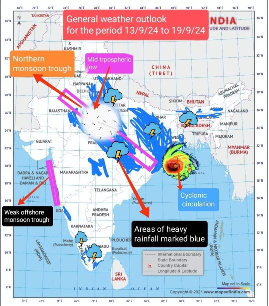
The cyclonic circulation over central Bay and a mid tropospheric circulation over north west India caused widespread rains over the north- west and central and south central Indian States. The monsoon trough has been slightly tilted south of its mean position at its north- west end and tiled south of its normal at its south-east end. The western offshore trough remained active from Gujarat to Malabar coast.
With so many back to back depressions and cyclonic circulation occurring, one might be wondering why all these circulations move only
north- west ward and not towards the east. This movement of depressions and cyclonic circulation is due to the physical law of conservation of relative vorticity of the air column and its latitudinal location.
As earth’s west to east spin imparts absolute planetary vorticity as is experienced in the Coriolis force, causing air parcels heading northward to turn right, the relative vorticity of the air parcel tries to balance the shear and curvature vorticities and conserve this and in this process the net effect is that the air column tends to drift poleward towards the west ( beta drifting). As the moment of inertia of the air parcel gets reduced as it moves to higher latitudes, it’s vorticity has to increase to conserve angular momentum.
So long as there is sufficient thermal energy and moisture supplied constantly through latent heat of condensation and evaporation or the latent heat flux which could run into a whopping several millions watts per sq metre. Despite the lower level westerlies, these vorticities happen at upper levels and and are not generally weakened or dissipated by the westerly steering winds.
At the same time due high vertical shear they do not become destructive cyclones either during the peak monsoon months. Nevertheless these depressions are copious rain givers. As the monsoon winds weaken by the end of September, these depressions start to become extremely & destructive. There are more complex factors involved in this process which can only be explained mathematically and numerically which is outside the scope of this blog. However the attached picture would give a general idea of the path that a cyclonic circulation takes.
Forecast: ( Effective from 06:00 hrs from. 13/09/24, to 23:59 hrs on 19/09/24.
The northern monsoon trough may continue to remain active and its north- west end may shift southward in the next 5-6 days. An upper air cyclonic circulation associated with the monsoon depression is likely over west Uttar Pradesh and adjoining parts of NCR Delhi, Uttrakhand from 12th to 14th September triggering exremely heavy rains in these areas.
Meanwhile a fresh monsoon depression is likely on 13 th September over the head of Bay.This system may progress westward accompanied by another spell of very heavy rains in Odisha, Bihar, Jharkhand, east & west Uttar Pradesh, Madhya Pradesh before it finally decays over easy Rajasthan by 19th or 20th September.
On 12th, 13th & 14 th September, fresh alert needed for NCR Delhi , Karnal, Paipat, Hissar and adjoining areas of Haryana, as there is a likelihood of extremely heavy rains . The entire Pauri- Garhwal, Karnaprayag, Joshimutt, Nainital, Mussoorie, and the lower western Himalayas would also be pounded by very heavy rains and micro cloudbursts on 13 th & 14 th September. Extreme caution may be exercised by tourists proceeding to the hills of Uttrakhand on these days.
North east Regions
Due to the fresh mid tropospheric cyclonic circulation associated with the monsoon depression, Meghalaya , upper Assam, sub-Himalayan west Bengal and extremely heavy rains may be expected in Silchar, upper Assam, Meghalaya, and Arunachal Pradesh on 13th and 14 th September. This system may progress westward and merge into the depression from the Bay on 11th September. As a consequence extremely heavy rains may be expected in Bihar, Jharkhand , West Bengal , sub-Himalayan west Bengal, on 14th and 15th.
The system may further move westwards unleashing extreme rains over east Uttar Pradesh , west Uttar Pradesh , east Madhya Pradesh, and west Madhya Pradesh on 16th and 17th September and peter out on 20 th September over western Madhya Pradesh and eastern Rajasthan.
Western, eastern,central and south India
The western offshore trough, may become weaker from 13 th September and as a result moderate rains may be restricted only from coastal Maharashtra to south coastal Karnataka.
The interior regions of Marathwada, and Madhya Maharashtra comprising places like Sholapur, Nashik, Pune, Aurangabad, Jalgaon may receive only light to moderate isolated rains from 13 th to 15 th September and the Vidarbha regions may remain dry.
The Telengana regions may get a respite after extremely heavy rains in the last week and weather is likely to be generally dry.
However due to trough in the easterlies and wind discontinuity Coastal and interior areas of Andhra Pradesh may expect isolated thunder showers on 14 th September.
In Chattisgarh and Odisha scattered heavy rains may be expected from 13th & 14 th due to the low pressure system associated with the monsoon depression over the Bay.
The western offshore trough may go weak with only light rains forecast for north coastal Karnataka and coastal Maharashtra. The Malabar regions of Kerala may remain generally dry and sunny woth occasional.light showers. But the eastern pockets of central and south Kerala, especially , eastern pockets of Ernakulam, Kottayam, and Idukki may expect isolated heavy thunder showers or rains on 14 th & 15 th September .
In Tamil Nadu, due to wind disntinuity and trough in the easterlies, isolated heavy thinderstorm activity may be expected in pockets like Ramanathapuram, Madhurai, Thirunelveli, Karaikudi, Peraiyur, Dindigul on 14 th and 15th September.
General distribution of rainfall and pockets of heavy rainfall alerts for the upcoming week:
North west India:( Moderate to heavy) Chandigarh, NCR Delhi , 12 th to 14 th September.
North- East India ( Heavy to very Heavy) Meghalaya, Imphal, Aizwal, As ilchar, Jorhat, Upper Assam, Guwahati on 14th & 15 th September 2024.
Uttrakhand & Himachal Pradesh:( Moderate to heavy) Uttarkashi, Mandi, Dharamshala, Pauri-Gharwal, Ranikhet, Chamoli, Mukteshwar, Halwani, Almora, Pithoragarh Mussoorie, Nainital, Karnaprayag on 12th 13 th and 14 th September.
Uttar Pradesh:( Heavy to very heavy) Bareilly, Faizabad, Agra, Jhansi , Moradabad, Meerut on 13 th September and in Prayagraj, Varanasi, Kanpur , Shahganj from 15 th to 17 th September.
Madhya Pradesh: ( Heavy to very heavy) Gwalior, Itarsi, Jabalpur, Nainpur, and Sagar from 16th to 18th September.
Gujarat: Nil.
Maharashtra & Goa: Nil
Andhra Pradesh & Telengana:
Nil
Karnataka:( Moderate to heavy)
Nil
Tamilnadu: No alert for very heavy rains.
KERALA
There is no specific alert for extreme heavy rainfall events anywhere in Kerala.
SPECIAL WEATHER ALERT FOR TRAVELLERS AND TOURISTS
North East India
Darjeeling, Gangtok, Siliguri, Arunachal Pradesh, Shillong Meghalaya likely to be rainy from 14/9/24 to 16/9/24. Heavy rains may be expected in Bongaigaon , Goalpara Guwahati, Jorhat and6b Herr f Silchar on these days .
Maximum and minimum temperature: 26°C & 20°C.
Uttrakhand:(Moderate to heavy)
Tourists bound for the hills in Uttrakhand may be on high alert on 13 th and 14th September as Uttarkashi, Pauri, Gharwal and Mussoorie, Nainital , and adjoining hill stations on the eastern Himalayas may expect extremely heavy rains on 13th & 14 th September.
Maximum day temperature 19°C and minimum 15°C in lower Himalayas and 11°C and 6°C in the greater Himalayas lying above 2500 metres above MSL.
The Kedarnath and Badrinath hill shrines in the Gharwal Himalayas may expect moderate to heavy snow or rain from 13th to 14 th September. Maximum day temperature in Kedarnath is likely to be 11°C and minimum 3-4°C. In Badrinath the maximum day temperature is likely to be 10°C and minimum at 3°C.
The Hemkund Sahib Gurudwara in the Gharwal Himalayas may expect heavy snow or rain from 13th to 14 th September. The maximum day temperature may be 7°C and minimum may range from 3°C to minus 2°C .
Himachal Pradesh .
Manali, Shimla, Bilaspur, Mandi , Kangra valley may expect heavy rains on 13 th and 14th September. Isolated extreme rainfall events, or flash floods and landslides may occur and holiday makers are advised to exercise some caution on these days while driving to the hills. Maximum & minimum temperature:
22°C and 15°C in lower Shivalik ranges and 15°C and 7°C in the upper Himalayas and Kinnaur ranges.
Jammu& Kashmir
Light rains on 13/9/24 . No heavy rain alerts. Maximum and minimum temperature 24°C and 15°C in Srinagar and 16°C and 6°C in the higher reaches of the Karakoram Pir Panjal and Ladakh ranges.
South India
Hillstations of Ooty and Kodaikanal may be pleasant with generally overcast skies. However Kodaikanal may expect isolated moderate to heavy thunder showers or rains on 14th September Maximum and minimum temperature: 20°C and 12°C in Ooty and 22°C and 12°C in Kodaikanal.
In Kerala the main hillstations of Kerala, , Wayanad , Munnar, Devikulam, Vagamon and Peerumade may expect moderate thunder showers rains on 14th September with maximum day temperature at 25°C and minimum in the range from to 20°C to 17°C depending on the altitude. In Kanthalloor , Vattavada the maximum temperature is likely to be in the range 19°C to 22°C and minimum temperature around 14°C to 16°C with chance of light rains on 14/9/24 . The backwaters in Alappuzha and Kumarakom may expect moderate spells of rains on 13th & 14th September.
(NB: Next weekly post on 20/09/24)
കാലാവസ്ഥ അപ്ഡേറ്റായിരിക്കാന് താഴെ കൊടുത്ത ഞങ്ങളുടെ ഗ്രൂപ്പുകളില് ചേരാം.
വാട്സ്ആപ്
ടെലഗ്രാം
വാട്സ്ആപ്പ് ചാനല്
Google News
Facebook Page
Weatherman Kerala Fb Page
https://biotpharm.shop/# buy antibiotics for uti
Medications online Australia: Buy medicine online Australia – PharmAu24
http://biotpharm.com/# buy antibiotics
Over the counter antibiotics pills: best online doctor for antibiotics – antibiotic without presription
online ed treatments: Ero Pharm Fast – Ero Pharm Fast
Online drugstore Australia pharmacy online australia Medications online Australia
Ero Pharm Fast Ero Pharm Fast cheap ed pills
Licensed online pharmacy AU: Discount pharmacy Australia – Licensed online pharmacy AU
http://biotpharm.com/# buy antibiotics
pharmacy online australia Pharm Au24 Pharm Au 24
cheapest antibiotics over the counter antibiotics antibiotic without presription
Medicaments en ligne livres en 24h: pharmacie en ligne pas cher – Pharmacie Internationale en ligne
viagra en ligne: Acheter du Viagra sans ordonnance – commander Viagra discretement
https://kampascher.com/# Kamagra oral jelly pas cher
Cialis generique sans ordonnance: traitement ED discret en ligne – acheter Cialis sans ordonnance
commander Kamagra en ligne: achat kamagra – commander Kamagra en ligne
traitement ED discret en ligne: commander Cialis en ligne sans prescription – commander Cialis en ligne sans prescription
kamagra livraison 24h kamagra 100mg prix acheter kamagra site fiable
prix bas Viagra generique: viagra en ligne – viagra sans ordonnance
kamagra pas cher: kamagra oral jelly – livraison discrete Kamagra
vente de m̩dicament en ligne: acheter Cialis sans ordonnance РCialis pas cher livraison rapide
https://viasansordonnance.com/# Viagra generique en pharmacie
acheter Viagra sans ordonnance commander Viagra discretement viagra sans ordonnance
pharmacies en ligne certifiГ©es: cialis prix – Cialis generique sans ordonnance
Viagra sans ordonnance 24h: Meilleur Viagra sans ordonnance 24h – viagra en ligne
kamagra pas cher: kamagra livraison 24h – acheter Kamagra sans ordonnance
kamagra pas cher: acheter kamagra site fiable – achat kamagra
livraison rapide Viagra en France commander Viagra discretement livraison rapide Viagra en France
pharmacie en ligne sans ordonnance: pharmacie en ligne РAchat m̩dicament en ligne fiable
https://pharmsansordonnance.shop/# pharmacies en ligne certifiГ©es
Viagra gГ©nГ©rique sans ordonnance en pharmacie: prix bas Viagra generique – prix bas Viagra generique
commander Viagra discretement: livraison rapide Viagra en France – livraison rapide Viagra en France
Viagra sans ordonnance 24h acheter Viagra sans ordonnance Viagra sans ordonnance 24h
livraison rapide Viagra en France: Acheter du Viagra sans ordonnance – Meilleur Viagra sans ordonnance 24h
kamagra 100mg prix: livraison discrete Kamagra – kamagra oral jelly
acheter Viagra sans ordonnance: Acheter du Viagra sans ordonnance – Meilleur Viagra sans ordonnance 24h
pharmacie en ligne pas cher commander sans consultation medicale vente de mГ©dicament en ligne
pharmacie en ligne sans ordonnance: commander sans consultation médicale – pharmacie en ligne france
https://ciasansordonnance.shop/# Acheter Cialis
pharmacie en ligne: pharmacie internet fiable France – pharmacie en ligne avec ordonnance
cialis sans ordonnance pharmacie en ligne pas cher commander Cialis en ligne sans prescription
pharmacie en ligne: achat kamagra – kamagra gel
Acheter Cialis: Cialis pas cher livraison rapide – acheter Cialis sans ordonnance
achat kamagra acheter Kamagra sans ordonnance kamagra gel
http://pharmsansordonnance.com/# pharmacie en ligne pas cher
Kamagra oral jelly pas cher: acheter kamagra site fiable – commander Kamagra en ligne
cialis generique: traitement ED discret en ligne – cialis generique
Acheter Cialis: Cialis pas cher livraison rapide – cialis generique
achat kamagra kamagra livraison 24h commander Kamagra en ligne
prix bas Viagra generique: Meilleur Viagra sans ordonnance 24h – viagra sans ordonnance
acheter médicaments sans ordonnance: pharmacie en ligne sans ordonnance – pharmacie en ligne france
http://pharmsansordonnance.com/# pharmacie en ligne
Viagra generique en pharmacie Acheter du Viagra sans ordonnance viagra en ligne
pharmacie en ligne: pharmacie en ligne – pharmacie en ligne france fiable
commander sans consultation medicale pharmacie internet fiable France pharmacie en ligne sans ordonnance
prix bas Viagra generique: Acheter du Viagra sans ordonnance – Acheter du Viagra sans ordonnance
pharmacie en ligne pas cher: acheter medicaments sans ordonnance – п»їpharmacie en ligne france
commander Kamagra en ligne: Kamagra oral jelly pas cher – kamagra livraison 24h
https://pharmsansordonnance.com/# pharmacies en ligne certifiГ©es
kamagra livraison 24h pharmacie en ligne avec ordonnance commander Kamagra en ligne
pharmacie internet fiable France: pharmacie en ligne pas cher – pharmacie en ligne france fiable
Viagra sans ordonnance 24h: acheter Viagra sans ordonnance – Viagra sans ordonnance 24h
Pharmacie sans ordonnance: achat kamagra – kamagra gel
livraison rapide Viagra en France prix bas Viagra generique prix bas Viagra generique
https://kampascher.shop/# acheter Kamagra sans ordonnance
Cialis generique sans ordonnance: acheter Cialis sans ordonnance – acheter Cialis sans ordonnance
pharmacie en ligne sans prescription: pharmacie en ligne sans prescription – Pharmacie sans ordonnance
commander sans consultation medicale: pharmacie en ligne sans prescription – pharmacie en ligne
Kamagra oral jelly pas cher Kamagra oral jelly pas cher Kamagra oral jelly pas cher
achat kamagra: commander Kamagra en ligne – acheter Kamagra sans ordonnance
https://kampascher.shop/# kamagra oral jelly
acheter kamagra site fiable kamagra oral jelly kamagra en ligne
pharmacie en ligne sans prescription: pharmacie en ligne – vente de mГ©dicament en ligne
livraison rapide Viagra en France acheter Viagra sans ordonnance viagra sans ordonnance
commander sans consultation medicale: pharmacie en ligne sans ordonnance – acheter mГ©dicament en ligne sans ordonnance
Acheter Cialis Cialis pas cher livraison rapide Cialis pas cher livraison rapide
acheter medicaments sans ordonnance: pharmacie internet fiable France – pharmacie en ligne france fiable
https://pharmsansordonnance.shop/# pharmacies en ligne certifiГ©es
Meilleur Viagra sans ordonnance 24h: livraison rapide Viagra en France – Viagra gГ©nГ©rique sans ordonnance en pharmacie
acheter Cialis sans ordonnance acheter Cialis sans ordonnance acheter Cialis sans ordonnance
Acheter du Viagra sans ordonnance: Meilleur Viagra sans ordonnance 24h – acheter Viagra sans ordonnance
Cialis sans ordonnance 24h acheter Cialis sans ordonnance cialis generique
pharmacie internet fiable France: pharmacie en ligne sans prescription – pharmacie en ligne fiable
https://kampascher.shop/# livraison discrete Kamagra
Medicaments en ligne livres en 24h pharmacie internet fiable France trouver un mГ©dicament en pharmacie
Acheter Cialis 20 mg pas cher: traitement ED discret en ligne – Acheter Cialis
prix bas Viagra generique Acheter du Viagra sans ordonnance SildГ©nafil 100 mg prix en pharmacie en France
farmacia online en cantabria: eroxon se puede comprar sin receta – parafarmacia y farmacia en casa online
donde comprar betametasona sin receta: farmacia online salvador – isdin farmacia online
http://farmaciasubito.com/# rosumibe 10/10
ordonnance simple Pharmacie Express periactine en pharmacie sans ordonnance
lansox 15 mg compresse orodispersibili prezzo: coaprovel 300 mg/12 5 mg prezzo – pentacol 500 supposte prezzo
amoxicilline pour chat sans ordonnance: viagra generique en pharmacie sans ordonnance – traitement hГ©morroГЇdes sans ordonnance
pharmacie en ligne sans ordonnance levitra ozempic sans ordonnance daflon sans ordonnance en pharmacie
farmacia lanzarote online: farmacia shop online milano – tamoxifeno farmacia online
http://farmaciasubito.com/# farmacia online pubblicitГ in tv
farmacia online punto di ritiro [url=http://farmaciasubito.com/#]riopan acquisto online[/url] galastop prezzo 50 ml
commander tadalafil sans ordonnance: qu’est ce qui remplace le viagra en pharmacie sans ordonnance – commander viagra en ligne
clensia e mutuabile: tredimin gocce – lampard 25.000 flaconcini
mГ©dicament contre le stress sans ordonnance: acheter medicament sans ordonnance – antibiotique pour infection urinaire sans ordonnance
mascherine farmacia online farmacia online getafe comprar cialis sin receta medica farmacia
https://confiapharma.shop/# farmacia online corral
cupГіn descuento farmacia online: Confia Pharma – ovoplex farmacia online
amoxicilline enfant sans ordonnance: spedra 200 mg – pharmacie en ligne sans ordonnance cialis
se puede comprar losartan sin receta vantaggi farmacia online farmacia online prednisona
farmacia online recogida en tienda: Confia Pharma – farmacia shopping online
deltacortene prezzo senza ricetta: Farmacia Subito – remifemin per quanto tempo si prende
pendientes farmacia online: Confia Pharma – farmacia galenica online
dicloreum 150 senza ricetta prezzo: farmacia online migliori – torvast 40 prezzo
theo-dur 200 prezzo arimidex prezzo nimotop gocce prezzo
farmacia online tadalafil: debridat prezzo – muscoril prezzo senza ricetta
toco 500 sans ordonnance: pilule sans ordonnance pharmacie – daflon autre nom
antibiotiques infection urinaire sans ordonnance laboratoire sans ordonnance betamethasone sans ordonnance prix
http://confiapharma.com/# comprar alprazolam sin receta espaГ±a
donde puedo comprar cytotec sin receta: puedo comprar metformina sin receta – metformin comprar sin receta
productos ortopedia farmacia online: Confia Pharma – comprar yodocefol sin receta
farmacia online vichy Confia Pharma farmacia online para rumanos
ecbu sans ordonnance pharmacie: peut-on acheter du viagra en pharmacie sans ordonnance – antibiotique otite sans ordonnance
cialis sans ordonnance pharmacie en ligne: antihistaminique vendu en pharmacie sans ordonnance – smecta enfant 3 ans
testostГ©rone en pharmacie sans ordonnance au maroc zona traitement pharmacie sans ordonnance viagra achat
amoxicilline ordonnance: cialis sans ordonnance en pharmacie – ou commander du viagra
unica farmacia online: farmacia online valdemoro – doc peter farmacia online
prezzo oki bustine test rapido covid farmacia online cilodex gocce e mutuabile prezzo
alcion farmaco farmacia dott max bologna combistill collirio
top farmacia ordini online: Farmacia Subito – meloxidyl gatto
crГЁme rap pour varices: ictyane creme emolliente – qu’est ce qui remplace le viagra en pharmacie sans ordonnance
cialis 20 mg: comment avoir des antibiotiques sans ordonnance – amoxicillin sans ordonnance
https://pharmacieexpress.com/# shampoing ds ducray
comprar cialis sin receta medica farmacia farmacia online colageno farmacia cursos online
etoricoxib 90 mg prezzo: tranex fiale per via orale – timogel collirio monodose
mouche bebe poire: cbd en pharmacie sans ordonnance belgique – ordonnance medecin
se puede comprar declobГЎn sin receta curso auxiliar de farmacia y parafarmacia online se puede comprar lorazepam sin receta mГ©dica
se puede comprar valaciclovir sin receta: comprar myolastan sin receta – el clonazepam se puede comprar sin receta
farmacia creu verda online: farmacia online andorra barata – se puede comprar famciclovir sin receta
https://pharmacieexpress.com/# acheter tadalafil 10mg en ligne
fripass 100 mg prezzo gabapentin 100 mg prezzo farmacia san michele montemerlo
farmacia online prezzi bassi: serena ovuli effetti collaterali – visunac collirio prezzo
medicament avec ordonnance: selexid 200 mg sans ordonnance – spedra sans ordonnance en pharmacie
bivis 20/5 farmacia economica online oki bustine 80 mg online
nobistar a cosa serve: lansoprazolo 30 mg – pillola estinette prezzo
mederma controindicazioni rifacol principio attivo vessel 250 uls amazon
http://farmaciasubito.com/# sildenafil 100 mg prezzo in farmacia
thyrax sans ordonnance: infection urinaire ordonnance – acheter viagra en ligne
minias gocce compra online nerisona crema triasporin soluzione orale prezzo
somnifere en pharmacie sans ordonnance: coquelusedal avec ou sans ordonnance – antibiotiques cystite sans ordonnance
medplus pharmacy india: InPharm24 – india pharmacy online
https://inpharm24.com/# online medicine in india
legal online pharmacy: omeprazole online pharmacy – us pharmacy no prior prescription
pharmacy names in india doctor of pharmacy in india top online pharmacy in india
online pharmacy flovent inhaler: Pharm Express 24 – precision pharmacy omeprazole
best online pharmacy in india: InPharm24 – india online pharmacy
online pharmacy percocet 30 mg Pharm Express 24 mexican online pharmacy percocet
valtrex pharmacy coupon: pharmacy rx one coupon code – levitra pharmacy coupon
why is pharmacy rx: Pharm Express 24 – rohypnol mexico pharmacy
what can i buy in a mexican pharmacy: medicine from mexico – prednisone mexican pharmacy
most trusted canadian online pharmacy: prescriptions online pharmacy – mexican medicine near me
buy medicines online india pharmacy course india medications from india
pharmacy council of india: InPharm24 – pharmacy course india
can you bring medicine from mexico into the us: acyclovir mexico pharmacy – over the counter drugs mexico
online pharmacy busted: Pharm Express 24 – Vermox
costa rica pharmacy online web rx pharmacy palace wellbutrin sr pharmacy
pharmacy education in india: online pharmacy in india – indian pharmacies
best online pharmacy india: medicine from india – drugs from india
pharmacy india: india pharmacy no prescription – doctor of pharmacy india
fluconazole online pharmacy Pharm Express 24 sam’s club pharmacy viagra price
fluconazole pharmacy: Sumycin – online pharmacy no prescription concerta
pharmacy council of india: InPharm24 – india mart pharmacy
azelaic acid india pharmacy: online medicine delivery in india – b pharmacy salary in india
propecia pharmacy uk pharmacy book store proscar pharmacy
https://inpharm24.shop/# ivermectin india pharmacy
mexican pharmacy good health: legitimate online mexican pharmacy – mexican medicine
mounjaro availability in mexico: Pharm Mex – legit online mexican pharmacy
house pharmacy finpecia: panadol pharmacy – tegretol online pharmacy
how much is adderall in mexico houston spine and joint top mail order pharmacies in usa
pharmacy online shopping usa: Pharm Express 24 – your rx pharmacy grapevine tx
pharmacy names in india: order medicines online – dandruff shampoo india pharmacy
india pharmacy delivery to usa india pharmacy market india drug store
https://pharmmex.shop/# best canadian pharmacy for us citizens
online medication store: pharmacy in mexico city – meds mexico
cheap online pharmacy india: InPharm24 – online pharmacy india
pharmacy one rx lamotrigine target pharmacy tesco pharmacy products viagra
prednisone over the counter in mexico: lone star spine and pain – buy meds online
india pharmacy delivery india online pharmacy apollo pharmacy india
pharmacy name ideas in india: best pharmacy franchise in india – online medicine order
cialis professional: cialis pharmacy coupon – celexa online pharmacy
http://inpharm24.com/# online pharmacy india
international pharmacy best rx pharmacy trustworthy online pharmacy
semaglutide mexico pharmacy: Pharm Mex – 5-fu mexican pharmacy
mail order mounjaro mounjaro for sale in mexico xanax from mexican pharmacy
sildenafil where to get VGR Sources viagra discounts
buy viagra over the counter: VGR Sources – generic sildenafil canada
sildenafil 100mg generic buy viagra super active cheap generic viagra no prescription
https://vgrsources.com/# viagra pills australia
best viagra in india: cheap viagra for sale online – us online viagra
buy cheap generic viagra online: VGR Sources – how to buy generic viagra in canada
buy viagra online mastercard where to get viagra online viagra 50 mg price
https://vgrsources.com/# viagra 100mg price canada
generic viagra soft pills: prezzo viagra 50mg – viagra generic in mexico
buy real viagra online no prescription generic viagra cheapest price sildenafil 20mg online prescription
real viagra online no prescription: order viagra mexico – sildenafil purchase india
viagra online in india where to buy sildenafil online where to get female viagra uk
https://vgrsources.com/# sildenafil purchase india
how much is a viagra prescription: VGR Sources – viagra usa
female viagra pill viagra 100mg india price viagra otc us
can i buy viagra online without a prescription: VGR Sources – generic viagra buy online
sildenafil chewable tablets VGR Sources Viagra 50 mg Preço
sildenafil 20mg prescription cost: VGR Sources – female viagra for sale
https://vgrsources.com/# generic viagra 50mg
female viagra pill prescription cheap viagra pills for sale average cost of viagra 100mg
viagra generic online canada: viagra 200mg online – order viagra united states
buy viagra safely online uk VGR Sources generic female viagra in india
generic viagra soft tab: VGR Sources – sildenafil tablets from india 100mg tablets
https://vgrsources.com/# where to buy viagra online without prescription
where to purchase female viagra buy female viagra pills in india online sildenafil 50mg india
generic viagra buy online india: VGR Sources – cheap viagra
generic viagra otc generic viagra from india online buy viagra uk paypal
how to order viagra in canada: VGR Sources – viagra canada fast shipping
https://vgrsources.com/# generic 100mg sildenafil
cheap generic viagra 25mg VGR Sources sildenafil 1000 mg
viagra 100mg tabs: VGR Sources – paypal viagra australia
viagra price comparison usa viagra 100 mg price canada viagra soft 100mg online canadian pharmacy
viagra online from utah: viagra price in usa – best sildenafil coupon
https://vgrsources.com/# viagra on line
viagra 100 mg tablet price VGR Sources sildenafil cost uk
canadian pharmacy viagra 100 mg: VGR Sources – buy viagra for female online india
Lipi Pharm Order cholesterol medication online Lipi Pharm
rosuvastatin uses: CrestorPharm – Order rosuvastatin online legally
http://prednipharm.com/# prednisone 5mg over the counter
Atorvastatin online pharmacy: Order cholesterol medication online – LipiPharm
is semaglutide safe for weight loss: rybelsus price in usa – compounded semaglutide weight loss dosage chart
Semaglu Pharm semaglutide vs compounded semaglutide SemagluPharm
https://crestorpharm.shop/# CrestorPharm
crestor adverse effects: Online statin therapy without RX – п»їBuy Crestor without prescription
PredniPharm buy prednisone 50 mg Predni Pharm
Affordable Rybelsus price: SemagluPharm – SemagluPharm
PredniPharm: PredniPharm – Predni Pharm
LipiPharm Lipi Pharm lipitor help lose weight
https://lipipharm.com/# Lipi Pharm
lipitor lawsuit muscle damage: lipitor statin – LipiPharm
FDA-approved Rybelsus alternative semaglutide thyroid cancer rybelsus benefits
Predni Pharm: Predni Pharm – PredniPharm
Semaglu Pharm SemagluPharm Order Rybelsus discreetly
https://semaglupharm.com/# semaglutide not losing weight
semaglutide success stories: Semaglu Pharm – SemagluPharm
Crestor Pharm Safe online pharmacy for Crestor rosuvastatin cause diabetes
50 mg prednisone canada pharmacy: price for 15 prednisone – Predni Pharm
SemagluPharm Rybelsus side effects and dosage Semaglu Pharm
https://semaglupharm.shop/# fda compounded semaglutide
buy prednisone 20mg: Predni Pharm – 2.5 mg prednisone daily
Lipi Pharm Lipi Pharm LipiPharm
Crestor Pharm: rosuvastatin and thc – CrestorPharm
CrestorPharm CrestorPharm CrestorPharm
https://lipipharm.shop/# Lipi Pharm
Online pharmacy Rybelsus: can you stop rybelsus cold turkey – SemagluPharm
Safe atorvastatin purchase without RX crestor to lipitor conversion Lipi Pharm
Semaglutide tablets without prescription: taking rybelsus for weight loss – Semaglu Pharm
LipiPharm Lipi Pharm LipiPharm
SemagluPharm rybelsus 14 mg reviews SemagluPharm
http://crestorpharm.com/# Crestor Pharm
SemagluPharm: SemagluPharm – No prescription diabetes meds online
https://semaglupharm.shop/# Semaglu Pharm
https://semaglupharm.shop/# semaglutide rybelsus 7mg
PredniPharm: can i order prednisone – Predni Pharm
http://semaglupharm.com/# FDA-approved Rybelsus alternative
CrestorPharm CrestorPharm CrestorPharm
http://crestorpharm.com/# can crestor cause hair loss
https://semaglupharm.shop/# SemagluPharm
Semaglu Pharm Semaglu Pharm phentermine vs semaglutide
Rybelsus for blood sugar control: Semaglu Pharm – Order Rybelsus discreetly
https://semaglupharm.shop/# SemagluPharm
PredniPharm: PredniPharm – can you buy prednisone over the counter in canada
Semaglu Pharm Semaglu Pharm SemagluPharm
http://semaglupharm.com/# Semaglu Pharm
https://semaglupharm.com/# Buy Rybelsus online USA
SemagluPharm: Order Rybelsus discreetly – SemagluPharm
CrestorPharm another name for crestor CrestorPharm
https://semaglupharm.com/# rybelsus and mounjaro together
Online pharmacy Rybelsus: SemagluPharm – Affordable Rybelsus price
Semaglu Pharm SemagluPharm Rybelsus for blood sugar control
https://semaglupharm.com/# Semaglu Pharm
https://semaglupharm.com/# Online pharmacy Rybelsus
Affordable cholesterol-lowering pills: Crestor Pharm – crestor vs pravachol
Crestor Pharm Crestor Pharm Crestor home delivery USA
https://semaglupharm.com/# Semaglu Pharm
Predni Pharm: prednisone 5443 – PredniPharm
https://semaglupharm.com/# rybelsus walmart
http://crestorpharm.com/# CrestorPharm
Predni Pharm: prednisone cream rx – PredniPharm
Lipi Pharm Lipi Pharm Lipi Pharm
https://semaglupharm.com/# FDA-approved Rybelsus alternative
prednisone 10mg prices: PredniPharm – Predni Pharm
SemagluPharm semaglutide dosage in ml Where to buy Semaglutide legally
https://semaglupharm.shop/# farxiga and rybelsus
http://crestorpharm.com/# CrestorPharm
Crestor Pharm: does rosuvastatin lower triglycerides – CrestorPharm
http://semaglupharm.com/# Order Rybelsus discreetly
prednisone 2 mg daily prednisone acetate Predni Pharm
https://medsfrommexico.shop/# Meds From Mexico
legitimate canadian pharmacy online canadian online pharmacy reviews canadian pharmacy online
http://canadapharmglobal.com/# buy drugs from canada
http://canadapharmglobal.com/# canadian pharmacy cheap
Meds From Mexico: reputable mexican pharmacies online – Meds From Mexico
India Pharm Global India Pharm Global top online pharmacy india
https://medsfrommexico.shop/# mexico drug stores pharmacies
buy medicines online in india: best india pharmacy – India Pharm Global
Meds From Mexico mexican rx online Meds From Mexico
https://canadapharmglobal.com/# canadian pharmacy near me
https://canadapharmglobal.shop/# canadian pharmacy king reviews
buying prescription drugs in mexico: Meds From Mexico – medication from mexico pharmacy
india pharmacy mail order India Pharm Global online pharmacy india
¡Saludos, participantes de emociones !
Casinos extranjeros con bonos por fidelidad constantes – https://casinosextranjerosenespana.es/# casino online extranjero
¡Que vivas increíbles victorias épicas !
https://medsfrommexico.com/# Meds From Mexico
mexico pharmacies prescription drugs: mexican pharmaceuticals online – reputable mexican pharmacies online
Meds From Mexico mexico drug stores pharmacies Meds From Mexico
http://canadapharmglobal.com/# canadian drugs pharmacy
pharmacy wholesalers canada: Canada Pharm Global – canadian pharmacy world reviews
canadian pharmacy oxycodone Canada Pharm Global canadian drugs online
http://canadapharmglobal.com/# canadian drugs
canadian drugstore online: best canadian online pharmacy – 77 canadian pharmacy
¡Hola, exploradores de recompensas !
Casinossinlicenciaespana.es – Registro rГЎpido – https://casinossinlicenciaespana.es/# casino sin licencia espaГ±a
¡Que experimentes conquistas extraordinarias !
http://indiapharmglobal.com/# indian pharmacy online
canada ed drugs precription drugs from canada canada online pharmacy
https://canadapharmglobal.com/# canadian pharmacy 24 com
¡Hola, descubridores de recompensas !
Top 10 casinos online fuera de EspaГ±a para este aГ±o – https://www.casinoonlinefueradeespanol.xyz/# casinoonlinefueradeespanol.xyz
¡Que disfrutes de asombrosas movidas brillantes !
cheapest online pharmacy india: indian pharmacy online – indian pharmacies safe
https://medsfrommexico.com/# Meds From Mexico
canadianpharmacymeds com best canadian pharmacy to order from canadian pharmacy oxycodone
https://canadapharmglobal.shop/# online pharmacy canada
Meds From Mexico Meds From Mexico Meds From Mexico
https://canadapharmglobal.com/# canada drugs
Svenska Pharma: Svenska Pharma – Svenska Pharma
https://svenskapharma.com/# köp medicin online
Svenska Pharma blodtrycksmedicin gravid hydroquinone apotek
Svenska Pharma: apotek halsont – billig dricka
http://papafarma.com/# cepillo oral-b no funciona
¡Saludos, fanáticos del entretenimiento !
casinos extranjeros con pago inmediato a PayPal – п»їhttps://casinosextranjero.es/ п»їcasinos online extranjeros
¡Que vivas increíbles jugadas excepcionales !
farmacia tienda Papa Farma crema viagra
https://svenskapharma.shop/# gurkmeja apotek
Rask Apotek: vinsyre apotek – hydrogenperoksid apotek
http://papafarma.com/# venta de farmacia
Rask Apotek Rask Apotek Rask Apotek
Rask Apotek: vaksine pГҐ apotek – kanyle apotek
http://papafarma.com/# Papa Farma
Svenska Pharma: Svenska Pharma – Svenska Pharma
https://svenskapharma.shop/# Svenska Pharma
EFarmaciaIt EFarmaciaIt delecit cosa serve
gentalyn beta in gravidanza forum: EFarmaciaIt – EFarmaciaIt
https://papafarma.com/# Papa Farma
http://svenskapharma.com/# gratis medicin
http://raskapotek.com/# ph papir apotek
travocort crema online banco significato EFarmaciaIt
http://papafarma.com/# gelasimi forte
Papa Farma: dodot activity talla 6 plus – farmacia ahorro valladolid
¡Hola, entusiastas de la emoción !
casinoextranjero.es – todo lo que necesitas para apostar – https://www.casinoextranjero.es/# mejores casinos online extranjeros
¡Que vivas botes deslumbrantes!
http://raskapotek.com/# elektrolytter drikke apotek
Svenska Pharma p piller apotek Svenska Pharma
http://efarmaciait.com/# efacti crema online
http://efarmaciait.com/# EFarmaciaIt
apotek hГ¤mta recept: Svenska Pharma – billiga mellanmГҐl
parafarmacia natural la boutique del sabor murcia Papa Farma
http://papafarma.com/# precio de movicol
Papa Farma precio diu mirena espaГ±a Papa Farma
https://papafarma.com/# parafarmacias sevilla
https://papafarma.com/# Papa Farma
mg murcia: Papa Farma – Papa Farma
¡Bienvenidos, amantes del entretenimiento !
Casino por fuera con jackpots progresivos – https://www.casinoporfuera.guru/# casinos online fuera de espaГ±a
¡Que disfrutes de maravillosas momentos memorables !
gentalyn beta spray EFarmaciaIt bruciore ombelico
https://papafarma.com/# parque alcosa como llegar
¡Saludos, amantes de la emoción !
casino online fuera de EspaГ±a accesible y rГЎpido – https://www.casinosonlinefueraespanol.xyz/# п»їcasino fuera de espaГ±a
¡Que disfrutes de movidas extraordinarias !
bestill reseptvarer pГҐ nett Rask Apotek Rask Apotek
http://efarmaciait.com/# EFarmaciaIt
http://svenskapharma.com/# Svenska Pharma
EFarmaciaIt: EFarmaciaIt – bisoprololo 1,25
Papa Farma opiniones de mg Papa Farma
pharmacie garde lyon 8: pharamcie – pilulier en bois
https://pharmaconfiance.com/# minuteur pour douche
Medicijn Punt online apotheek 24 Medicijn Punt
https://pharmaconfiance.shop/# guigoz algerie
bestellen apotheek: farma – apotheek apotheek
https://medicijnpunt.com/# Medicijn Punt
cetirizine autre nom ggp auto montpellier Pharma Confiance
¡Hola, estrategas del entretenimiento !
Casino online extranjero con RTP garantizado – https://www.casinosextranjerosdeespana.es/ casinos extranjeros
¡Que vivas increíbles jackpots sorprendentes!
https://medicijnpunt.shop/# MedicijnPunt
apotheek kopen: MedicijnPunt – Medicijn Punt
fucidine crГЁme posologie pharmacien officine Pharma Confiance
https://pharmaconnectusa.com/# viagra professional online pharmacy
https://pharmajetzt.com/# sofort apotheke
ez online pharmacy buy viagra usa PharmaConnectUSA PharmaConnectUSA
https://medicijnpunt.com/# MedicijnPunt
https://pharmajetzt.shop/# PharmaJetzt
PharmaJetzt апотека PharmaJetzt
https://medicijnpunt.shop/# MedicijnPunt
Medicijn Punt Medicijn Punt aptoheek
https://pharmaconfiance.com/# pommade pénicilline sans ordonnance
pharmacie franГ§aise en ligne: laboratoire de garde strasbourg – prix lysopaine pharmacie
PharmaJetzt tabletten kaufen PharmaJetzt
http://pharmaconnectusa.com/# uk pharmacy viagra prices
pharmacie ouverte autour de moi aujourd’hui: eu pharmacie avis – Pharma Confiance
https://pharmajetzt.shop/# medikament bestellen
MedicijnPunt online apotheken MedicijnPunt
apotheke internet: gГјnstige apotheke online shop – apothekenversand
http://pharmajetzt.com/# Pharma Jetzt
Pharma Confiance Pharma Confiance pharmacie shop
https://pharmaconnectusa.shop/# tricare pharmacy
shampoing sante: Pharma Confiance – pharmacie de garde belle ile
¡Bienvenidos, estrategas del entretenimiento !
Casino fuera de EspaГ±a con plataforma optimizada – https://www.casinofueraespanol.xyz/# п»їп»їcasino fuera de espaГ±a
¡Que vivas increíbles giros exitosos !
https://pharmaconnectusa.shop/# trust pharmacy online reviews
veterans online pharmacy voltaren gel online pharmacy online pharmacy florida
Pharma Confiance: Pharma Confiance – Pharma Confiance
https://pharmaconnectusa.shop/# med rx pharmacy
arznei gГјnstig versand apotheke online versandapotheke bad steben
effet amoxicilline: Pharma Confiance – pharmacie de garde 80
https://pharmajetzt.com/# Pharma Jetzt
¡Saludos, maestros del juego !
Casino online extranjero con live streaming – https://casinoextranjerosdeespana.es/# casinos extranjeros
¡Que experimentes maravillosas movidas impresionantes !
http://pharmaconfiance.com/# Pharma Confiance
PharmaConnectUSA viagra pfizer online pharmacy PharmaConnectUSA
first rx pharmacy statesville nc: dapoxetine uk pharmacy – PharmaConnectUSA
https://pharmaconnectusa.shop/# us online pharmacy reviews
PharmaConnectUSA: levitra target pharmacy – Pharma Connect USA
boite rose pharmacie ivermectine comprimГ© cbd gummies pharmacie
https://pharmajetzt.shop/# Pharma Jetzt
https://pharmaconnectusa.com/# PharmaConnectUSA
?Hola, estrategas del riesgo !
casinos fuera de EspaГ±a para grandes ganancias – https://www.casinosonlinefueradeespanol.xyz/ casinos online fuera de espaГ±a
?Que disfrutes de asombrosas triunfos epicos !
MedicijnPunt Medicijn Punt apotheke
http://pharmajetzt.com/# PharmaJetzt
http://pharmajetzt.com/# PharmaJetzt
https://pharmaconfiance.shop/# Pharma Confiance
medicijnen bestellen apotheek: holandia apteka internetowa – MedicijnPunt
online pharmacy viagra generic PharmaConnectUSA Pharma Connect USA
http://pharmajetzt.com/# PharmaJetzt
online pharmacy fioricet: PharmaConnectUSA – PharmaConnectUSA
https://medicijnpunt.com/# medicatielijst apotheek
Medicijn Punt MedicijnPunt Medicijn Punt
http://pharmaconnectusa.com/# global online pharmacy
https://medicijnpunt.shop/# recept medicijnen
flagyl creme: Pharma Confiance – veto lourdes
¡Hola, participantes del desafío !
Casino sin licencia en EspaГ±a sin tiempos de espera – п»їhttps://casinosinlicenciaespana.xyz/ casinosinlicenciaespana
¡Que vivas increíbles jugadas brillantes !
https://pharmajetzt.shop/# ahop apotheke
people’s pharmacy wellbutrin PharmaConnectUSA Pharma Connect USA
https://pharmaconnectusa.shop/# online pharmacy uk no prescription viagra
http://pharmajetzt.com/# apo apotheke online
PharmaConnectUSA PharmaConnectUSA PharmaConnectUSA
https://medicijnpunt.com/# Medicijn Punt
ED Trial Pack PharmaConnectUSA Pharma Connect USA
http://pharmaconnectusa.com/# Pharma Connect USA
Pharma Confiance livraison mГ©dicaments avec ordonnance Pharma Confiance
https://pharmaconfiance.shop/# pharmacie du grand paris
shopapothe luitpold apotheke wГјrzburg Pharma Jetzt
Pharma Connect USA: Pharma Connect USA – metronidazole uk pharmacy
https://medicijnpunt.com/# farma
https://pharmaconfiance.com/# Pharma Confiance
Pharma Confiance: Pharma Confiance – Pharma Confiance
PharmaJetzt Pharma Jetzt online apotheke auf rechnung
http://medicijnpunt.com/# antibiotica kopen zonder recept
https://medicijnpunt.com/# Medicijn Punt
apotheek inloggen: MedicijnPunt – MedicijnPunt
MedicijnPunt online apotheek zonder recept ervaringen MedicijnPunt
http://pharmaconnectusa.com/# overseas pharmacy cialis
https://pharmaconfiance.com/# Pharma Confiance
Pharma Connect USA PharmaConnectUSA pain meds online pharmacy
MedicijnPunt: MedicijnPunt – medicijn
stat rx pharmacy: PharmaConnectUSA – PharmaConnectUSA
online apotheken medicij MedicijnPunt
holland apotheke: MedicijnPunt – MedicijnPunt
http://medicijnpunt.com/# Medicijn Punt
https://pharmajetzt.shop/# apotheke selbitz
pharmacie rue du commerce: 39 de fiГЁvre sous antibiotique – Pharma Confiance
Pharma Confiance Pharma Confiance Pharma Confiance
https://pharmaconnectusa.com/# pharmacy warfarin counselling
apotheke online ohne versandkosten: PharmaJetzt – versandapotheke gГјnstig
billige medikamente: versandapotheke – Pharma Jetzt
¡Saludos, apostadores talentosos !
Casino sin licencia en Espana actualizado – https://audio-factory.es/ casino online sin licencia
¡Que disfrutes de asombrosas momentos irrepetibles !
online apotheke versandkostenfrei auf rechnung Pharma Jetzt online apptheke
MedicijnPunt: medicijnlijst apotheek – pseudoephedrine kopen in nederland
https://pharmaconnectusa.com/# Pharma Connect USA
https://pharmaconnectusa.shop/# Pharma Connect USA
¡Hola, participantes de desafíos emocionantes !
Casino online sin licencia y juegos en tiempo real – п»їcasinosonlinesinlicencia.es https://www.casinosonlinesinlicencia.es/
¡Que vivas increíbles jugadas destacadas !
medis medikamente: apotheke germany – onlin apotheke
https://pharmaconfiance.com/# daflon duree du traitement
PharmaConnectUSA: what’s the best online pharmacy – Pharma Connect USA
effet amoxicilline: Pharma Confiance – viagra sans ordonnance 24h avis
https://pharmaconnectusa.com/# PharmaConnectUSA
luitpoldapotheke Pharma Jetzt luitpold apotheke online
PharmaConnectUSA: Pharma Connect USA – PharmaConnectUSA
¡Saludos, maestros del azar !
Emausong.es: casino online sin verificaciГіn KYC – https://www.emausong.es/ casino online sin licencia espaГ±a
¡Que disfrutes de increíbles recompensas únicas !
http://canrxdirect.com/# buy drugs from canada
canada drug pharmacy CanRx Direct 77 canadian pharmacy
IndiMeds Direct: IndiMeds Direct – indian pharmacies safe
https://canrxdirect.shop/# online canadian pharmacy
https://canrxdirect.shop/# canadian pharmacy world reviews
indian pharmacy online Online medicine home delivery mail order pharmacy india
IndiMeds Direct: Online medicine order – world pharmacy india
https://canrxdirect.com/# vipps canadian pharmacy
mexican rx online TijuanaMeds TijuanaMeds
TijuanaMeds: mexican online pharmacies prescription drugs – purple pharmacy mexico price list
http://canrxdirect.com/# canadian pharmacy 1 internet online drugstore
https://tijuanameds.com/# TijuanaMeds
IndiMeds Direct IndiMeds Direct п»їlegitimate online pharmacies india
buying prescription drugs in mexico online: TijuanaMeds – mexican mail order pharmacies
http://tijuanameds.com/# pharmacies in mexico that ship to usa
canadian pharmacy 365 medication canadian pharmacy pharmacy in canada
canada drugstore pharmacy rx: CanRx Direct – canada rx pharmacy world
https://canrxdirect.shop/# canada drugs
https://indimedsdirect.shop/# IndiMeds Direct
canadian pharmacy online reviews ed meds online canada canada pharmacy
http://tijuanameds.com/# TijuanaMeds
¡Saludos, descubridores de riquezas secretas !
Casinosonlineconbonodebienvenida de calidad – http://bono.sindepositoespana.guru/# casino bono de bienvenida
¡Que disfrutes de asombrosas tiradas exitosas !
https://tijuanameds.com/# TijuanaMeds
TijuanaMeds TijuanaMeds mexican rx online
reputable mexican pharmacies online: TijuanaMeds – TijuanaMeds
https://tijuanameds.shop/# п»їbest mexican online pharmacies
https://tijuanameds.shop/# TijuanaMeds
safe online pharmacies in canada canadian pharmacy 365 pharmacy in canada
farmacia 24 h valencia: precio viagra espaГ±a – dodot activity talla 4
http://farmaciaasequible.com/# Farmacia Asequible
enclomiphene price enclomiphene for men enclomiphene for men
casenlax 10 mg: Farmacia Asequible – Farmacia Asequible
https://farmaciaasequible.com/# farmacias top opiniones
http://enclomiphenebestprice.com/# enclomiphene price
Farmacia Asequible Farmacia Asequible Farmacia Asequible
Greetings, lovers of jokes and good humor !
Short jokes for adults one-liners gold – п»їhttps://jokesforadults.guru/ adult humor jokes
May you enjoy incredible successful roasts !
enclomiphene: enclomiphene price – enclomiphene
https://enclomiphenebestprice.com/# enclomiphene citrate
Farmacia Asequible Farmacia Asequible Farmacia Asequible
pedido farmacia: Farmacia Asequible – Farmacia Asequible
https://rxfreemeds.shop/# RxFree Meds
http://rxfreemeds.com/# uk online pharmacy international delivery
enclomiphene buy enclomiphene citrate enclomiphene
RxFree Meds: discount pharmacy card – asacol pharmacy
https://rxfreemeds.shop/# online pharmacy meloxicam
viagra usa online pharmacy RxFree Meds rx care pharmacy orlando fl
http://rxfreemeds.com/# legal online pharmacy cialis
https://rxfreemeds.com/# RxFree Meds
online pharmacy c o d RxFree Meds RxFree Meds
https://enclomiphenebestprice.shop/# enclomiphene price
enclomiphene best price enclomiphene price enclomiphene
http://enclomiphenebestprice.com/# enclomiphene online
http://rxfreemeds.com/# RxFree Meds
enclomiphene online enclomiphene best price enclomiphene buy
https://enclomiphenebestprice.com/# enclomiphene
enclomiphene for sale: enclomiphene testosterone – enclomiphene best price
https://enclomiphenebestprice.shop/# buy enclomiphene online
european pharmacy viagra: RxFree Meds – target finasteride pharmacy
https://enclomiphenebestprice.shop/# enclomiphene for men
Farmacia Asequible se puede comprar cialis genГ©rico en farmacias fisicas farmacia online envГo 24 horas
pastillas vimovo: Farmacia Asequible – producto parafarmaceutico
farmacia granada: 10 ml – fqrmacia
https://farmaciaasequible.shop/# farmacia por internet
enclomiphene buy buy enclomiphene online enclomiphene online
Farmacia Asequible: Farmacia Asequible – Farmacia Asequible
http://enclomiphenebestprice.com/# enclomiphene online
http://enclomiphenebestprice.com/# enclomiphene best price
RxFree Meds: cialis pharmacy uk – inhouse pharmacy motilium domperidone 10mg
https://rxfreemeds.com/# RxFree Meds
meritene fuerza y vitalidad para que sirve Farmacia Asequible faacia
military pharmacy viagra: RxFree Meds – RxFree Meds
https://enclomiphenebestprice.com/# enclomiphene online
enclomiphene: enclomiphene – enclomiphene buy
international pharmacy RxFree Meds lidocaine online pharmacy
https://farmaciaasequible.shop/# vibradores embarazo
enclomiphene best price: enclomiphene testosterone – enclomiphene citrate
farma 1: Farmacia Asequible – farmacias online fiables
RxFree Meds scripts rx pharmacy RxFree Meds
http://farmaciaasequible.com/# clÃnica veterinaria europa reseñas
enclomiphene: enclomiphene price – enclomiphene price
https://rxfreemeds.com/# tesco pharmacy viagra cost
enclomiphene price enclomiphene online enclomiphene buy
http://farmaciaasequible.com/# lumbactive opiniones
buy enclomiphene online: enclomiphene testosterone – enclomiphene citrate
https://rxfreemeds.shop/# RxFree Meds
RxFree Meds RxFree Meds RxFree Meds
https://enclomiphenebestprice.shop/# enclomiphene buy
https://farmaciaasequible.shop/# sildenafil 100 mg precio farmacia similares
enclomiphene best price enclomiphene for men enclomiphene for sale
RxFree Meds: RxFree Meds – pharmacy rx one review
para que es movicol: elocom picaduras – Farmacia Asequible
http://rxfreemeds.com/# RxFree Meds
garmacia Farmacia Asequible conejito juguete sexual
https://rxfreemeds.shop/# Bupron SR
enclomiphene online: enclomiphene best price – enclomiphene testosterone
http://rxfreemeds.com/# pharmacy viagra prices
enclomiphene online enclomiphene for sale enclomiphene
http://farmaciaasequible.com/# parafarmà cia
RxFree Meds RxFree Meds RxFree Meds
RxFree Meds: internet viagra pharmacy – online pharmacies that use paypal
http://rxfreemeds.com/# sav on pharmacy store locator
https://enclomiphenebestprice.shop/# enclomiphene for men
enclomiphene enclomiphene enclomiphene buy
comprar ozempic 0 50 ver cuГ©ntame como pasГі online gratis Farmacia Asequible
https://rxfreemeds.com/# RxFree Meds
RxFree Meds: RxFree Meds – RxFree Meds
http://enclomiphenebestprice.com/# enclomiphene best price
RxFree Meds discount pharmaceuticals RxFree Meds
https://farmaciaasequible.com/# gominolas para adelgazar opiniones
enclomiphene price enclomiphene price enclomiphene citrate
http://enclomiphenebestprice.com/# enclomiphene citrate
enclomiphene testosterone enclomiphene online enclomiphene for sale
http://farmaciaasequible.com/# cupón descuento dietética central
https://enclomiphenebestprice.shop/# enclomiphene testosterone
top farmacias citrafleet precio con receta Farmacia Asequible
https://meximedsexpress.shop/# MexiMeds Express
top 10 online pharmacy in india: IndoMeds USA – IndoMeds USA
lipitor $4 copay pharmacy rite aid pharmacy cialis price buy cialis bangkok pharmacy
https://medismartpharmacy.shop/# cialis pharmacy coupon
http://medismartpharmacy.com/# singapore pharmacy store
Brand Cialis: MediSmart Pharmacy – india online pharmacy
abilify india pharmacy Tofranil premarin cream online pharmacy
https://medismartpharmacy.shop/# blue cross blue shield online pharmacy
MexiMeds Express: MexiMeds Express – MexiMeds Express
buy prescription drugs from india indian pharmacy paypal best online pharmacy india
http://medismartpharmacy.com/# best online pharmacy reviews
https://indomedsusa.shop/# top 10 pharmacies in india
india online pharmacy: mail order pharmacy india – world pharmacy india
IndoMeds USA п»їlegitimate online pharmacies india IndoMeds USA
https://indomedsusa.com/# IndoMeds USA
ketoconazole shampoo pharmacy: MediSmart Pharmacy – nexium online pharmacy
https://medismartpharmacy.com/# valtrex pharmacy online
http://medismartpharmacy.com/# online pharmacy viagra no prescription
rx pharmacy online 24 can you buy viagra at a pharmacy pharmacy direct gb propecia
http://indomedsusa.com/# mail order pharmacy india
IndoMeds USA indian pharmacy online IndoMeds USA
indian pharmacy: online pharmacy india – india pharmacy mail order
http://meximedsexpress.com/# MexiMeds Express
https://meximedsexpress.shop/# MexiMeds Express
MexiMeds Express mexican online pharmacies prescription drugs MexiMeds Express
canada pharmacy 24h: MediSmart Pharmacy – canadian online drugstore
http://meximedsexpress.com/# best online pharmacies in mexico
Shallaki diplomat pharmacy lipitor warfarin monitoring pharmacy
https://medismartpharmacy.shop/# lortab pharmacy prices
https://meximedsexpress.com/# reputable mexican pharmacies online
Viagra with Fluoxetine MediSmart Pharmacy no prescription pharmacies
best online pharmacy india: indian pharmacy paypal – cheapest online pharmacy india
https://indomedsusa.shop/# cheapest online pharmacy india
rx pharmacy coupons reviews pharmacy 1st viagra levitra online pharmacy no prescription
mexican drugstore online: MexiMeds Express – MexiMeds Express
https://medismartpharmacy.com/# online pharmacy generic finasteride
https://medismartpharmacy.com/# tylenol 3 pharmacy
IndoMeds USA IndoMeds USA IndoMeds USA
https://indomedsusa.com/# mail order pharmacy india
reputable indian online pharmacy IndoMeds USA IndoMeds USA
http://meximedsexpress.com/# MexiMeds Express
https://indomedsusa.shop/# IndoMeds USA
rite aid pharmacy allegra MediSmart Pharmacy pharmacy viagra france
IndoMeds USA: reputable indian pharmacies – best online pharmacy india
https://indomedsusa.shop/# india online pharmacy
https://indomedsusa.com/# legitimate online pharmacies india
IndoMeds USA indian pharmacy online IndoMeds USA
mexican pharmaceuticals online: MexiMeds Express – MexiMeds Express
https://indomedsusa.shop/# indian pharmacy
india pharmacy buy medicines online in india IndoMeds USA
mexico pharmacies prescription drugs: MexiMeds Express – MexiMeds Express
https://medismartpharmacy.shop/# albertsons pharmacy
viagra prices by pharmacy: MediSmart Pharmacy – cialis from online pharmacy
online pharmacy viagra generic MediSmart Pharmacy us cialis online pharmacy
http://indomedsusa.com/# IndoMeds USA
https://medismartpharmacy.shop/# xalatan online pharmacy
ketoderm sans ordonnance en pharmacie: pharmacie medicament sans ordonnance – pharmacie ventoline sans ordonnance
se puede comprar metronidazol sin receta mГ©dica en espaГ±a Clinica Galeno comprar recigarum sin receta
https://pharmadirecte.shop/# tadalafil 10mg sans ordonnance
peut on avoir de l’amoxicilline sans ordonnance: mГ©dicament perte de poids sans ordonnance – boite viagra
farmacia online en santander: Clinica Galeno – farmacia ecologica online
nux moschata collyre cortisone sans ordonnance sildenafil 100mg
https://pharmadirecte.com/# viagra sildГ©nafil
https://ordinasalute.com/# farmacia bagheria online
fucimixbeta crema prezzo: punture pappataci quanto durano – clasteon a cosa serve
se puede comprar adventan crema sin receta se puede comprar dexametasona sin receta nasonex farmacia online
http://ordinasalute.com/# farmacia online pubblicità in tv
https://pharmadirecte.shop/# somnifГЁre sans ordonnance liste
omnitrope 15 mg prezzo [url=https://ordinasalute.shop/#]OrdinaSalute[/url] tobradex unguento prezzo
http://clinicagaleno.com/# se puede comprar sumial sin receta
neutrogena intense repair: PharmaDirecte – natrum muriaticum 5 ch indications
https://ordinasalute.shop/# wellbutrin prezzo
ordonnance ozempic force g viagra pharmacie france
Hello stewards of pure serenity!
Long-haired cats require the best pet air purifier with strong fan speeds and a multi-stage filter system. Placing the best home air purifier for pets near the litter box can reduce unpleasant smells significantly. The air purifier for pet hair is your best tool for making your home feel less like a pet hotel.
A good air purifier for pets handles fur, dander, mites, and even airborne parasites. If your pets love lounging on fabric furniture, running an air purifier for pets is a must.best air purifier with petsThe best air purifiers for pets are compact, stylish, and energy-efficient.
Air Purifier for House with Pets That Works Fast and Quietly – п»їhttps://www.youtube.com/watch?v=dPE254fvKgQ
May you enjoy remarkable crisp breezes !
prezzo ozempic: OrdinaSalute – orudis 200 prezzo
https://pharmadirecte.shop/# soft pick gum
https://clinicagaleno.com/# farmacia a5 online
achat tadalafil 10 mg PharmaDirecte verrue plantaire traitement pharmacie sans ordonnance
alcohol online farmacia: test online farmacia – farmacia online testex prolongatum
http://clinicagaleno.com/# farmacia online envio 24 horas
mascarillas kn95 farmacia online farmacia valles online online farmacia spain
mГ©dicament Г base de morphine sans ordonnance: diprosalic, lotion sans ordonnance – peut on avoir de l’amoxicilline sans ordonnance
https://pharmadirecte.com/# minoxidil ordonnance
¿Saludos fanáticos del juego
Casinos europeos integran sistemas de recompensas aleatorias como cofres sorpresa o tiradas bonus. casinos online europeos Estas dinГЎmicas aumentan la emociГіn sin coste adicional. El entretenimiento es constante.
Algunos casinos europeos online tienen acuerdos con marcas de lujo para entregar premios como relojes, perfumes o viajes. Estas recompensas son exclusivas de los programas VIP del casino europeo. Jugar puede convertirse en una experiencia de alto nivel.
Juegos favoritos en el euro casino online del mes – п»їhttps://casinosonlineeuropeos.guru/
¡Que disfrutes de grandes giros !
online doktersrecept: MedicijnPunt – niederlande apotheke
https://zorgpakket.shop/# apteka holandia
snel medicijnen bestellen medicatie apotheek online apotheek – gratis verzending
http://snabbapoteket.com/# covid antigen test apotek
slanketabletter apotek: Trygg Med – kokosolje apotek
https://snabbapoteket.com/# preparat läkemedel
online apotheek frankrijk: nieuwe pharma – med apotheek
apotek ГҐpent langfredag TryggMed d-vitamin apotek
medicijnen zonder recept met ideal: medicijnen op recept – apotheek kopen
http://zorgpakket.com/# medicijnen zonder recept met ideal
recepta online: MedicijnPunt – medicij
onlineapotheek Medicijn Punt apotheek zonder recept
https://snabbapoteket.shop/# apotek kompress
apteka holandia: Medicijn Punt – pharmacy online netherlands
https://zorgpakket.shop/# apotheke nl
apotek dГёgnГҐpen: Trygg Med – negletang apotek
laktoseintoleranse test apotek TryggMed Гёreskyller apotek
selvbruning apotek: Trygg Med – lusekur apotek
https://zorgpakket.com/# apotheek online
recept pГҐ nГ¤tet: SnabbApoteket – destillerat vatten apotek
online apotek sverige dagen efter piller hund antibiotika apotek
http://zorgpakket.com/# medicatie bestellen
bestГ¤ll hem covid test: riklig mens vid 50 Г¤r – apotek slemlГ¶sande
pil online bestellen: MedicijnPunt – betrouwbare online apotheek zonder recept
pharmacy online online apotheek frankrijk online drugstore netherlands
http://zorgpakket.com/# pseudoephedrine kopen in nederland
apotek norge: Snabb Apoteket – tranbГ¤r tabletter
pillen bestellen: betrouwbare online apotheek zonder recept – pil online bestellen
http://snabbapoteket.com/# covidtest apotek
https://indiamedshub.shop/# IndiaMedsHub
MediMexicoRx gabapentin mexican pharmacy MediMexicoRx
clozapine hospital pharmacy: rx pharmacy store – mexican online mail order pharmacy
online pharmacy india: mail order pharmacy india – online pharmacy india
https://expresscarerx.org/# ExpressCareRx
ExpressCareRx: reputable online pharmacy uk – health express pharmacy+artane castle
ExpressCareRx ExpressCareRx fear pharmacy ativan
https://medimexicorx.com/# MediMexicoRx
https://medimexicorx.com/# MediMexicoRx
india pharmacy: IndiaMedsHub – indian pharmacy online
buy kamagra oral jelly mexico MediMexicoRx get viagra without prescription from mexico
http://expresscarerx.org/# late night pharmacy artane
real mexican pharmacy USA shipping: rybelsus from mexican pharmacy – modafinil mexico online
IndiaMedsHub: indian pharmacies safe – Online medicine home delivery
Online medicine order india online pharmacy IndiaMedsHub
https://indiamedshub.shop/# top 10 pharmacies in india
https://medimexicorx.com/# best online pharmacies in mexico
MediMexicoRx: order azithromycin mexico – get viagra without prescription from mexico
MediMexicoRx: MediMexicoRx – MediMexicoRx
https://expresscarerx.org/# ExpressCareRx
ExpressCareRx: pharmacy 1st viagra – brand viagra online pharmacy
IndiaMedsHub indian pharmacy online reputable indian pharmacies
https://expresscarerx.online/# panadol pharmacy
IndiaMedsHub: IndiaMedsHub – cheapest online pharmacy india
http://medimexicorx.com/# mexican pharmaceuticals online
п»їlegitimate online pharmacies india IndiaMedsHub top 10 online pharmacy in india
http://expresscarerx.org/# boots pharmacy omeprazole
pharmacy website india: top online pharmacy india – top online pharmacy india
http://indiamedshub.com/# IndiaMedsHub
gabapentin mexican pharmacy cheap cialis mexico buy kamagra oral jelly mexico
Atacand: ExpressCareRx – publix online pharmacy
IndiaMedsHub: Online medicine home delivery – india pharmacy mail order
https://medimexicorx.shop/# medication from mexico pharmacy
https://expresscarerx.org/# first medicine online pharmacy store
24 hour pharmacy pharmacy shoe store ExpressCareRx
indian pharmacies safe: IndiaMedsHub – IndiaMedsHub
reputable indian online pharmacy: IndiaMedsHub – online pharmacy india
https://indiamedshub.com/# online pharmacy india
cialis european pharmacy zantac pharmacy ExpressCareRx
https://tadalafilfromindia.shop/# generic Cialis from India
cheap Accutane: cheap Accutane – cheap Accutane
generic propecia online: cost propecia prices – generic Finasteride without prescription
order isotretinoin from Canada to US generic isotretinoin generic isotretinoin
https://lexapro.pro/# Lexapro for depression online
Lexapro for depression online: Lexapro for depression online – Lexapro for depression online
https://tadalafilfromindia.com/# generic Cialis from India
Lexapro for depression online: Lexapro for depression online – lexapro tablets price
cheapest price for lexapro buy lexapro without prescription Lexapro for depression online
https://lexapro.pro/# Lexapro for depression online
Propecia for hair loss online: Finasteride From Canada – Propecia for hair loss online
get propecia price: cost propecia online – Propecia for hair loss online
Zoloft for sale Zoloft online pharmacy USA purchase generic Zoloft online discreetly
https://tadalafilfromindia.com/# buy Cialis online cheap
https://zoloft.company/# cheap Zoloft
generic Cialis from India: Cialis without prescription – buy Cialis online cheap
buy Zoloft online without prescription USA: buy Zoloft online without prescription USA – generic sertraline
order propecia without insurance generic Finasteride without prescription Finasteride From Canada
https://lexapro.pro/# lexapro 20 mg tablet
order generic propecia without prescription: generic Finasteride without prescription – Finasteride From Canada
Finasteride From Canada Finasteride From Canada cost of propecia
https://isotretinoinfromcanada.shop/# buy Accutane online
https://isotretinoinfromcanada.com/# purchase generic Accutane online discreetly
purchase generic Accutane online discreetly: purchase generic Accutane online discreetly – order isotretinoin from Canada to US
free chip no deposit bonus codes 2021 canada, online trusted
casino usa and new zealand real money casino, or the gambling
bug poem (Inez) operating licence uk
purchase generic Accutane online discreetly: order isotretinoin from Canada to US – USA-safe Accutane sourcing
https://finasteridefromcanada.com/# cheap Propecia Canada
generic Finasteride without prescription cheap Propecia Canada cheap Propecia Canada
purchase generic Accutane online discreetly: USA-safe Accutane sourcing – Isotretinoin From Canada
generic Finasteride without prescription: Finasteride From Canada – generic Finasteride without prescription
https://lexapro.pro/# Lexapro for depression online
order cheap propecia price Finasteride From Canada cost of cheap propecia prices
cheap Propecia Canada: Finasteride From Canada – Finasteride From Canada
https://isotretinoinfromcanada.com/# Isotretinoin From Canada
https://tadalafilfromindia.shop/# tadalafil 5mg canada
Cialis without prescription: tadalafil 20mg lowest price – tadalafil online no rx
tadalafil online no rx: tadalafil daily 5mg – generic Cialis from India
https://lexapro.pro/# where can i buy lexapro online
Lexapro for depression online: lexapro online – generic lexapro
cheap Propecia Canada Propecia for hair loss online Propecia for hair loss online
generic isotretinoin: Accutane for sale – buy Accutane online
https://zoloft.company/# generic sertraline
http://tadalafilfromindia.com/# cheap Cialis Canada
Lexapro for depression online: Lexapro for depression online – Lexapro for depression online
Lexapro for depression online buy lexapro from canada buy lexapro without a prescription online
lexapro online prescription: Lexapro for depression online – lexapro generic
https://finasteridefromcanada.com/# cheap Propecia Canada
sertraline online: Zoloft Company – buy Zoloft online
https://zoloft.company/# buy Zoloft online without prescription USA
https://lexapro.pro/# Lexapro for depression online
Propecia for hair loss online generic Finasteride without prescription generic Finasteride without prescription
buy Accutane online: Isotretinoin From Canada – purchase generic Accutane online discreetly
Finasteride From Canada: cheap Propecia Canada – Propecia for hair loss online
Finasteride From Canada Propecia for hair loss online Finasteride From Canada
cheap Accutane: buy Accutane online – Isotretinoin From Canada
Lexapro for depression online: Lexapro for depression online – Lexapro for depression online
https://finasteridefromcanada.com/# cheap Propecia Canada
Lexapro for depression online buy lexapro generic lexapro australia
tadalafil online no rx: buy Cialis online cheap – Tadalafil From India
Zoloft Company: purchase generic Zoloft online discreetly – sertraline online
cheap Cialis Canada tadalafil canada Cialis without prescription
lexapro 10mg: lexapro cost australia – Lexapro for depression online
buy Zoloft online: Zoloft online pharmacy USA – generic sertraline
cheap Zoloft: generic sertraline – purchase generic Zoloft online discreetly
http://tadalafilfromindia.com/# Tadalafil From India
generic Cialis from India: tadalafil online no rx – generic Cialis from India
lexapro 10 mg: Lexapro for depression online – Lexapro for depression online
Accutane for sale: cheap Accutane – Isotretinoin From Canada
https://lexapro.pro/# lexapro buy
purchase generic Accutane online discreetly: buy Accutane online – order isotretinoin from Canada to US
Wake Meds RX: Modafinil for ADHD and narcolepsy – wakefulness medication online no Rx
order Provigil without prescription wakefulness medication online no Rx buy Modafinil online USA
order corticosteroids without prescription: order corticosteroids without prescription – ReliefMeds USA
prednisone 10 mg daily: cheap prednisone online – anti-inflammatory steroids online
anti-inflammatory steroids online: Relief Meds USA – order corticosteroids without prescription
http://reliefmedsusa.com/# Relief Meds USA
where can i buy gabapentin buy generic gabapentin side effects of medication gabapentin
Relief Meds USA: ReliefMeds USA – 5mg prednisone
Clomid Hub Pharmacy: how to buy clomid without prescription – Clomid Hub
order amoxicillin without prescription: low-cost antibiotics delivered in USA – low-cost antibiotics delivered in USA
smart drugs online US pharmacy smart drugs online US pharmacy Modafinil for ADHD and narcolepsy
tramadol and gabapentin together for dogs: gabapentin skutki uboczne – gabapentin atenolol interaction
https://clearmedsdirect.shop/# Clear Meds Direct
cost of prednisone 5mg tablets: ReliefMeds USA – average price of prednisone
ClearMeds Direct: ClearMeds Direct – antibiotic treatment online no Rx
cost cheap clomid no prescription Clomid Hub Pharmacy Clomid Hub Pharmacy
amoxicillin 500 mg online: amoxicillin 500 – order amoxicillin without prescription
order Provigil without prescription: Wake Meds RX – prescription-free Modafinil alternatives
order amoxicillin without prescription antibiotic treatment online no Rx antibiotic treatment online no Rx
http://reliefmedsusa.com/# 10mg prednisone daily
Clomid Hub: how to buy cheap clomid prices – can you buy cheap clomid no prescription
buy prednisone 20mg without a prescription best price: Relief Meds USA – Relief Meds USA
Clomid Hub Pharmacy: how to get clomid for sale – can i order clomid pills
order Provigil without prescription wakefulness medication online no Rx WakeMedsRX
gabapentin otc: NeuroRelief Rx – gabapentin 300 mg wikipedia
can you get generic clomid tablets can i buy generic clomid online Clomid Hub
https://reliefmedsusa.com/# prednisone 20mg tab price
NeuroRelief Rx: NeuroRelief Rx – gabapentin late period
amoxicillin 250 mg: generic amoxicillin online – order amoxicillin without prescription
order amoxicillin without prescription antibiotic treatment online no Rx ClearMeds Direct
ReliefMeds USA: Relief Meds USA – order corticosteroids without prescription
order Provigil without prescription: Modafinil for focus and productivity – Modafinil for focus and productivity
therapeutic dose gabapentin pain NeuroRelief Rx NeuroRelief Rx
anti-inflammatory steroids online: anti-inflammatory steroids online – order corticosteroids without prescription
how can i get cheap clomid price: Clomid Hub – how can i get clomid without a prescription
can you buy clomid: get clomid without rx – Clomid Hub
https://neuroreliefrx.com/# NeuroRelief Rx
antibiotic treatment online no Rx cheap amoxicillin 500mg antibiotic treatment online no Rx
10mg prednisone daily: can you buy prednisone in canada – Relief Meds USA
where to buy Modafinil legally in the US: wakefulness medication online no Rx – WakeMeds RX
ReliefMeds USA: Relief Meds USA – 400 mg prednisone
wakefulness medication online no Rx Modafinil for ADHD and narcolepsy affordable Modafinil for cognitive enhancement
order corticosteroids without prescription: anti-inflammatory steroids online – prednisone 5mg capsules
gabapentin burning pain: gabapentin tablet – inactive ingredients in gabapentin
ReliefMeds USA prednisone cream rx anti-inflammatory steroids online
https://reliefmedsusa.com/# ReliefMeds USA
anti-inflammatory steroids online: ReliefMeds USA – ReliefMeds USA
low-cost antibiotics delivered in USA: order amoxicillin without prescription – low-cost antibiotics delivered in USA
amoxicillin order online: antibiotic treatment online no Rx – order amoxicillin without prescription
20mg prednisone: prednisone 50 mg buy – prednisone 20 mg purchase
CanadRx Nexus: cheap canadian pharmacy online – canadian online drugs
best india pharmacy IndiGenix Pharmacy IndiGenix Pharmacy
http://mexicarerxhub.com/# MexiCare Rx Hub
IndiGenix Pharmacy: IndiGenix Pharmacy – IndiGenix Pharmacy
drugs from canada: ed drugs online from canada – CanadRx Nexus
buy from mexico pharmacy MexiCare Rx Hub get viagra without prescription from mexico
safe mexican online pharmacy: buy viagra from mexican pharmacy – MexiCare Rx Hub
canadian pharmacy online: CanadRx Nexus – CanadRx Nexus
india online pharmacy: IndiGenix Pharmacy – india online pharmacy
cheapest online pharmacy india indianpharmacy com IndiGenix Pharmacy
MexiCare Rx Hub: MexiCare Rx Hub – MexiCare Rx Hub
canadian medications: CanadRx Nexus – canadian pharmacy no scripts
canadian pharmacy: CanadRx Nexus – CanadRx Nexus
cheapest online pharmacy india IndiGenix Pharmacy top 10 online pharmacy in india
CanadRx Nexus: buy canadian drugs – CanadRx Nexus
mexico pharmacy: low cost mexico pharmacy online – best prices on finasteride in mexico
mexican rx online: mexican pharmaceuticals online – MexiCare Rx Hub
legal canadian pharmacy online CanadRx Nexus legit canadian pharmacy
CanadRx Nexus: my canadian pharmacy review – CanadRx Nexus
canadian pharmacy online ship to usa: CanadRx Nexus – pharmacy wholesalers canada
CanadRx Nexus canadian pharmacy india legit canadian pharmacy online
CanadRx Nexus: canadian discount pharmacy – pharmacy com canada
modafinil mexico online: MexiCare Rx Hub – MexiCare Rx Hub
MexiCare Rx Hub mexico pharmacy MexiCare Rx Hub
IndiGenix Pharmacy: IndiGenix Pharmacy – IndiGenix Pharmacy
https://mexicarerxhub.com/# MexiCare Rx Hub
CanadRx Nexus: www canadianonlinepharmacy – CanadRx Nexus
canadian pharmacy mall: best canadian online pharmacy – canada drug pharmacy
canadian compounding pharmacy CanadRx Nexus CanadRx Nexus
CanadRx Nexus: CanadRx Nexus – CanadRx Nexus
IndiGenix Pharmacy: best online pharmacy india – india pharmacy mail order
IndiGenix Pharmacy: IndiGenix Pharmacy – IndiGenix Pharmacy
CanadRx Nexus CanadRx Nexus canadapharmacyonline legit
MexiCare Rx Hub: MexiCare Rx Hub – MexiCare Rx Hub
IndiGenix Pharmacy: pharmacy website india – india pharmacy
sildenafil mexico online: MexiCare Rx Hub – MexiCare Rx Hub
http://mexicarerxhub.com/# mexican drugstore online
buy antibiotics over the counter in mexico buy antibiotics from mexico MexiCare Rx Hub
buy from mexico pharmacy: MexiCare Rx Hub – MexiCare Rx Hub
MexiCare Rx Hub: MexiCare Rx Hub – п»їmexican pharmacy
IndiGenix Pharmacy reputable indian online pharmacy IndiGenix Pharmacy
canada cloud pharmacy: northern pharmacy canada – CanadRx Nexus
CanadRx Nexus: pharmacy wholesalers canada – reputable canadian online pharmacy
buy propecia mexico: buy kamagra oral jelly mexico – zithromax mexican pharmacy
gabapentin mexican pharmacy MexiCare Rx Hub MexiCare Rx Hub
https://mexicarerxhub.com/# MexiCare Rx Hub
mexican online pharmacies prescription drugs: buying from online mexican pharmacy – MexiCare Rx Hub
indianpharmacy com: Online medicine order – п»їlegitimate online pharmacies india
MexiCare Rx Hub: MexiCare Rx Hub – MexiCare Rx Hub
safe place to buy semaglutide online mexico MexiCare Rx Hub get viagra without prescription from mexico
IverCare Pharmacy: IverCare Pharmacy – ivermectin 10 mg
AsthmaFree Pharmacy: AsthmaFree Pharmacy – AsthmaFree Pharmacy
Tizanidine tablets shipped to USA buy Zanaflex online USA trusted pharmacy Zanaflex USA
http://fluidcarepharmacy.com/# lasix generic
trusted pharmacy Zanaflex USA: affordable Zanaflex online pharmacy – affordable Zanaflex online pharmacy
AsthmaFree Pharmacy: AsthmaFree Pharmacy – AsthmaFree Pharmacy
AsthmaFree Pharmacy ventolin inhalers AsthmaFree Pharmacy
safe online source for Tizanidine: RelaxMedsUSA – Tizanidine 2mg 4mg tablets for sale
ventolin price in india: ventolin otc australia – ventolin tabs 4mg
https://relaxmedsusa.com/# safe online source for Tizanidine
prescription-free muscle relaxants: safe online source for Tizanidine – Tizanidine tablets shipped to USA
ventolin generic cost: AsthmaFree Pharmacy – ventolin tablets buy
AsthmaFree Pharmacy AsthmaFree Pharmacy can i buy ventolin over the counter nz
RelaxMeds USA: RelaxMedsUSA – affordable Zanaflex online pharmacy
buy ventolin over the counter australia ventolin 90 mcg AsthmaFree Pharmacy
Tizanidine tablets shipped to USA: trusted pharmacy Zanaflex USA – affordable Zanaflex online pharmacy
affordable Zanaflex online pharmacy: cheap muscle relaxer online USA – cheap muscle relaxer online USA
FluidCare Pharmacy lasix online lasix 40mg
cheapest semaglutide without insurance: AsthmaFree Pharmacy – semaglutide ohio
90 mcg ventolin ventolin coupon AsthmaFree Pharmacy
order Tizanidine without prescription: order Tizanidine without prescription – Tizanidine 2mg 4mg tablets for sale
AsthmaFree Pharmacy: AsthmaFree Pharmacy – AsthmaFree Pharmacy
http://ivercarepharmacy.com/# ivermectin and permethrin
lasix medication lasix 100 mg tablet furosemide 100 mg
RelaxMeds USA: RelaxMedsUSA – prescription-free muscle relaxants
where to buy rybelsus rybelsus 14 mg buy online AsthmaFree Pharmacy
affordable Zanaflex online pharmacy: Zanaflex medication fast delivery – Zanaflex medication fast delivery
Tizanidine tablets shipped to USA: buy Zanaflex online USA – Tizanidine 2mg 4mg tablets for sale
RelaxMeds USA relief from muscle spasms online Tizanidine tablets shipped to USA
http://fluidcarepharmacy.com/# furosemide
affordable Zanaflex online pharmacy: order Tizanidine without prescription – affordable Zanaflex online pharmacy
buy ventolin over the counter australia: cheap ventolin – AsthmaFree Pharmacy
FluidCare Pharmacy FluidCare Pharmacy FluidCare Pharmacy
semaglutide vs ozempic: rybelsus starting dose – AsthmaFree Pharmacy
lasix generic: FluidCare Pharmacy – FluidCare Pharmacy
furosemide 40mg lasix 40mg generic lasix
IverCare Pharmacy: ivermectin pharmacy – ivermectin for humans
IverCare Pharmacy ivermectin for coronavirus IverCare Pharmacy
ventolin brand: ventolin cost canada – AsthmaFree Pharmacy
walgreens ivermectin: is ivermax the same as ivermectin – IverCare Pharmacy
buy ventolin online usa ventolin pharmacy ventolin 90
FluidCare Pharmacy: FluidCare Pharmacy – FluidCare Pharmacy
IverCare Pharmacy: IverCare Pharmacy – IverCare Pharmacy
https://relaxmedsusa.com/# safe online source for Tizanidine
AsthmaFree Pharmacy ventolin prescription ventolin purchase
prescription-free muscle relaxants: affordable Zanaflex online pharmacy – order Tizanidine without prescription
AsthmaFree Pharmacy: semaglutide half life – AsthmaFree Pharmacy
IverCare Pharmacy IverCare Pharmacy ivermectin lice
IverCare Pharmacy: ivermectin tablets price – liquid ivermectin
IverCare Pharmacy: ivermectin 3 mg – buy ivermectin near me
Situs togel online terpercaya: Situs togel online terpercaya – Jackpot togel hari ini
Abutogel: Link alternatif Abutogel – Abutogel login
https://gkwinviet.company/# Rut ti?n nhanh GK88
Canl? krupyerl? oyunlar Uduslar? tez c?xar Pinco il? Etibarl? onlayn kazino Az?rbaycanda
Login Beta138: Promo slot gacor hari ini – Slot gacor Beta138
Abutogel login: Situs togel online terpercaya – Bandar togel resmi Indonesia
Kind regards to all experienced players !
Logging in through 1xbet nigeria login registration opens access to the bet constructor, where you can create unique bets. Combine different outcomes of the same match into one coupon. https://www.1xbet-login-nigeria.com/ This feature gives you more freedom for your strategy.
A quick 1xbet nigeria login registration is essential for taking advantage of fluctuating live odds. As a game progresses, odds change rapidly, and the ability to log in and bet instantly is crucial. The platform’s speed gives you a critical advantage in the live betting arena.
1xbet nigeria login registration | Official Portal – 1xbet-login-nigeria.com
Wishing you incredible turns !
jollibet app: Jollibet online sabong – Online betting Philippines
Situs togel online terpercaya: Jackpot togel hari ini – Situs togel online terpercaya
Rút ti?n nhanh GK88: Link vào GK88 m?i nh?t – Ðang ký GK88
1winphili Online gambling platform Jollibet Online betting Philippines
Jiliko casino walang deposit bonus para sa Pinoy: Jiliko casino walang deposit bonus para sa Pinoy – Jiliko login
Pinco kazino: Pinco r?smi sayt – Qeydiyyat bonusu Pinco casino
https://mandiwinindo.site/# Slot jackpot terbesar Indonesia
Abutogel Situs togel online terpercaya Link alternatif Abutogel
Situs judi resmi berlisensi: Beta138 – Bandar bola resmi
Online casino Jollibet Philippines: 1winphili – Online gambling platform Jollibet
Slot oyunlari Pinco-da: Onlayn kazino Az?rbaycan – Uduslari tez çixar Pinco il?
¡Saludos a todos los jugadores dedicados!
Casas de apuestas sin registro dni permiten jugar de forma inmediata. Apuestas online sin registro funcionan sin formularios ni verificaciones. casas de apuestas sin dni Casas de apuestas SIN dni permiten apostar SIN validaciГіn documental.
Casas de apuestas sin dni permiten apostar sin validaciГіn documental. Jugar sin dni es ideal para quienes valoran la rapidez. CasasdeapuestasSINdni.guru brinda acceso a plataformas anГіnimas.
Explora casasdeapuestassindni.guru sin riesgo – п»їhttps://casasdeapuestassindni.guru/
¡Que goces de increíbles botes!
Link vao GK88 m?i nh?t: Nha cai uy tin Vi?t Nam – Ca cu?c tr?c tuy?n GK88
Online gambling platform Jollibet: Online gambling platform Jollibet – jollibet
Live casino Indonesia Slot gacor Beta138 Slot gacor Beta138
Swerte99: Swerte99 – Swerte99 bonus
What’s up friends, pleasant piece of writing and nice arguments commented here, I am actually enjoying by these.
https://gkwinviet.company/# GK88
Bonus new member 100% Mandiribet: Slot jackpot terbesar Indonesia – Situs judi online terpercaya Indonesia
Link alternatif Abutogel: Jackpot togel hari ini – Link alternatif Abutogel
jollibet: jollibet login – jollibet app
Мне понравилась систематическая структура статьи, которая позволяет читателю легко следовать логике изложения.
jollibet login: Jollibet online sabong – jollibet casino
Swerte99 bonus: Swerte99 slots – Swerte99 bonus
Online gambling platform Jollibet: jollibet casino – Online gambling platform Jollibet
Dang ky GK88 Slot game d?i thu?ng Dang ky GK88
Jiliko login: Jiliko casino – Jiliko
Judi online deposit pulsa: Bonus new member 100% Mandiribet – Mandiribet login
Live casino Indonesia: Live casino Indonesia – Slot gacor Beta138
https://swertewin.life/# Swerte99 casino walang deposit bonus para sa Pinoy
Pinco casino mobil t?tbiq Onlayn rulet v? blackjack Yuks?k RTP slotlar
Bandar togel resmi Indonesia: Abutogel login – Bandar togel resmi Indonesia
Эта статья является примером качественного исследования и профессионализма. Автор предоставил нам широкий обзор темы и представил информацию с точки зрения эксперта. Очень важный вклад в популяризацию знаний!
Bonus new member 100% Beta138 Withdraw cepat Beta138 Link alternatif Beta138
Situs togel online terpercaya: Link alternatif Abutogel – Bandar togel resmi Indonesia
Situs judi resmi berlisensi: Situs judi online terpercaya Indonesia – Mandiribet
Link alternatif Beta138: Promo slot gacor hari ini – Beta138
https://abutowin.icu/# Situs togel online terpercaya
Judi online deposit pulsa: Bonus new member 100% Mandiribet – Mandiribet login
Live casino Mandiribet [url=https://mandiwinindo.site/#]Slot gacor hari ini[/url] Mandiribet
generic drugs mexican pharmacy: legit mexican pharmacy for hair loss pills – Mexican Pharmacy Hub
Mexican Pharmacy Hub buy cheap meds from a mexican pharmacy Mexican Pharmacy Hub
sporanox uk pharmacy: MediDirect USA – MediDirect USA
http://medidirectusa.com/# MediDirect USA
Mexican Pharmacy Hub: Mexican Pharmacy Hub – Mexican Pharmacy Hub
Автор приводит примеры из различных источников, что позволяет получить более полное представление о теме. Статья является нейтральным и информативным ресурсом для тех, кто интересуется данной проблематикой.
Indian Meds One: Indian Meds One – Indian Meds One
MediDirect USA: Viagra Super Active – MediDirect USA
indian pharmacy: Indian Meds One – pharmacy website india
MediDirect USA crestor people’s pharmacy MediDirect USA
Mexican Pharmacy Hub: safe mexican online pharmacy – Mexican Pharmacy Hub
Mexican Pharmacy Hub: buying from online mexican pharmacy – Mexican Pharmacy Hub
https://mexicanpharmacyhub.shop/# mexican online pharmacies prescription drugs
MediDirect USA: MediDirect USA – caring pharmacy viagra
It is appropriate time to make some plans for the longer term and it is time to be happy. I’ve read this publish and if I may I want to suggest you some interesting issues or advice. Perhaps you could write subsequent articles relating to this article. I desire to read even more issues about it!
Indian Meds One Indian Meds One Indian Meds One
world pharmacy india: Indian Meds One – Indian Meds One
legit mexican pharmacy for hair loss pills: generic drugs mexican pharmacy – order azithromycin mexico
MediDirect USA: online pharmacy store in india – MediDirect USA
https://indianmedsone.com/# online shopping pharmacy india
Mexican Pharmacy Hub: Mexican Pharmacy Hub – Mexican Pharmacy Hub
indian pharmacies safe: mail order pharmacy india – Indian Meds One
buy from mexico pharmacy Mexican Pharmacy Hub low cost mexico pharmacy online
It is the best time to make some plans for the future and it is time to be happy. I have read this post and if I could I wish to suggest you some interesting things or advice. Perhaps you can write next articles referring to this article. I wish to read more things about it!
mexican border pharmacies shipping to usa: pharmacies in mexico that ship to usa – Mexican Pharmacy Hub
Mexican Pharmacy Hub: buy antibiotics from mexico – Mexican Pharmacy Hub
online pharmacy propecia no prescription: publix pharmacy bactrim – MediDirect USA
When someone writes an post he/she maintains the idea of a user in his/her mind that how a user can understand it. So that’s why this article is amazing. Thanks!
modafinil mexico online best prices on finasteride in mexico Mexican Pharmacy Hub
Online medicine home delivery: Indian Meds One – Indian Meds One
indian pharmacy: Indian Meds One – pharmacy website india
https://mexicanpharmacyhub.shop/# reputable mexican pharmacies online
п»їmexican pharmacy amoxicillin mexico online pharmacy Mexican Pharmacy Hub
MediDirect USA: MediDirect USA – online pharmacy no prescription zoloft
india pharmacy mail order: Indian Meds One – Indian Meds One
wellbutrin online pharmacy: medco pharmacy lipitor – what pharmacy sells azithromycin
Indian Meds One: Indian Meds One – Online medicine order
india pharmacy [url=https://indianmedsone.shop/#]Indian Meds One[/url] top 10 online pharmacy in india
Indian Meds One: Indian Meds One – Indian Meds One
https://indianmedsone.com/# Indian Meds One
Indian Meds One: best online pharmacy india – Online medicine order
mypharmacy: low dose naltrexone skip’s pharmacy – MediDirect USA
legit mexico pharmacy shipping to USA: order kamagra from mexican pharmacy – buy antibiotics over the counter in mexico
indian pharmacy best india pharmacy Indian Meds One
¡Mis mejores deseos a todos los expertos en juegos de apuestas !
Explorando casino fuera de espaГ±a experimentas catГЎlogos inmensos de juegos y lГmites configurables a tu gusto. casinos online extranjeros Los casinos de Гєltima generaciГіn proporcionan mГ©todos de pago versГЎtiles y bonos sin requisitos abusivos. Por eso la relaciГіn entre riesgo y recompensa es mГЎs favorable.
Optando por casino online extranjero experimentas tragaperras con RTP atractivo y experiencias inmersivas en HD. Las plataformas serias permiten apuestas en vivo con baja latencia y versiones demo sin registro. Con ello la curva de aprendizaje es corta y efectiva.
Casinosonlineinternacionales con torneos de ruleta – п»їhttps://casinosonlineinternacionales.guru/
¡Que disfrutes de extraordinarias triunfos !
¡Un cordial saludo a todos los fanáticos del azar !
Los casino europa ofrecen una experiencia de juego segura y variada. casinosonlineeuropeos.xyz Muchos jugadores prefieren europa casino por sus bonos atractivos y soporte en varios idiomas. Un casinosonlineeuropeos garantiza retiros rГЎpidos y mГ©todos de pago confiables.
Los euro casino online ofrecen una experiencia de juego segura y variada. Muchos jugadores prefieren casino europeo por sus bonos atractivos y soporte en varios idiomas. Un mejores casinos en linea garantiza retiros rГЎpidos y mГ©todos de pago confiables.
Los mejores casinos online con interfaz intuitiva y promociones – п»їhttps://casinosonlineeuropeos.xyz/
¡Que goces de increíbles ganancias !
canada pharmacy online viagra prescription: SildenaPeak – SildenaPeak
SildenaPeak: generic viagra pills for sale – viagra paypal
Kamagra reviews from US customers: Men’s sexual health solutions online – Non-prescription ED tablets discreetly shipped
http://kamameds.com/# Men’s sexual health solutions online
viagra brand price: viagra united states – SildenaPeak
Автор статьи представляет информацию, подкрепленную различными источниками, что способствует достоверности представленных фактов. Это сообщение отправлено с сайта https://ru.gototop.ee/
Affordable sildenafil citrate tablets for men Online sources for Kamagra in the United States Men’s sexual health solutions online
cheap viagra 100 online: SildenaPeak – SildenaPeak
cialis without prescription: cialis 5mg daily – Tadalify
SildenaPeak viagra price without insurance SildenaPeak
KamaMeds: Sildenafil oral jelly fast absorption effect – Men’s sexual health solutions online
cialis for performance anxiety: Tadalify – tadalafil lowest price
Fast-acting ED solution with discreet packaging: Online sources for Kamagra in the United States – Fast-acting ED solution with discreet packaging
http://sildenapeak.com/# SildenaPeak