
India , Kerala weekly weather round up and forecast
Reghu Ram

North- west India braces up for another wet spell.
In the previous week ended on 29th February 2024, due to the back to back western disturbances, snowfall and rains have been reported from the north- western himalayan regions. As the western disturbance was moderate to strong certain isolated pockets in J&K received heavy snowfall as I had already predicted in my previous post.
Light rainfall occurred over the north eastern regions of Arunachal Pradesh, Assam and Meghalaya, with isolated thunder showers over Chattisgarh, east Uttar Pradesh and Jharkand due to the trough in the easterlies. Generally dry weather prevailed over the other parts of the country.
The minimum temperatures were 2 degrees above normal in Bihar, Uttrakhand, Himachal, J& K and Gujarat regions. However , in the lower plains of Haryana, NCR Delhi , Chandigarh, below normal minimum & maximum temperatures have been recorded. The maximum day temperature over the north-west Indian plains were in the range 24°C to 25°C and minimum was around 9°C to 11.5°C. The maximum day temperature was in the range -5°C to -3°C in the upper Himalayan hill stations like Leh, Drass, Ladakh in the PirPanjal hills of the western Himalayas.
Kargil in Ladakh region recorded the coldest at minus 18°C in the J& K region. In the hill stations lying in upper Himalayas like Gangotri, Yamunotri Uttarkashi , Hemkund Lake, Kedarnath , Badrinath , the maximum day temperature remained in the range 4°C to 1°C while the minimum was in the range -10°C to -8°C. In the lower Himalayan hill stations of Shimla, Chopta, Kalpa, Munsiyari, Dhanolti, Mussourie, Manali, Nainital, Chitkul, the maximum day temperature ranged between 8°C & 15°C while the minimum was in the range, -6°C to 8°C depending on the altitude of these stations.
The lowest temperature in the upper Gharwal Himalayas in Uttrakhand was recorded in Hemkund Lake / Valley of flowers park at -14 °C. In the hill shrines of Kedarnath & Badrinath the maximum day temperature was around -3°C and minimum was around -11°C.
In the national capital region, comprising Delhi and New Delhi the maximum was around 25°C while the minimum was around 11°C.
In the north- eastern region, maximum day temperature was around 27°C and minimum was around 17°C, and in Shillong it was 21°C and 10°C respectively. In upper eastern Himalayan regions like Darjeeling , Gangtok, Kurseong, Siliguri, the maximum day temperature was around 16°C- 18°C, and the minimum around 6°C to 9°C. The lowest temperature of 11°C continued to be recorded at NathuLa followed by Selas at -9°C and Tawang at -2°C in the north east region.
South India also under prolonged dry spell.
In the south generally dry conditions prevailed. Day temperatures continued its upward trend in certain pockets in Tamil Nadu and Kerala and it remained normal in the plains especially, Telengana, Andhra Pradesh and Karnataka .
Kerala in hot pan
In Kerala, Kottayam, was the hottest place with 38.5°C followed by Kannur Airport, Kannur city, Punalur at 37°C. Day maximum temperature in the hill station of Ooty was below normal at 18°C and it was 18.6° in Kodaikanal and the minimum in both these hill stations where at 10°C.
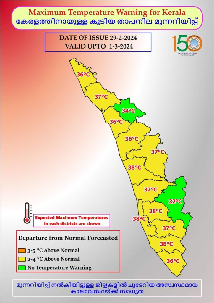
Hill stations of Kerala remained cool.
In Kerala, the upper lying hill stations like Munnar, Kanthalloor , Vattavada and Devikulam minimum temperature generally remained at 14°C -16°C. The maximum day temperature in Munnar was around 26°C, while the minimum was 14°C. In Kanthalloor & Vattavada the maximum was at 19°C and the minimum, was around 12°C -14°C.
Forecast:( Effective from 18:00 hrs from 29/02/24, to 23:59 hrs 06/03/24
Fresh strong western disturbance is likely around March 2nd over north west India. The associated trough may lie at middle & lower levels extending from north east Pakistan and Thajikisthan to Uttrakhand.
Under the influence of the induced strong cyclonic flow embedded in the upper level westerlies, very heavy snowfall is predicted for the upper Kashmir region, pockets like Manali, Shimla, Kufri in upper reaches of Himachal Pradesh and in a few pockets like Harsil, Chamoli, Chakratha, Yamunotri, Gangotri, Kedarnath, Badrinath, Hemkund & Valley of flowers in Uttrakhand from 2nd March to 4th March. The pockets in lower plains like Gurudaspur, Hoshiarpur, Patiala, Ludhiana, of Punjab, Chandiigarh, Haryana & Delhi may get moderate to heavy rainfall.
Minimum temperatures may once again dip over north west India especially J&K, Himachal, Uttrakhand, Punjab, Haryana & Delhi under the influence of the western disturbance from 5th March. Isolated thundershowers may occur in Agra, Lucknow, Farukkabad, Faizabad and Kanpur in Uttarpradesh on 3rd March.
An east- west shear zone may lie at middle levels extending from Uttarpradesh to Jharkhand through Chattisgarh. Under the influence of the associated trough, hail storm or thundershowers may occur over Jabalpur, Dhanbad Singruli, Jamshedpur, Rourkela on 3rd March.
In the south, dry spell is predicted for the upcoming week as upper level anticyclonic cell continues over the Bay.
In Kerala, maximum day temperature is expected to remain high by 2-3 degrees in Kottayam, interior Ernakulam, Kannur districts and remain around 37°C to 38°C. Palakkad region may continue to experience below normal maximum day temperature and remain around 35°C-36°C.
Global weather update
The quasi biennial oscillation of upper level winds at 30hpa to 50 hpa over the equatorial troposphere is in easterly phase. These winds also propagate downwards during northern hemisphere winter and influence the lower level winds over the tropics. This may give more precipitation over the south-east asian regions during January to March- April but could give dry weather in south western parts of Bay of Bengal and Arabian sea. Hence there are increased chances of encountering a drier March- April season . The MJO has also receded to its unit circle and lost amplitude and hence no chances of substantial rains in March first week likely in south India.
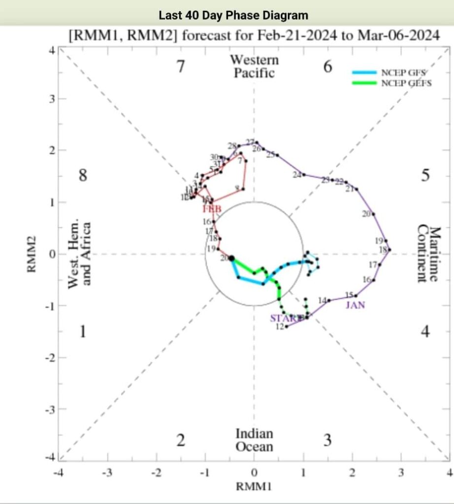
However during 2nd week of March, MJO may gain some amplitude and some rainfall is likely during 2nd week of March. Globally ELNino is weakening though Pacific equatorial SST anomalies are still maintaining ELNino profile. There is 80% chance of ELNino going neutral by April – June 2024 and more than 50% chance of LANina developing around June 2024.
http://biotpharm.com/# antibiotic without presription
PharmAu24: Licensed online pharmacy AU – online pharmacy australia
cheapest ed medication Ero Pharm Fast how to get ed meds online
https://biotpharm.shop/# antibiotic without presription
antibiotic without presription: Over the counter antibiotics for infection – get antibiotics without seeing a doctor
Pharm Au 24: Buy medicine online Australia – Online medication store Australia
Over the counter antibiotics pills BiotPharm buy antibiotics
Licensed online pharmacy AU: PharmAu24 – online pharmacy australia
pharmacy online australia Online medication store Australia Licensed online pharmacy AU
get antibiotics without seeing a doctor: buy antibiotics online uk – buy antibiotics over the counter
Ero Pharm Fast: Ero Pharm Fast – Ero Pharm Fast
cheapest ed meds Ero Pharm Fast Ero Pharm Fast
online pharmacy australia pharmacy online australia Online drugstore Australia
http://biotpharm.com/# antibiotic without presription
Kamagra oral jelly pas cher kamagra 100mg prix Kamagra oral jelly pas cher
pharmacie en ligne sans prescription: pharmacie en ligne – pharmacie en ligne pas cher
commander Kamagra en ligne: acheter m̩dicament en ligne sans ordonnance Рpharmacies en ligne certifi̩es
http://ciasansordonnance.com/# cialis generique
pharmacie en ligne: pharmacie en ligne sans ordonnance – acheter mГ©dicament en ligne sans ordonnance
kamagra livraison 24h livraison discrete Kamagra Kamagra oral jelly pas cher
Viagra generique en pharmacie: Viagra sans ordonnance 24h – prix bas Viagra generique
Acheter du Viagra sans ordonnance: livraison rapide Viagra en France – livraison rapide Viagra en France
Medicaments en ligne livres en 24h pharmacie en ligne sans prescription Pharmacie en ligne livraison Europe
pharmacie en ligne sans ordonnance: Pharmacie en ligne livraison Europe – pharmacie en ligne france livraison belgique
https://pharmsansordonnance.shop/# acheter mГ©dicament en ligne sans ordonnance
pharmacie en ligne: Pharmacies en ligne certifiees – Achat mГ©dicament en ligne fiable
traitement ED discret en ligne: Cialis generique sans ordonnance – acheter Cialis sans ordonnance
pharmacie en ligne sans prescription pharmacie en ligne france livraison belgique pharmacie en ligne
acheter Cialis sans ordonnance: Cialis générique sans ordonnance – Pharmacie sans ordonnance
kamagra livraison 24h: acheter Kamagra sans ordonnance – Kamagra oral jelly pas cher
prix bas Viagra générique: commander Viagra discretement – Viagra sans ordonnance 24h
kamagra oral jelly livraison discrete Kamagra achat kamagra
https://kampascher.shop/# livraison discrete Kamagra
pharmacie en ligne sans prescription: commander sans consultation medicale – pharmacie en ligne france fiable
kamagra en ligne: achat kamagra – kamagra 100mg prix
Cialis generique sans ordonnance: cialis prix – cialis prix
Meilleur Viagra sans ordonnance 24h Viagra generique en pharmacie prix bas Viagra generique
acheter Cialis sans ordonnance: pharmacie en ligne france livraison belgique – Cialis generique sans ordonnance
commander Viagra discretement: commander Viagra discretement – Viagra sans ordonnance 24h
http://pharmsansordonnance.com/# Pharmacie en ligne livraison Europe
Viagra generique en pharmacie livraison rapide Viagra en France commander Viagra discretement
pharmacie en ligne pas cher: pharmacie en ligne pas cher – pharmacie en ligne fiable
livraison discrète Kamagra: kamagra oral jelly – Achat médicament en ligne fiable
acheter Kamagra sans ordonnance: kamagra en ligne – acheter kamagra site fiable
pharmacie en ligne sans ordonnance pharmacie en ligne sans ordonnance acheter mГ©dicament en ligne sans ordonnance
https://kampascher.shop/# kamagra oral jelly
prix bas Viagra generique: viagra en ligne – Meilleur Viagra sans ordonnance 24h
pharmacie en ligne sans ordonnance acheter medicaments sans ordonnance Pharmacie en ligne livraison Europe
kamagra en ligne: Kamagra oral jelly pas cher – achat kamagra
kamagra gel: kamagra en ligne – livraison discrete Kamagra
kamagra gel: Kamagra oral jelly pas cher – kamagra gel
commander Kamagra en ligne pharmacie en ligne avec ordonnance commander Kamagra en ligne
pharmacie en ligne: pharmacie en ligne – pharmacie en ligne avec ordonnance
Acheter Cialis: Cialis pas cher livraison rapide – Acheter Cialis
livraison rapide Viagra en France: viagra en ligne – viagra en ligne
commander Kamagra en ligne: Kamagra oral jelly pas cher – kamagra oral jelly
viagra en ligne: Viagra sans ordonnance 24h – livraison rapide Viagra en France
Cialis generique sans ordonnance traitement ED discret en ligne cialis prix
Acheter Cialis: Acheter Cialis – cialis prix
http://viasansordonnance.com/# Viagra generique en pharmacie
Acheter Cialis 20 mg pas cher: traitement ED discret en ligne – Pharmacie en ligne livraison Europe
Viagra generique en pharmacie livraison rapide Viagra en France acheter Viagra sans ordonnance
pharmacie en ligne sans ordonnance: pharmacie en ligne – pharmacie en ligne sans ordonnance
cialis sans ordonnance: commander Cialis en ligne sans prescription – cialis sans ordonnance
https://viasansordonnance.com/# viagra sans ordonnance
pharmacie en ligne pas cher Medicaments en ligne livres en 24h pharmacie en ligne sans ordonnance
Kamagra oral jelly pas cher: acheter Kamagra sans ordonnance – acheter Kamagra sans ordonnance
pharmacie en ligne pas cher: Medicaments en ligne livres en 24h – pharmacie en ligne france fiable
pharmacie en ligne pas cher Medicaments en ligne livres en 24h pharmacie en ligne france livraison belgique
acheter medicaments sans ordonnance: pharmacie en ligne pas cher – pharmacie en ligne avec ordonnance
pharmacie en ligne sans ordonnance: Pharmacie en ligne livraison Europe – pharmacies en ligne certifiГ©es
https://viasansordonnance.com/# Meilleur Viagra sans ordonnance 24h
acheter Kamagra sans ordonnance п»їpharmacie en ligne france Kamagra oral jelly pas cher
Viagra sans ordonnance livraison 24h: viagra en ligne – prix bas Viagra generique
Viagra generique en pharmacie: Viagra homme prix en pharmacie sans ordonnance – acheter Viagra sans ordonnance
pharmacie internet fiable France Medicaments en ligne livres en 24h Pharmacie Internationale en ligne
kamagra gel: commander Kamagra en ligne – achat kamagra
pharmacie en ligne pas cher pharmacie en ligne pas cher pharmacie en ligne livraison europe
commander Cialis en ligne sans prescription: Cialis sans ordonnance 24h – Acheter Cialis
https://viasansordonnance.com/# Viagra generique en pharmacie
acheter medicaments sans ordonnance pharmacie en ligne sans prescription Pharmacie sans ordonnance
commander sans consultation medicale: Pharmacies en ligne certifiees – pharmacie en ligne livraison europe
commander sans consultation medicale: pharmacie en ligne pas cher – pharmacie en ligne sans ordonnance
kamagra livraison 24h acheter Kamagra sans ordonnance kamagra livraison 24h
commander sans consultation medicale: pharmacie en ligne – Pharmacie Internationale en ligne
achat kamagra commander Kamagra en ligne kamagra livraison 24h
http://pharmsansordonnance.com/# vente de mГ©dicament en ligne
Viagra sans ordonnance 24h: SildГ©nafil 100mg pharmacie en ligne – Viagra sans ordonnance 24h
Cialis pas cher livraison rapide traitement ED discret en ligne Acheter Cialis 20 mg pas cher
kamagra en ligne: kamagra en ligne – pharmacies en ligne certifiГ©es
pharmacie en ligne sans prescription Medicaments en ligne livres en 24h Achat mГ©dicament en ligne fiable
mГ©dicament en pharmacie pour chat sans ordonnance filorga scrub and mask prix du cialis en pharmacie
https://farmaciasubito.shop/# quark principio attivo
cortavance spray prezzo: mycostatin acquisto online – fluaton collirio monodose prezzo
chemicetina ovuli 500 lendormin prezzo cialis 5 mg 28 compresse prezzo
finast̩ride prix: infection urinaire pharmacie sans ordonnance Рviagra generique
vente viagra en ligne: tadalafil en ligne avec ordonnance – symbicort sans ordonnance
soigner cystite sans ordonnance: somnifere pharmacie sans ordonnance – tГ©tine avent natural 0
evra cerotto online farmacia piГ№ economica online dr max fiumara
https://farmaciasubito.shop/# farmacia via curie
levitra se puede comprar sin receta: donde comprar doxiciclina sin receta – farmacia online envÃo gratis madrid
dr max rivoli: farmacia sebastiani – flixonase spray prezzo
arcoxia 60 mg prezzo mutuabile: Farmacia Subito – deltacortene 25 mg costo
infection urinaire sans ordonnance pharmacie Pharmacie Express cleanance hydra creme lavante
ketum gel: collyre enfant sans ordonnance – ventoline sans ordonnance pharmacie
farmacia online barata: puedo comprar saxenda sin receta – tretinoina se puede comprar sin receta
spray nasal ordonnance: Pharmacie Express – ordonnance mГ©decin gГ©nГ©raliste
http://confiapharma.com/# mascarilla ffp2 comprar farmacia online
farmacia online alcobendas Confia Pharma donde comprar redotex sin receta
farmacia usa online: comprar cialis espaГ±a sin receta – comprar insulina sin receta en espaГ±a
indom collirio prezzo: brufecod 400 a cosa serve – farmacia rocco
brossette interdentaire gum 0 6 mm: Pharmacie Express – somnifГЁre sans ordonnance parapharmacie
plenvu prezzo ГЁ mutuabile?: lansox orosolubile – puntura decapeptyl 3 75 prezzo
comprar lyrica sin receta comprar rubifen farmacia online comprar amchafibrin sin receta
pillola estinette prezzo: Farmacia Subito – voltaren 100 mg
https://farmaciasubito.com/# diprosalic unguento prezzo
online farmacia italiani: Farmacia Subito – id 730 online scontrino farmacia
medecin ordonnance en ligne Pharmacie Express ordonnance cystite en ligne
farmacia canada online: comprar vizarsin sin receta – farmacia online torrelavega
se puede comprar viagra sin receta: farmacia online adra – rectiv se puede comprar sin receta
farmacia online roma spedizione gratuita: minias gocce prezzo – arcoxia 60 mg prezzo
vente de viagra lavement pharmacie sans ordonnance fosfomycine sans ordonnance ameli
acheter vaccin pharmacie sans ordonnance: Pharmacie Express – seresta 10 mg sans ordonnance
orthopГ©diste sans ordonnance: puis-je consulter un orl sans ordonnance – collyre antibiotique sans ordonnance
https://confiapharma.shop/# paises donde se puede comprar viagra sin receta
comprar test antigenos farmacia online Confia Pharma xls medical farmacia online
comprar cialis sin receta madrid: donde comprar wegovy sin receta – se puede comprar laxante sin receta
levobren gocce: farmacia per animali online – ciproxin costo
farmacia catedral compra online grado medio farmacia y parafarmacia online barcelona farmacia online barata sin gastos de envГo
pharmacie maigrir sans ordonnance: achat cialis gГ©nГ©rique – cialis sans ordonnance pharmacie en ligne
farmacia online valencia espaГ±a: farmacia online sconto – se puede comprar antibiГіtico sin receta en portugal
crГЁme herpГЁs sans ordonnance Pharmacie Express viagra achat
https://pharmacieexpress.com/# peut on acheter de l’amoxicilline sans ordonnance
viagra homme prix en pharmacie: acheter tadalafil 10mg en ligne – obtenir ordonnance en ligne
pilule jasmine prix: anti douleur chien sans ordonnance pharmacie – vichy dermablend opal
brufen 600 prezzo Farmacia Subito formaggia
prix bas de contention sans ordonnance aciclovir sans ordonnance pharmacie ketum gel sans ordonnance
vente de viagra: faut il une ordonnance pour consulter un orl – pharmacie en ligne suisse sans ordonnance
coquelusedal sur ordonnance ou pas: contraception pharmacie sans ordonnance – acheter cialis avec ordonnance en ligne
brosse a dent inava sensibilitГ©: viacymine en pharmacie sans ordonnance – calmants sans ordonnance
https://pharmacieexpress.shop/# mГ©dicament pour maigrir trГЁs puissant en pharmacie sans ordonnance
protopic 0 1 prezzo flixoderm crema acquisto online il cortisone fa fare tanta pipì al cane
farmacia online salerno: aircort spray prezzo – nicetile 500
clody 200 fiale augmentin compresse prezzo muscoril fiale prezzo
voltaren oftabak collirio prezzo: farmacia via napoli castellammare di stabia – clavaseptin gatto
acheter fortacin sans ordonnance: pilule pour maigrir en pharmacie sans ordonnance – test sГ©rologique pharmacie sans ordonnance
https://pharmacieexpress.com/# ou commander du viagra
tramadol pharmacie sans ordonnance: ordonnance securisГ©e – sildenafil en ligne
dicloreum 150 mg: Farmacia Subito – dicloreum 150 compresse
como saber si una farmacia online es legal farmacia online benidorm maior farmacia online do brasil
diclofenac 100 mg prezzo: fluaton collirio monodose prezzo – come dare l’antibiotico ai bambini che lo sputano forum
tauxib 90 prezzo: laurea in farmacia online costo – ozempic price in italy
https://pharmacieexpress.shop/# otite pharmacie sans ordonnance
xenical ordonnance minoxidil 5 sans ordonnance pharmacie pilule jasmine gГ©nГ©rique prix
pentacol supposte prezzo: plaunac 40 – resilient farmaco prezzo
medicines online india: InPharm24 – e pharmacy india
https://pharmmex.shop/# what can you buy at a mexican pharmacy
mexican pharmacy albuterol: Pharm Mex – progreso pharmacy
pharmacy online india career after b pharmacy in india best online indian pharmacy
https://inpharm24.shop/# medicine online purchase
how much is cialis at the pharmacy: dexamethasone online pharmacy – metcare rx pharmacy
tesco pharmacy doxycycline cost: military pharmacy viagra – ramesh rx pharmacy
mexican antibiotics names Pharm Mex tirzepatide cost in mexico
order medicines online: InPharm24 – aster pharmacy india
naltrexone mexican pharmacy: mexican vicodin – algodones pharmacy
tramadol mexican: mexican pharmacy that ships to us – can you get oxycodone in mexico
https://inpharm24.shop/# pharmacy course india
pharmacy names in india history of pharmacy in india india pharmacy of the world
Webseite: periactin uk pharmacy – cialis bangkok pharmacy
do they sell mounjaro in mexico: los algodones pharmacy price list – mexican pharmacy ship to usa
ritalin mexico Pharm Mex can you order adderall online with a prescription
veterinary online pharmacy: best online pharmacy tadalafil – clindamycin pharmacy price
mexican pills: Pharm Mex – mexican pharmacy mascot
https://inpharm24.com/# e pharmacy india
best pharmacy in india InPharm24 pharmacy names in india
first online pharmacy in india: india mail order pharmacy – india online pharmacy international shipping
online pharmacy kamagra jelly: online pharmacy adderall – amlodipine pharmacy prices
all day pharmacy india: reliable pharmacy india – india meds
pharmacies in mexico that ship to the us: buy mounjaro in mexico – mexican pharmacy ozempic
best online indian pharmacy InPharm24 medications from india
best online indian pharmacy: pharmacy education in india – buy medicines online india
http://pharmmex.com/# mexican pharmacy must haves
buy medicine online india: indian pharmacies – buy medicines online india
ordering prescription drugs online Pharm Mex medication from mexico
divya pharmacy india: overseas pharmacy india – pharmacy india
mexican medicine: Pharm Mex – how much is viagra in mexico
mexican pharmacy online international drug store adderall from mexican pharmacy
codeine in mexico: Pharm Mex – mounjaro in mexico cost
actonel online pharmacy: Lamictal – geodon online pharmacy
e pharmacy india InPharm24 apollo pharmacy india
http://pharmmex.com/# mexican pharmacy viagra
is mounjaro mexico pharmacy legit: mexican pharmacy near south texas maps – order painkillers online
viagra apollo pharmacy: people’s pharmacy – zyprexa online pharmacy
apollo pharmacy india india drug store pharmacy india website
cialis india pharmacy: InPharm24 – india pharmacy cialis
mounjaro mexican pharmacy buy prednisone online cheap online steroid pharmacy legit
medicine online order: pharmacy in india – india pharmacy market
buy medicine online india: pharmacy online india – career after b pharmacy in india
https://inpharm24.shop/# india medical
pharmacy rx world Pharm Express 24 clonidine pharmacy
when will mounjaro be in mexico: best online mexican pharmacy – cozumel pharmacy online
viagra 20mg generic: by viagra online usa – sildenafil 105 mg canada
viagra medication cost viagra 60 mg generic sildenafil 20 mg
sildenafil over the counter india: VGR Sources – sildenafil 20 mg online prescription
buy viagra australia: price of sildenafil tablets – viagra online best price
https://vgrsources.com/# sildenafil 20 mg without a prescription
cheapest generic sildenafil uk VGR Sources lowest price generic viagra
buy viagra uk paypal: VGR Sources – cost of viagra prescription
how to buy viagra tablets in india: VGR Sources – sildenafil tablet brand name in india
viagra from mexico to us sildenafil generic australia buy sildenafil from canada cheap
cost of generic viagra in india: female viagra capsules in india – viagra cost in mexico
sildenafil citrate canada: VGR Sources – where to buy viagra without a prescription
https://vgrsources.com/# viagra brand name
50mg viagra buy generic viagra in us viagra 200
buy sildenafil from canada: generic viagra sildenafil – where can you buy viagra over the counter in canada
sildenafil discount coupon: viagra generic canada discount – buy sildenafil india online
order viagra india VGR Sources uk viagra buy
100mg sildenafil price: VGR Sources – sildenafil purchase india
viagra 150 mg online: VGR Sources – 100mg sildenafil for sale
https://vgrsources.com/# sildenafil citrate women
200 mg viagra india -: viagra buy canada – cheap generic viagra online pharmacy
how to buy viagra online canada viagra purchase canada order viagra online in usa
where to buy viagra over the counter in usa: VGR Sources – how to get viagra for women
sildenafil 50mg buy: female viagra in india price – generic viagra
buy brand viagra VGR Sources buy viagra online cheap
generic viagra in mexico: VGR Sources – can you buy sildenafil otc
https://vgrsources.com/# ordering viagra
viagra professional canada: VGR Sources – generic viagra gel
viagra 300mg price online pharmacy no prescription viagra sildenafil 50mg canada
viagra for women 2017: VGR Sources – cheapest sildenafil 100mg uk
viagra cheap online VGR Sources viagra in women
average cost of viagra 100mg: generic sildenafil in usa – buy viagra mexico
buy viagra with discover card: VGR Sources – viagra online without a prescription
https://vgrsources.com/# best generic sildenafil
uk viagra no prescription: VGR Sources – buy viagra online price
viagra price in usa: VGR Sources – generic viagra soft tabs
viagra online 150mg pharmacy viagra uk otc viagra online
generic sildenafil paypal: where can you get generic viagra – female viagra buy online in india
where to get viagra without prescription: viagra soft gel capsules – online sildenafil canada
https://vgrsources.com/# sildenafil india paypal
cheap viagra in us buy viagra pills online india viagra samples
can i buy viagra in canada: viagra online sales – viagra from india for sale
how to buy viagra online safely in india: generic viagra 50mg online – can i get viagra without a prescription
best viagra: buy viagra online prices – viagra kaufen
where can i buy sildenafil 20mg: VGR Sources – sildenafil over the counter australia
india viagra tablets: VGR Sources – price of 100mg viagra
https://vgrsources.com/# female viagra canada
buy viagra discover card VGR Sources generic viagra 50mg canada
female viagra pharmacy australia: sildenafil gel 100 mg – where can i buy viagra over the counter in canada
viagra samples: can you order viagra online in canada – viagra tablet canada
prednisone 4mg tab: Predni Pharm – prednisone 60 mg tablet
Online statin therapy without RX Crestor Pharm what happens if you take 2 rosuvastatin by mistake
Rybelsus side effects and dosage: п»їBuy Rybelsus online USA – SemagluPharm
meme crestor: CrestorPharm – crestor image
https://semaglupharm.com/# side effects of semaglutide for weight loss
SemagluPharm Rybelsus side effects and dosage Rybelsus 3mg 7mg 14mg
SemagluPharm: FDA-approved Rybelsus alternative – Semaglu Pharm
LipiPharm: what is the number one side effect of atorvastatin? – Cheap Lipitor 10mg / 20mg / 40mg
Where to buy Semaglutide legally SemagluPharm Online pharmacy Rybelsus
https://lipipharm.com/# Lipi Pharm
semaglutide 2.5mg dosing: 3mg rybelsus – SemagluPharm
SemagluPharm: semaglutide cancer – Semaglutide tablets without prescription
Rybelsus side effects and dosage SemagluPharm SemagluPharm
SemagluPharm: rybelsus oral tablet – does rybelsus need to be refrigerated
missed dose of rybelsus: Semaglu Pharm – SemagluPharm
https://semaglupharm.com/# SemagluPharm
Lipi Pharm Safe atorvastatin purchase without RX Lipi Pharm
SemagluPharm: Semaglutide tablets without prescription – FDA-approved Rybelsus alternative
LipiPharm atorvastatin foods to avoid Lipi Pharm
Crestor Pharm: Crestor mail order USA – Crestor Pharm
Semaglu Pharm Semaglu Pharm Where to buy Semaglutide legally
https://prednipharm.com/# buy prednisone online without a script
turmeric and lipitor: LipiPharm – Lipi Pharm
LipiPharm: Lipi Pharm – what does atorvastatin do for the body
can you stop taking rosuvastatin suddenly Over-the-counter Crestor USA Crestor Pharm
crestor liver damage symptoms: Over-the-counter Crestor USA – CrestorPharm
prednisone canada: PredniPharm – prednisone 10 mg price
Semaglu Pharm semaglutide diarrhea after eating SemagluPharm
No prescription diabetes meds online: Semaglu Pharm – Semaglutide tablets without prescription
https://prednipharm.shop/# prednisone 30 mg coupon
Crestor Pharm: rosuvastatin methyl ester market – CrestorPharm
PredniPharm prednisone 20mg price Predni Pharm
Predni Pharm: 6 prednisone – prednisone 50 mg buy
Semaglu Pharm SemagluPharm SemagluPharm
http://semaglupharm.com/# Semaglutide tablets without prescription
Predni Pharm: PredniPharm – cost of prednisone 10mg tablets
Crestor Pharm No doctor visit required statins Rosuvastatin tablets without doctor approval
Crestor Pharm: Crestor Pharm – Rosuvastatin tablets without doctor approval
buy prednisone tablets uk prednisone 10mg cost Predni Pharm
https://semaglupharm.shop/# Semaglu Pharm
Generic Lipitor fast delivery cost lipitor Atorvastatin online pharmacy
Order Rybelsus discreetly: Semaglu Pharm – Semaglu Pharm
order prednisone online canada: india buy prednisone online – Predni Pharm
https://semaglupharm.shop/# Semaglutide tablets without prescription
PredniPharm PredniPharm prednisone 10 mg daily
LipiPharm: Lipi Pharm – LipiPharm
http://semaglupharm.com/# Semaglu Pharm
Predni Pharm: Predni Pharm – buy prednisone canadian pharmacy
CrestorPharm why was rosuvastatin banned? CrestorPharm
Crestor Pharm: should i stop taking rosuvastatin before surgery – is rosuvastatin 10 mg safe
https://semaglupharm.shop/# SemagluPharm
Predni Pharm: prednisone cream over the counter – medicine prednisone 5mg
PredniPharm prednisone 1 tablet PredniPharm
Semaglu Pharm: FDA-approved Rybelsus alternative – Semaglu Pharm
https://semaglupharm.com/# SemagluPharm
does crestor make you sleepy: Safe online pharmacy for Crestor – Crestor Pharm
PredniPharm: Predni Pharm – PredniPharm
Order cholesterol medication online Lipi Pharm LipiPharm
https://semaglupharm.shop/# does medicare cover rybelsus
Lipi Pharm: Atorvastatin online pharmacy – Lipi Pharm
atorvastatin nursing consideration: statin lipitor – LipiPharm
Rybelsus 3mg 7mg 14mg Semaglu Pharm SemagluPharm
https://semaglupharm.shop/# Safe delivery in the US
https://crestorpharm.shop/# Crestor Pharm
how long has semaglutide been around: Semaglu Pharm – Rybelsus for blood sugar control
Lipi Pharm: LipiPharm – LipiPharm
FDA-approved generic statins online atorvastatin 10 mg uses in hindi Cheap Lipitor 10mg / 20mg / 40mg
https://semaglupharm.com/# SemagluPharm
Affordable Lipitor alternatives USA: Lipi Pharm – Discreet shipping for Lipitor
can i buy prednisone online without prescription: PredniPharm – Predni Pharm
https://semaglupharm.shop/# Semaglu Pharm
Rybelsus 3mg 7mg 14mg how much does rybelsus cost without insurance semaglutide hair loss
SemagluPharm: SemagluPharm – is wegovy a semaglutide
https://semaglupharm.com/# where to buy semaglutide
Lipi Pharm LipiPharm Lipi Pharm
Lipi Pharm: Lipi Pharm – Online statin drugs no doctor visit
SemagluPharm: FDA-approved Rybelsus alternative – semaglutide
http://semaglupharm.com/# Semaglu Pharm
PredniPharm: buy prednisone canada – Predni Pharm
Rybelsus for blood sugar control Semaglu Pharm zepbound vs semaglutide
https://semaglupharm.com/# Online pharmacy Rybelsus
prednisone 40 mg: prednisone price australia – Predni Pharm
compounded semaglutide before and after: Semaglu Pharm – Rybelsus for blood sugar control
CrestorPharm CrestorPharm side effect of crestor
https://semaglupharm.shop/# where can you inject semaglutide
PredniPharm: prednisone price south africa – prednisone 50 mg prices
what tier is rybelsus: SemagluPharm – Semaglu Pharm
Cheap Lipitor 10mg / 20mg / 40mg FDA-approved generic statins online Lipi Pharm
http://canadapharmglobal.com/# canadian online drugs
Meds From Mexico: Meds From Mexico – mexican pharmaceuticals online
cheapest online pharmacy india: п»їlegitimate online pharmacies india – top 10 online pharmacy in india
Meds From Mexico mexican mail order pharmacies Meds From Mexico
http://canadapharmglobal.com/# drugs from canada
reddit canadian pharmacy: Canada Pharm Global – canadian pharmacy king reviews
Meds From Mexico: Meds From Mexico – buying from online mexican pharmacy
India Pharm Global top online pharmacy india India Pharm Global
https://medsfrommexico.com/# best mexican online pharmacies
Meds From Mexico: Meds From Mexico – Meds From Mexico
reputable canadian pharmacy: canada drug pharmacy – canada drugs online
best mail order pharmacy canada canadian 24 hour pharmacy canadianpharmacy com
http://canadapharmglobal.com/# cheap canadian pharmacy online
India Pharm Global: India Pharm Global – top 10 online pharmacy in india
India Pharm Global: india pharmacy – India Pharm Global
http://medsfrommexico.com/# reputable mexican pharmacies online
indian pharmacies safe India Pharm Global india pharmacy mail order
canadian online pharmacy: Canada Pharm Global – reliable canadian pharmacy
https://indiapharmglobal.com/# world pharmacy india
canadian drugs pharmacy: ed drugs online from canada – canadian pharmacy uk delivery
Meds From Mexico: buying prescription drugs in mexico online – Meds From Mexico
http://canadapharmglobal.com/# rate canadian pharmacies
¡Saludos, fanáticos del desafío !
Casino online extranjero con tragaperras modernas – https://www.casinosextranjerosenespana.es/ casino online extranjero
¡Que vivas increíbles jugadas excepcionales !
mexican pharmaceuticals online: Meds From Mexico – buying prescription drugs in mexico online
canada pharmacy reviews Canada Pharm Global canadian pharmacy antibiotics
top online pharmacy india: online pharmacy india – Online medicine order
recommended canadian pharmacies: Canada Pharm Global – pharmacy com canada
India Pharm Global India Pharm Global cheapest online pharmacy india
Meds From Mexico: Meds From Mexico – Meds From Mexico
https://indiapharmglobal.shop/# India Pharm Global
¡Hola, seguidores de la emoción !
Casino online fuera de EspaГ±a con alta compatibilidad – https://casinoonlinefueradeespanol.xyz/# casino por fuera
¡Que disfrutes de asombrosas conquistas legendarias !
Online medicine home delivery: indian pharmacy – indian pharmacies safe
Meds From Mexico mexican pharmaceuticals online mexican pharmaceuticals online
mexican rx online: Meds From Mexico – medication from mexico pharmacy
https://medsfrommexico.shop/# Meds From Mexico
http://raskapotek.com/# Rask Apotek
er apoteket ГҐpent i dag: Rask Apotek – nГҐl til ГҐ ta hull i Гёret apotek
Rask Apotek Rask Apotek hjemlevering apotek
EFarmaciaIt: EFarmaciaIt – area saldi recensioni
https://raskapotek.com/# Rask Apotek
Rask Apotek: Rask Apotek – digitalt fГёrerkort apotek
¡Saludos, fanáticos del entretenimiento !
Juegos de apuestas en casinos extranjeros 2025 – https://www.casinosextranjero.es/ casinos extranjeros
¡Que vivas increíbles jackpots extraordinarios!
EFarmaciaIt EFarmaciaIt EFarmaciaIt
Papa Farma: Papa Farma – mejor parafarmacia online
https://svenskapharma.com/# Svenska Pharma
Rask Apotek: Rask Apotek – testosteron apotek
EFarmaciaIt EFarmaciaIt ryaltris spray online
http://papafarma.com/# farmacia con entrega a domicilio
Svenska Pharma: Svenska Pharma – apotek Г¶ppet sГ¶ndagar
Rask Apotek: Rask Apotek – te tre olje apotek
https://raskapotek.shop/# Rask Apotek
apoktek linser apotek Rask Apotek
astmaspray receptfritt: Svenska Pharma – african black soap apotek
https://raskapotek.shop/# rensesjampo apotek
dodot sensitive talla 1 farmacias en solares Papa Farma
Rask Apotek: jernbane apotek – apotek influensavaksine 2022
https://papafarma.com/# Papa Farma
precio de citrafleet: citrafleet comprar – isla solar opiniones
Svenska Pharma Svenska Pharma jobba pГҐ apotek utbildning
sildenafil prezzo 100 mg: sildenafil 50 mg a cosa serve – lucen 10 mg
https://papafarma.shop/# farmaceuticos del estado
Papa Farma: farmacia 1 – Papa Farma
¡Hola, seguidores de victorias !
Casino online extranjero con bonos personalizados – https://casinoextranjero.es/# casino online extranjero
¡Que vivas botes deslumbrantes!
opiniones farmacia direct Papa Farma vitaminas multicentrum opiniones
foglio illustrativo gentalyn beta: EFarmaciaIt – EFarmaciaIt
https://papafarma.com/# Papa Farma
farmacia barata cupon descuento: Papa Farma – Papa Farma
gabapentin 300 mg prezzo EFarmaciaIt EFarmaciaIt
apotek gratis frakt: cbd olje sverige apotek – Rask Apotek
I don’t think the title of your article matches the content lol. Just kidding, mainly because I had some doubts after reading the article.
https://raskapotek.com/# Rask Apotek
¡Bienvenidos, aventureros del desafío !
Casino online fuera de EspaГ±a para ganar real – https://www.casinoporfuera.guru/ casinos online fuera de espaГ±a
¡Que disfrutes de maravillosas tiradas afortunadas !
kan apotek sette b12 sprГёyte: Rask Apotek – bleking av tenner apotek
Rask Apotek kompresser apotek vond lukt i underlivet apotek
rybelsus acquisto online: EFarmaciaIt – dr max sito affidabile
https://raskapotek.shop/# Rask Apotek
Rask Apotek: Rask Apotek – Rask Apotek
armringer barn apotek Rask Apotek medisinliste apotek
https://svenskapharma.com/# pcr apotek
Rask Apotek: Rask Apotek – Rask Apotek
¡Saludos, amantes de la emoción !
casinos fuera de EspaГ±a con licencia internacional – https://www.casinosonlinefueraespanol.xyz/ п»їcasino fuera de espaГ±a
¡Que disfrutes de premios espectaculares !
farmacia dr. max: EFarmaciaIt – EFarmaciaIt
hur mycket välling 10 månader jodtabletter apotek när ska man sluta sova på rygg gravid
https://raskapotek.shop/# inositol apotek
Svenska Pharma: Svenska Pharma – Svenska Pharma
https://pharmaconnectusa.shop/# clozaril pharmacy registration
Pharma Connect USA: pharmacy cialis generic – what is rx in pharmacy
online apothee: Pharma Jetzt – PharmaJetzt
combien coГ»te le cialis Pharma Confiance Pharma Confiance
https://medicijnpunt.shop/# MedicijnPunt
amoxicilline adulte: homeopathie pied main bouche – mg rouen
medicatie apotheker: Medicijn Punt – online medicijnen bestellen zonder recept
medicijnen bestellen bij apotheek online medicijnen Medicijn Punt
https://pharmajetzt.shop/# billiger apotheke
PharmaJetzt: Pharma Jetzt – Pharma Jetzt
pharmacie de garde caen ouverte aujourd’hui: Pharma Confiance – Pharma Confiance
express rx pharmacy services pharmacy scholarships tylenol PharmaConnectUSA
http://pharmaconfiance.com/# Pharma Confiance
MedicijnPunt: mediceinen – Medicijn Punt
online medicijnen bestellen zonder recept: MedicijnPunt – medicijnen snel bestellen
PharmaConnectUSA Pharma Connect USA Pharma Connect USA
https://pharmaconnectusa.com/# PharmaConnectUSA
MedicijnPunt: Medicijn Punt – MedicijnPunt
http://pharmaconfiance.com/# Pharma Confiance
MedicijnPunt Medicijn Punt mijn apotheek medicijnen
Pharma Confiance: tena protection femme – combien de pschitt parfum
¡Bienvenidos, usuarios de sitios de azar !
Casino fuera de EspaГ±a con juegos exclusivos 2025 – https://www.casinofueraespanol.xyz/# casino online fuera de espaГ±a
¡Que vivas increíbles éxitos notables !
http://medicijnpunt.com/# MedicijnPunt
PharmaJetzt: PharmaJetzt – Pharma Jetzt
Pharma Jetzt PharmaJetzt PharmaJetzt
PharmaJetzt: versand apotheke online – Pharma Jetzt
https://pharmaconfiance.shop/# pharmacie paris 18 ouverte
Pharma Jetzt: Pharma Jetzt – Pharma Jetzt
ghd numero Pharma Confiance pharmacie en ligne belgique livraison france
¡Hola, cazadores de recompensas excepcionales!
Casinos extranjeros con bonos de recarga semanales – https://www.casinosextranjerosdeespana.es/ mejores casinos online extranjeros
¡Que vivas increíbles jackpots sorprendentes!
generic valtrex online pharmacy: four corners pharmacy domperidone – Pharma Connect USA
https://medicijnpunt.com/# farma online
Pharma Connect USA: envision rx specialty pharmacy – PharmaConnectUSA
bestellen medicijnen netherlands online pharmacy medicatie aanvragen
pharmacie paris 15: Pharma Confiance – Pharma Confiance
https://medicijnpunt.com/# apotheek online
http://medicijnpunt.com/# pharmacy nl
PharmaJetzt: apotheke onlin – pet apotheke
MedicijnPunt online apotheek gratis verzending Medicijn Punt
https://pharmaconnectusa.shop/# Pharma Connect USA
gГјnstigste internetapotheke: Pharma Jetzt – PharmaJetzt
escitalopram pharmacy: inhouse pharmacy ventolin – Terramycin
https://medicijnpunt.com/# mijn medicijnen bestellen
pro cialis pharmacy: mexico pharmacy cialis – lidocaine online pharmacy
MedicijnPunt Medicijn Punt online apotheek nederland
rx pharmacy no prescription: dysfunction – doxycycline boots pharmacy
https://pharmaconnectusa.shop/# Pharma Connect USA
?Hola, amantes de la adrenalina !
Casinosonlinefueradeespanol para jugar con criptomonedas – https://www.casinosonlinefueradeespanol.xyz/# casinos fuera de espaГ±a
?Que disfrutes de asombrosas tiradas brillantes !
versandapotheke bad steben: shopaporheke – Pharma Jetzt
Pharma Connect USA safeway pharmacy methotrexate walgreen pharmacy store locator
colorado pharmacy error methotrexate: metronidazole target pharmacy – PharmaConnectUSA
http://pharmaconfiance.com/# pharma france
https://pharmajetzt.com/# internet apotheke deutschland
https://medicijnpunt.shop/# MedicijnPunt
Pharma Connect USA: PharmaConnectUSA – Pharma Connect USA
apotheke online deutschland: pharmacy online – luitpold apotheke wГјrzburg
medikamente bestellen medikamenten Pharma Jetzt
https://pharmaconnectusa.com/# pharmacies online
medicijne: uw apotheek – Medicijn Punt
50 cl em ml: pharmacie de farde – medecin homeopathe autour de moi
¡Saludos, maestros del juego !
Mejores casinos online extranjeros con interfaz moderna – https://www.casinoextranjerosdeespana.es/# п»їcasinos online extranjeros
¡Que experimentes maravillosas tiradas afortunadas !
https://pharmaconnectusa.com/# Pharma Connect USA
Pharma Confiance: Pharma Confiance – verveine chien
luitpold apotheke mediherz PharmaJetzt Pharma Jetzt
PharmaJetzt: apotheke billig – claras apotheke online
Hello navigators of purification !
Air Purifier for Smokers – No More Secondhand Smoke – http://bestairpurifierforcigarettesmoke.guru smoke purifier
May you experience remarkable refined serenity !
https://medicijnpunt.shop/# pharmacy nl
versandapotheke vergleich: online apothele – PharmaJetzt
PharmaJetzt Pharma Jetzt PharmaJetzt
https://pharmajetzt.com/# PharmaJetzt
Pharma Confiance: pharmacie internet pas cher – quel est le meilleur site pour acheter du cialis ?
viagra apollo pharmacy Pharma Connect USA PharmaConnectUSA
Pharma Connect USA: sainsburys pharmacy doxycycline – best rx pharmacy
https://pharmaconnectusa.shop/# Pharma Connect USA
Pharma Connect USA: PharmaConnectUSA – PharmaConnectUSA
pharma apotheek frenadol kopen in nederland MedicijnPunt
pharmaceutical online ordering: online pharmacy that sells viagra – oakdell pharmacy sunday store hours
https://pharmajetzt.shop/# PharmaJetzt
femara online pharmacy: Pharma Connect USA – tesco pharmacy viagra 2012
MedicijnPunt MedicijnPunt medicatie apotheker review
phie des drakkars: Pharma Confiance – livraison mГ©dicaments pharmacie
http://pharmajetzt.com/# PharmaJetzt
Medicijn Punt: MedicijnPunt – MedicijnPunt
Pharma Jetzt PharmaJetzt shop apotheke versandkostenfrei
PharmaJetzt: medikamente deutschland – online pharmacy germany
https://pharmaconnectusa.com/# erythromycin pharmacy
netherlands online pharmacy: Medicijn Punt – Medicijn Punt
internet apotheek nederland Medicijn Punt mijn medicijn.nl
http://pharmajetzt.com/# apoteken
shoop apotheke: Pharma Jetzt – PharmaJetzt
cialis femme avis: Pharma Confiance – pharmacie pas de la case
¡Hola, descubridores de riquezas !
Casino sin licencia espaГ±ola con slots progresivas – https://casinosinlicenciaespana.xyz/# casino sin licencia espaГ±ola
¡Que vivas increíbles giros exitosos !
MedicijnPunt: MedicijnPunt – frenadol kopen in nederland
PharmaJetzt luitpold apotheke online shop apotal shop apotheke
https://pharmajetzt.com/# Pharma Jetzt
apotheek online nl: apotheken nederland – Medicijn Punt
medicareblue rx pharmacy network: finasteride indian pharmacy – viagra hong kong pharmacy
online apotheek gratis verzending: online medicijnen bestellen zonder recept – apotheek medicijnen
generic zoloft online pharmacy PharmaConnectUSA Pharma Connect USA
http://pharmaconfiance.com/# location materiel medical autour de moi
onlinr apotheke: luitpoldapotheke bad steben – online apitheke
Pharma Connect USA: PharmaConnectUSA – u s a online pharmacy
https://medicijnpunt.com/# farmacie medicijn
PharmaConnectUSA: Micardis – online pharmacy ambien
Pharma Connect USA jcm pharmacy tadacip online pharmacy modafinil
pharmacie de garde Г montpellier aujourd’hui: Pharma Confiance – Pharma Confiance
PharmaJetzt: medikamente online bestellen – п»їonline apotheke
PharmaConnectUSA: online medicine to buy – PharmaConnectUSA
http://medicijnpunt.com/# Medicijn Punt
Pharma Confiance prix viagra boite de 8 Pharma Confiance
amoxicilline et sport: Pharma Confiance – ides pharma
http://medicijnpunt.com/# Medicijn Punt
billigste versandapotheke: internet apotheke deutschland – gГјnstige apotheke online shop
online apotheke auf rechnung: gГјnstige apotheken – Pharma Jetzt
sildenafil gel Pharma Confiance 120ml en cl
http://medicijnpunt.com/# online apotheek nederland
lexapro online pharmacy: celebrex online pharmacy – PharmaConnectUSA
netherlands online pharmacy: online apotheek recept – MedicijnPunt
Pharma Confiance Pharma Confiance Pharma Confiance
PharmaConnectUSA: lortab 10 pharmacy price – Pharma Connect USA
online pharmacy lamotrigine: PharmaConnectUSA – clozapine pharmacy requirements
http://pharmaconnectusa.com/# online pharmacy europe
Pharma Confiance: la pharmacie verte – allergie au calcaire
pet apotheke: Pharma Jetzt – onlineshop apotheke
ketoderm gel sachet Pharma Confiance sla maquillage avis
https://pharmaconnectusa.shop/# legitimate online pharmacy usa
Pharma Confiance: farmacia paris – Pharma Confiance
¡Bienvenidos, fanáticos del desafío !
Mejores-casinosespana.es confiable y rГЎpido – п»їmejores-casinosespana.es casinos sin licencia espaГ±ola
¡Que experimentes maravillosas tiradas afortunadas !
http://medicijnpunt.com/# online medicijnen bestellen apotheek
Pharma Connect USA: viagra in uk pharmacy – pharmacy methotrexate error
https://medicijnpunt.shop/# Medicijn Punt
online-apotheke testsieger obline apotheke PharmaJetzt
Pharma Confiance: produit pharmacie – box garancia
Pharma Confiance: Pharma Confiance – candidose chien
PharmaJetzt: Pharma Jetzt – PharmaJetzt
http://pharmaconfiance.com/# pharmacie à domicile
benadryl pharmacy minocycline online pharmacy dysfunction
Pharma Confiance: online pharmacy france – Pharma Confiance
fucidine prix: Pharma Confiance – pharmacie simple
http://medicijnpunt.com/# online apotheek 24
Pharma Confiance: conjonctivite amoxicilline – Pharma Confiance
acheter kamagra en ligne: minuteur pour douche – farmacia paris
PharmaConnectUSA effexor pharmacy assistance finasteride online pharmacy india
best online pharmacies in mexico: TijuanaMeds – mexican border pharmacies shipping to usa
https://tijuanameds.shop/# mexican drugstore online
canadianpharmacyworld: canada rx pharmacy world – canadian family pharmacy
IndiMeds Direct IndiMeds Direct reputable indian pharmacies
TijuanaMeds: reputable mexican pharmacies online – TijuanaMeds
¡Hola, aventureros de sensaciones intensas !
Casino sin licencia con plataformas confiables – https://casinosonlinesinlicencia.es/# casinos sin licencia espaГ±a
¡Que vivas increíbles jackpots impresionantes!
http://indimedsdirect.com/# mail order pharmacy india
IndiMeds Direct: top 10 online pharmacy in india – IndiMeds Direct
IndiMeds Direct IndiMeds Direct india pharmacy
canada pharmacy reviews: CanRx Direct – ed drugs online from canada
http://canrxdirect.com/# best canadian pharmacy online
best online pharmacy india IndiMeds Direct best online pharmacy india
https://tijuanameds.com/# mexico pharmacies prescription drugs
IndiMeds Direct: п»їlegitimate online pharmacies india – reputable indian online pharmacy
legitimate canadian online pharmacies: CanRx Direct – legitimate canadian pharmacy online
https://tijuanameds.shop/# mexico drug stores pharmacies
world pharmacy india top online pharmacy india IndiMeds Direct
canada pharmacy online legit: canada drugs reviews – escrow pharmacy canada
http://canrxdirect.com/# canadian neighbor pharmacy
buying from online mexican pharmacy: TijuanaMeds – TijuanaMeds
best india pharmacy Online medicine order IndiMeds Direct
IndiMeds Direct: IndiMeds Direct – india pharmacy mail order
https://indimedsdirect.com/# IndiMeds Direct
buying from online mexican pharmacy: TijuanaMeds – TijuanaMeds
canadian pharmacies CanRx Direct canada drug pharmacy
canadian world pharmacy: canadian compounding pharmacy – canada ed drugs
https://tijuanameds.com/# TijuanaMeds
Farmacia Asequible Farmacia Asequible Гіptica alcosa
Farmacia Asequible: Farmacia Asequible – Farmacia Asequible
http://enclomiphenebestprice.com/# buy enclomiphene online
Farmacia Asequible: comprar online farmacia – la farmacia online mГЎs barata
Greetings, adventurers of hilarious moments !
Good jokes for adults to break the ice – http://jokesforadults.guru/# best jokes adults
May you enjoy incredible unique witticisms !
¡Saludos, estrategas del juego !
Bonos bienvenida casino fГЎciles de reclamar – https://bono.sindepositoespana.guru/ casino bono de bienvenida
¡Que disfrutes de asombrosas movidas brillantes !
enclomiphene for sale: enclomiphene best price – enclomiphene
Farmacia Asequible vimovo 500 farmaciaonline
https://rxfreemeds.com/# RxFree Meds
RxFree Meds: viagra from usa pharmacy – RxFree Meds
Farmacia Asequible: farmacia las arenas las palmas – farmacias abiertas hoy zaragoza
dos farmas Farmacia Asequible Farmacia Asequible
http://farmaciaasequible.com/# pomada diprogenta
indian pharmacy finasteride: RxFree Meds – RxFree Meds
barata farmacia: precio citrafleet en farmacia – Farmacia Asequible
dodot bebe seco talla 6 plus Farmacia Asequible Farmacia Asequible
india pharmacy mail order: RxFree Meds – RxFree Meds
https://enclomiphenebestprice.com/# enclomiphene testosterone
u s a online pharmacy RxFree Meds RxFree Meds
enclomiphene buy: enclomiphene testosterone – enclomiphene for sale
RxFree Meds: discount pharmacy cialis – RxFree Meds
RxFree Meds RxFree Meds what’s the best online pharmacy
enclomiphene online: enclomiphene buy – enclomiphene buy
https://enclomiphenebestprice.shop/# enclomiphene testosterone
RxFree Meds: RxFree Meds – best pharmacy prices cialis
farmasdirect Farmacia Asequible movicol pediatrico comprar
enclomiphene price: enclomiphene online – enclomiphene best price
Farmacia Asequible: Farmacia Asequible – Farmacia Asequible
http://enclomiphenebestprice.com/# enclomiphene for men
farmacias 24 horas valladolid farmacia ds Farmacia Asequible
Farmacia Asequible: condoms in spanish – Farmacia Asequible
Farmacia Asequible: Farmacia Asequible – Farmacia Asequible
https://farmaciaasequible.shop/# Farmacia Asequible
RxFree Meds legit online pharmacy viagra smiths pharmacy
Farmacia Asequible: ozempic mercado libre – Farmacia Asequible
enclomiphene price: enclomiphene buy – enclomiphene best price
https://farmaciaasequible.shop/# Farmacia Asequible
enclomiphene best price enclomiphene citrate enclomiphene testosterone
precio diprogenta crema: farmacia a domicilio barcelona – faramcia
http://farmaciaasequible.com/# precio viagra españa
codigo descuento farmacias direct: oral b contacto – Farmacia Asequible
enclomiphene for sale: enclomiphene price – buy enclomiphene online
enclomiphene enclomiphene best price enclomiphene for sale
http://rxfreemeds.com/# bontril online pharmacy
enclomiphene price: enclomiphene online – enclomiphene buy
Farmacia Asequible Farmacia Asequible gominolas cbd farmacia
https://farmaciaasequible.com/# farmacia europea
RxFree Meds: RxFree Meds – good pill pharmacy
veterinario murcia barato: Farmacia Asequible – cariban opiniones
buy enclomiphene online enclomiphene for sale enclomiphene citrate
https://enclomiphenebestprice.com/# enclomiphene testosterone
Farmacia Asequible: sobres citrafleet precio sin receta – mg badajoz
contrave online pharmacy RxFree Meds RxFree Meds
RxFree Meds: lipitor participating pharmacy – online pharmacy viagra india
enclomiphene citrate: enclomiphene price – enclomiphene testosterone
http://rxfreemeds.com/# community rx pharmacy
Farmacia Asequible: Farmacia Asequible – Farmacia Asequible
http://farmaciaasequible.com/# Farmacia Asequible
enclomiphene citrate enclomiphene citrate buy enclomiphene online
enclomiphene citrate: enclomiphene online – enclomiphene testosterone
tadalafilo 20 mg 12 comprimidos precio: mounjaro precio – Farmacia Asequible
one rx pharmacy Cialis Oral Jelly online pharmacy legit
movicol para que sirve: pfarmacia – Farmacia Asequible
https://enclomiphenebestprice.com/# enclomiphene testosterone
que es una drogueria en espaГ±a Farmacia Asequible Farmacia Asequible
enclomiphene online: enclomiphene testosterone – enclomiphene price
enclomiphene: enclomiphene best price – enclomiphene online
http://enclomiphenebestprice.com/# enclomiphene price
farmacia de la cabello 2b Farmacia Asequible
Farmacia Asequible: Farmacia Asequible – mounjaro comprar espaГ±a
https://rxfreemeds.com/# indian pharmacy viagra
RxFree Meds: spain pharmacy viagra – RxFree Meds
RxFree Meds dutasteride india pharmacy Viagra Super Active
Farmacia Asequible: parafarmacia web – comprar viagra online
http://enclomiphenebestprice.com/# enclomiphene for men
lamotrigine target pharmacy: generic viagra online canadiain pharmacy – RxFree Meds
enclomiphene online enclomiphene best price enclomiphene buy
https://rxfreemeds.com/# RxFree Meds
Farmacia Asequible: Farmacia Asequible – Farmacia Asequible
rx pharmacy online 24: RxFree Meds – RxFree Meds
clozapine pharmacy directory RxFree Meds RxFree Meds
https://enclomiphenebestprice.shop/# enclomiphene online
Farmacia Asequible: Farmacia Asequible – Farmacia Asequible
enclomiphene enclomiphene online enclomiphene buy
https://enclomiphenebestprice.shop/# enclomiphene for sale
enclomiphene buy: enclomiphene best price – enclomiphene citrate
enclomiphene for men: enclomiphene – buy enclomiphene online
buy enclomiphene online enclomiphene for men enclomiphene
RxFree Meds: target pharmacy store hours – RxFree Meds
https://rxfreemeds.shop/# online pharmacy loratadine
pharmacy escrow adipex: RxFree Meds – actonel online pharmacy
enclomiphene best price enclomiphene price enclomiphene citrate
RxFree Meds: maxalt mlt online pharmacy – RxFree Meds
https://rxfreemeds.com/# mexican pharmacies shipping to usa
Farmacia Asequible: sensitive cbd valencia – Farmacia Asequible
RxFree Meds cialis online american pharmacy RxFree Meds
enclomiphene citrate: enclomiphene price – enclomiphene for men
RxFree Meds: legit pharmacy websites – finpecia online pharmacy
https://enclomiphenebestprice.com/# enclomiphene testosterone