
Extremely heavy rains predicted for Kerala, from 23rd to 27th July
Kerala weekly weather update from 21/07/25 to 27/07/25
Current observations
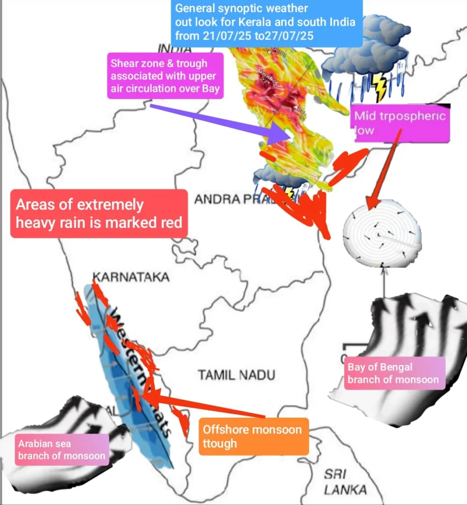
The northern monsoon trough currently runs through Rajasthan, Uttar Pradesh West Bengal with its south eastern extremity shifting south of its normal orientation north-west to south -east tilting south wards with height due to thermal gradient. The associated monsoon shear zone lies from north-western parts extending up to Jharkhand and the north – east.
An upper air circulation lies off the central Bay of Bengal which may move north- eastwards initially towards the head of Bay and gradually intensify into a monsoon depression heading westwards by 26 th July.
Due to the above conditions, extremely heavy rains may be expected Madhya Pradesh and adjoining south Uttar Pradesh The associated monsoon low embedded in the monsoon trough may propagate westwards through , Madhya Pradesh , east Rajasthan , west Rajasthan, between 27 th th & 28th July.
The offshore western monsoon trough may continue to remain active from Gujarat to Malabar.
The monsoon has been extremely vigorous over, Uttarakhand, Himachal Pradesh, Jharkhand, Madhya Pradesh, south eastern regions of Rajasthan, Uttar Pradesh, Bihar, gangetic west Bengal, Sub- Himalayan eest Bengal, Madhya Maharashtra, Konkan and Goa,and coastal Karnataka. The monsoon was very active & widespread in Odisha, coastal Maharashtra, and north & central Kerala and some pockets of south Kerala.
Rainfall has been isolated in J&K Andhra Pradesh, Telengana,and Tamil Nadu.
Monsoon performance
The monsoon continues to be on active mode with most of north India and south India recording normal to above normal rains. But with heavy deficit over 30% in the Arunachal Pradesh, Meghalaya, Assam, Sikkim Bihar in the north, in interior Maharashtra (Marathwada regions of Lathur, Aurangabad, Beed, Jalna, Osmanabad, Parbhani, Nanded & Hingoli), Rayalseema region of Andhrapradesh is worrisome.
In Kerala, as per available rainfall data from different sources , above normal rainfall has been recorded till date. There is high probability that a few high rainfall spots in Kannur(Iritty)/ Kozhikode ( Kakkayam)Wayanad( Mattilayam, Lakkidi)/Idukki( Kulamavu, Pettimudi, Peerumade)/ Kottayam(Poonjar, Piravom, Kuravilangadu) Pathanamthitta ( Athikkayam, Vadasserikara)may have already crossed 300 cms-350 cms of rainfall as on 20/07/25.
Prediction for the upcoming week from 21/7/25 to 27/7/25
KERALA
In view of the upper air circulation lying over central Bay of Bengal off Andhra coast and another one lying off the Mangaluru coast the offshore western monsoon trough would remain highly active with extremely heavy rains predicted for Kerala, from 23rd to 27th July , with the heaviest from 25 th to 27 th. This time central and south Kerala too would be impacted as the upper air circulation in the Bay may become a monsoon depression and move eastwards along central and northern India from 26 th to 28 th July.
High alert regions for extreme rains in Kerala from 23 rd July to 27 th July.
In Malabar region, very heavy rainfall may be expected in eastern pockets like Peravoor , Iritty, Mattannur, and Koothuparamba in Kannur, Punnakkal , Karulai ranges in Malappuram , Mananthavady, Lakkidi in Wayanad, Mannarkad ranges in Palakkad and on 26 th & 27 th July.
Coastal areas of Kasaragod, Kannur Kozhikode , Trichur and Ernakulam may also be impacted by moderate to heavy rains on 23 rd and 24 th July.
In central and southern Kerala, the eastern pockets of Ernakulam, Idukki and Kottayam may get extremely heavy rains on 23 rd and 24 th On 25 th & 26 th entire south Kerala would come in for heavy spells of rains, particularly Kollam and Thiruvananthapuram districts.
Eastern ranges in general and particularly, Malappuram & Mannarkad in Palakkad , Idukki need to be on high alert on 26 th & 27 th July for extremely heavy rains and possible landslides.
From July 30 th, rainfall intensity may decrease over Kerala which may continue into the beginning of August 2 nd week.
Temperature anomalies.
Most of the hill stations in Kerala may continue to remain rainy. Among the major hill stations in Kerala , Kanthalloor & Vattavada regions may experience the lowest maximum day temperature around 19 °C and a minimum of 16°C, followed by Munnar with a maximum day temperature of 23°C and a minimum of 17°C.
The other hill stations like Wayanad, ( Kalpetta, Vythiri, )Vagamon, Peerumade , Ponmudi, ( Thiruvananthapuram district )Painavu & Kumily lying at a lower altitude,( situated between 600 ms & 850 ms above msl) the maximum day temperature is likely to be around 25°C and minimum at 20°C.
In Wayanad, the high ranges of Meppadi, Sulthan Bathery, Ambalavayal located at a higher altitude of around 900 ms and above above msl, the maximum day temperature is likely to be 25°C and a minimum of 18°C.
The hillstations of Wayanad may be rainy on all days from 22nd to 28 th July.
In the lower plains of Kerala , the Malabar and central regions may experience a maximum day temperature of 29 °C – 31 °C and a minimum of 26°C and the south Kerala region , may get a maximum day temperature of 32°C and a minimum of 26°C.
Other regions
In Andhra Pradesh, & Telengana, extremely heavy rainfall is likely in Kakinada, Vizag, Vijayawada , Jagdalpur, Srikakulam and in Kurnool, Warangal , Khammam Ramagundam from 24th to & 26th July due to the upper air circulation over central Bay.
In Tamilnadu, the hill station of Ooty may expect wet weather with light to moderate showers throughout the week from 22 nd to 28 th July. the maximum day temperature is likely to be around 21°C and a minimum of 15°C in Ooty and in Kodaikanal, it would be 22°C and 14°C respectively with intermittent light rains from 22 nd th to 28 th July.
The upper shola regions of the these 2 hill stations, maximum day temperature could be lower at 18°C and a minimum of 13°C and may experience heavier rains.
In Valparai & Meghamala, it would be 25°C and 19°C respectively and in Yercaud and the Kolli hills, it would be 27°C & 18°C respectively . Heavy rains expected in Valparai on all days from.22 nd to 28 th July.
In Bengaluru & Mysuru intermittent spells of rains may be expected on 21st, 22 nd and 24 th July due to an upper air circulation over Andhra coast . The maximum day temperature in Bengaluru likely to be 27°C and a minimum of 20°C, while in the hill station of Coorg( Medikeri/ Kodagu) the maximum day temperature is likely to be 25°C and a minimum of 19°C.
In Tamil Nadu as an upper air circulation may lie over central Bay of Bengal, with the associated trough in the easterlies & due to moisture flux convergence , isolated moderate thundershowers may be expected in Puducherry, Vellore, Thiruvannamalai & suburbs of Chennai on 24 th July. Isolated thundershowers likely in Coimbatore, Pollachi and suburbs from 25 th to 28 th July.
North India & other other regions
For the upcoming week , due to active east- west monsoon shear zone and the upper air circulation embedded in monsoon trough lying over Haryana , extremely heavy rainfall is likely on 22 nd & 23 rd July in Chandigarh, Ludhiana, Patiala , Panipat in Haryana, NCR Delhi, Muzaffarnagar, Roorkee, Sharanpur in Uttar Pradesh, Shimla, Mandi, Nangal, Hamirpur, Chamba, Dharamsala in Himachal Pradesh , Nainital, Rampur, Ranikhet, Mukteshwar, Uttarkashi, Dehradun, Pauri in Uttrakhand.
The fresh monsoon depression may progress towards Jharkhand, east Uttar Pradesh, Madhya Pradesh from 24 th July from gangetic west Bengal , causing extremely heavy rains in the north- east, Kolkata , Kharagpur, sub- himalyan west Bengal, Dhanbad, Rourkela , Ranchi in Jharkhand, Purnia, Patna, Darbhanga in Bihar, from 24 th to 26 th July, Bhopal , Indore, Sagar & Jabalpur , Gwalior in Madhya Pradesh, Udaipur, Jaipur, Tonk, Dungarpur, Kota, in Rajasthan from 26th to 28 th July.
As the offshore western monsoon trough would remain fairly active from Gujarat to Malabar region, rainfall activity is likely to be widespread with moderate to heavy rainfall over entire coastal region of Maharashtra, and the ghats, Konkan & Goa, & Coastal Karnataka from 22 nd to 26 th July .
Extreme Rain Alert for north India
Extremely heavy rains may be expected in Gwalior, Indore , Bhopal, Sagar in Madhya Pradesh , Udaipur , Tonk, Bhilwara , Kota, Ratlam in Rajasthan, on 27 th & 28th July due to the monsoon depression moving westwards .
Kolkata, Bhuvaneswar, Gangtok, upper Assam, Darjeeling, Siliguri, on 24 th th & 25 th July.