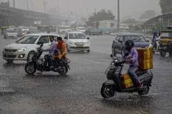
kerala weather 27/07/25: current heavy rains would become less intense from the 28 th of July
P. Reghu Ram
In order to come up with more relevant lead time prediction info so that stakeholders who might find it useful could take informed decisions , I am now trying to give an extended weekly update, which may effectively cover more than 7 days.
The northern monsoon trough currently runs slightly north at its north- west end through southern J&K, Rajasthan, Uttar Pradesh, West Bengal with its south eastern end tilting south wards with height due to thermal gradient. The associated monsoon shear zone lies from north-western parts extending upto Jharkhand and the north – east.
The mid -tropospheric monsoon depression lying over Rajasthan would unleash extremely heavy rains over south west Rajasthan, Ahmedabad , & Bhavnagar on 28 th July. Meanwhile with massive east- west monsoon shear zone embedded in monsoon trough bearing a lot of vorticity may facilitate a fresh monsoon low likely on 29 th over Jharkhand.
An upper air circulation may lie over Haryana and NCR Delhi on
29 th July which may trigger very heavy rains in west Uttarpradesh , Haryana and NCR Delhi, Pauri -Gharwal hills , Karnaprayag , Dehradun, Uttarkashi in Uttrakhand , between 28 th & 31 st July. The fresh monsoon low likely over Jharkhand and adjoining areas of gangetic west Bengal on 29 th July would cause very heavy rains over Kolkota, Burdhman and Kharagpur in West Bengal on 29 th July.
over Due to the above conditions, extremely heavy rains may be expected Madhya Pradesh and adjoining south Uttar Pradesh The associated monsoon low embedded in the monsoon trough may propagate further westwards through , Madhya Pradesh , east Rajasthan , west Rajasthan, between 27 th & 28th July.
The offshore western monsoon trough may continue to remain active from Gujarat to Malabar till 30 th July and thereafter it may weaken in sync with the northward shifting of the monsoon trough. A break in monsoon is likely from 30 th July till end of August first week as the rainfall intensity over central India may decrease drastically, while there would be a increase in rainfall activity in the north east.
The monsoon continues to be extremely vigorous over , Uttarakhand, Himachal Pradesh, Jharkhand, Madhya Pradesh, southeastern regions of Rajasthan, Uttar Pradesh, Bihar, gangetic west Bengal, north West Bengal, Madhya Maharashtra, Konkan and Goa,coastal Karnataka.
The monsoon was very active & vigorous over widespread in Odisha, coastal Maharashtra, north & central Kerala and some pockets of south Kerala. In Kerala extensive flooding has been reported in many places in Kannur, Kozhikode, Wayanad and in Ernakulam and Idukki districts as many rivers burst their banks inundating vast swaths of low lying areas. Rainfall has been isolated in Assam, Bihar & Andhra Pradesh, & widespread over Telengana.
Monsoon performance
The monsoon continues to be active in most of north and western India . As on date, the deficit rainfall in Arunachal Pradesh, Meghalaya, Assam & Bihar stood above 40% and in Sikkim, Manipur, east Uttar Pradesh & NCR Delhi it was 32%, 21% , 21% & 21% respectively in the north. In central India, the Marathwada region in interior Maharashtra with a deficit of 25% and in the south the Rayalseema region of Andhrapradesh with 21% deficit might make up the shortfall in the ensuing weeks.
In Kerala, as per currently available rainfall data from different sources , above normal rainfall has been recorded till date. As per data collected and shared by the Wayanad based NGO, Hume Centre for Ecology & Wildlife biology, Kalpetta, Mattilayam in Wayanad has logged the highest rainfall in Kerala with a massive 4439 mm, followed by Niravilpuzha (3729 mm), Lakkidi (3616 mm), and Kappikkalam (3517 mm).
However as I had pointed out in my last week’s analysis, there could be other very high rainfall potential hotspots like, Kakkayam, Kuttiyadi ( Kozhikode ) , Irikkur , Iritty( Kannur) Kudlu, Vellarikund (Kasaragod ), Walakkad ( Palakkad), Neriyamangalam ranges( Ernakulam), Vadasserikara, Athikkayam, Kakki(Pathanamthitta) Peerumade, Kulamavu, Pettimudi ( Idukki). But lack of streamlined uniformly gridded data is an issue.
Prediction for the upcoming 2 weeks from 28/07/25 to 10/08/25
KERALA
The current heavy rains would become less intense from the 28 th of July as the northern monsoon trough is likely to shift north and in sync with this the western offshore monsoon trough may also weaken. This break phase may remain till the end of August first week. This would cause a drastic decrease in monsoon activity in central India, while an increase in monsoon rainfall activity is likely over the north-east & Uttrakhand.
Meanwhile, a moderately strong westward moving Rossby wave activity over south Indian Ocean could trigger an upper air circulation and associated low over north-east off Srilanka from 5 th August.
This would cause heavy thunder showers mainly in Tamilnadu, interior Karnataka, and eastern ranges of Kerala from 5 th to 8 th August. As a north- south shear zone may lie from north interior Karnataka to south Tamil Nadu, most of the heavy rainfall activity would be in the belt extending from Bellari in interior Karnataka to Salem in interior Tamilnadu. Naturally, pockets like Bangluru, Mysuru, Erode, Salem and adjoining areas would come in for heavy spells on 7 th & 8 th August.
In Kerala, though monsoon rains may decrease, heavy thundershowers may be expected in eastern pockets in Idukki and Wayanad from 6 to 8 th August with chances of extremely heavy thunder showers on 8 th & 9 th in Idukki and eastern pockets of Ernakulam & Kottayam.
High alert regions for extreme rains in Kerala from 28 thJuly to 10th August 2025.
In Malabar region, very heavy rainfall may be expected in eastern pockets like Peravoor , Iritty, Mattannur, and in Kannur eastern pockets of Kasaragod , Mananthavady, Lakkidi, Vythiri in Wayanad, Punnakkal, Karulai in Malappuram from 6 th to 9 th August. In central and southern Kerala, the eastern pockets of eastern ranges of Ernakulam, Kottayam & Idukki may get extremely heavy rains on 6 th, ,8 th & 9 th August.
Heavy rainfall alert for other regions
North India
In north India, the mid tropospheric monsoon depression embedded in the monsoon trough currently lying over west Madhya Pradesh and adjoining areas of Rajasthan may cause extremely heavy rains in Udaipur, Kota, Ajmer, Bhilwara & Jaipur in Rajasthan on 28 th July, Bhopal, Lalitpur, Guna in Madhya Pradesh , Bareilly, Moradabad, Sharanpur in Uttar Pradesh, Dehradun, Uttarkashi, Pauri Gharwal in Uttrakhand , Kolkata , Bardman , Kharagpur on 28 th & 29 th, Dhanbad, Ranchi, Jamshedpur in Jharkhand on 29 th, NCR Delhi, Agra, Gwalior on 30 th & 31 st July.
Extremely heavy rains may be expected in the foot hills of Himalayas and in Uttrakhand region particularly in Dehradun, Uttarkashi, Pauri Gharwal, Ranikhet, Bageswar, Karnaprayag , Mussoorie, Dhanolti, Chakratha on 28 th 29 th July and on 6 th & 7 th August, and in Dharamshala, Chamba, Rampur Mandi and Kullu in Himachal Pradesh on 29 th & 30 th July.
North eastern region
As there would be a break in monsoon from 30 th July to 10 th August, with the northern monsoon trough shifting north to the Himalayas, heavy rains are likely in the north eastern region of upper Assam, Meghalaya and. sub- Himalayan west Bengal regions of Darjeeling, Siliguri, Alipurduar, Sikkim from 3 rd August to 9th August.
Due to an upper air circulation which is likely to lie over south Bay of Bengal from 5 th August and a north – south shear zone extending from north interior Karnataka to south interior Tamilnadu, very heavy rains may be expected in Hubballi, Bengaluru, Kunigal, Hindupur Mysuru , Erode, Namakkal on 7th , 8 th & 9 th August.
Temperature anomalies
Most of the hill stations in Kerala may continue to remain overcast and generally without much rain from 28 th till 6th July. From 6 th however the hill stations may get heavy thundershowers which is technically not monsoon rains.
Among the major hill stations in Kerala , Kanthalloor & Vattavada regions may continue to experience the lowest maximum day temperature around 19 °C – 20 °C and a minimum of 16°C, followed by Munnar with a maximum day temperature of 23°C and a minimum of 16°C.
The other hill stations like Wayanad, ( Kalpetta, Vythiri, )Vagamon, Peerumade , Ponmudi, ( Thiruvananthapuram district )Painavu & Kumily lying at a lower altitude,( situated between 600 ms & 850 ms above msl) the maximum day temperature is likely to be around 26°C and minimum at 19°C.
In Wayanad, the high ranges of Meppadi, Sulthan Bathery, Ambalavayal located at a higher altitude of around 900 ms and above above msl, the maximum day temperature is likely to be 25°C and a minimum of 19°C. The hillstations of Wayanad may be rainy on all days from 6 th to 9 th July.
In the lower plains of Kerala , the Malabar and central regions may experience a maximum day temperature of 29 °C – 30 °C and a minimum of 26°C and the south Kerala region , may get a maximum day temperature of 32°C and a minimum of 26°C.
Other regions
ANDHRAPRADESH & TELENGANA
In Andhra Pradesh, & Telengana, moderate to heavy rainfall is likely in Thirupathi, Vijayawada on 6 th August, Hyderabad, Mehbubnagar on 9 th August. July due to the upper air circulation over south central Bay.
KARNATAKA REGION
Due to the upper air circulation over south central Bay, in Karnataka, heavy thundershowers may be expected in Bengaluru, Mysuru , Tumkur, Hindupur, Kunigal & Hubballi on 7 & 8 th August, Hubballi, Devanagare, Shivamogga on 9th August.
TAMIL NADU REGION
In Tamilnadu, the hill station of Ooty may expect overcast sky from 28 th to 2 nd August . Thereafter light to moderate intermittent showers likely from 4 th to 10 th August . The maximum day temperature is likely to be around 20°C and a minimum of 15°C in Ooty and in Kodaikanal, it would be 21°C and 14°C respectively with intermittent light rains from 5 th to 9 th August with most of the rains falling between 5 pm & 8 pm.
The upper shola regions of the these 2 hill stations, maximum day temperature could be lower at 18°C and a minimum of 13°C and may experience heavier rains.
In Valparai & Meghamala, it would be 24°C and 19°C respectively and in Yercaud and the Kolli hills, it would be 28°C & 19°C respectively . Heavy rains expected in Valparai on all days from.22 nd to 28 th July.
The maximum day temperature in Bengaluru likely to be 28°C and a minimum of 20°C, while in the hill station of Coorg( Medikeri/ Kodagu) the maximum day temperature is likely to be 24°C and a minimum of 19°C.
In Tamil Nadu thanks to the upper air circulation over south- central Bay of Bengal, with the associated trough in the easterlies & due to moisture flux convergence , isolated moderate thundershowers may be expected in Madhurai , Bodi Theni , Puducherry, Vellore, Thiruvannamalai 5 th August , Rajapalayam, Tenkasi, Manjolai hills, Thoothukudi on 6 th, 7 th & ,9 th August.
Tag:Stay updated with the latest UAE weather forecast for July 26, 2025, and essential safety tips. Monsoon break expected from July 30 to early August.