
Heavy Rain Ahead, Monsoon remained fairly active Kerala and Other states
Kerala weekly weather update from 14/07/25 to 20/07/25
Current observations
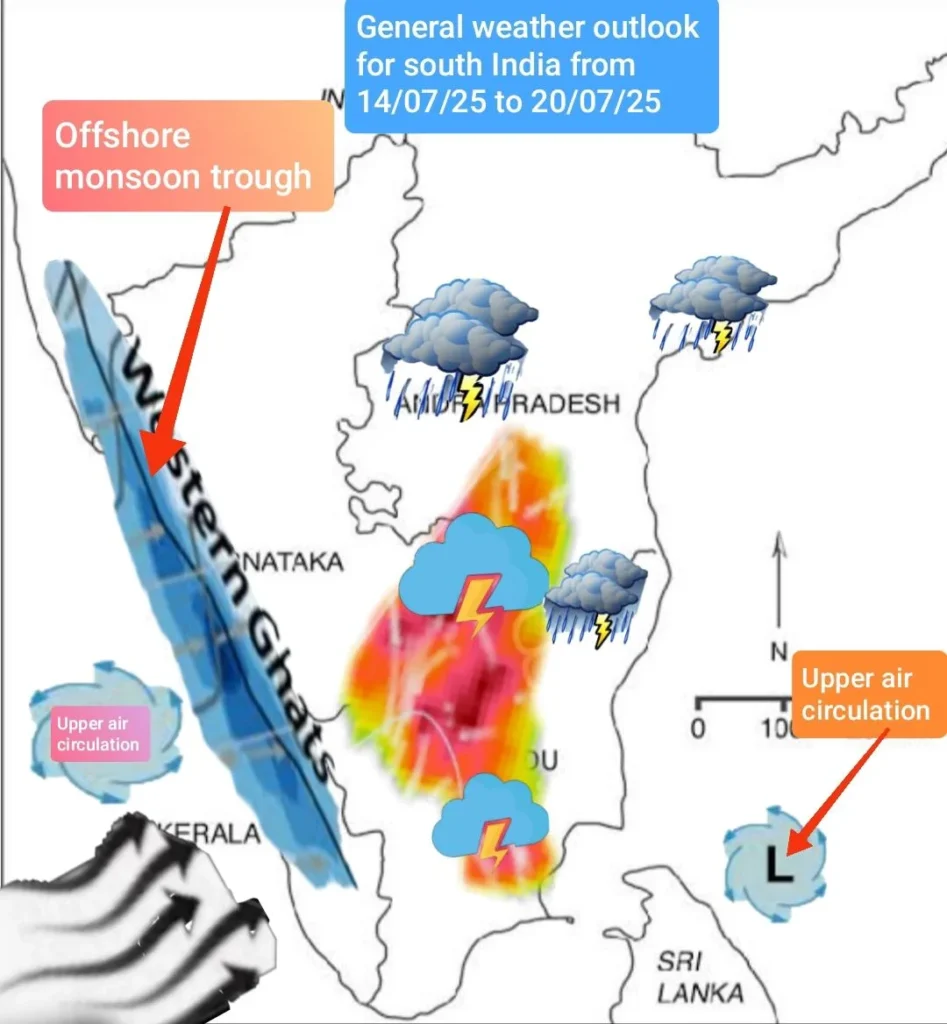
The northern monsoon trough lies south of its normal orientation north-west to south – east from west Rajasthan to west Bengal and dipping into the Bay tilting south wards with height due to thermal gradient. The associated monsoon shear zone may lie from north-western parts extending upto Jharkhand.
An upper air circulation is over Madhya Pradesh and adjoining south Uttar Pradesh The associated monsoon low embedded in the monsoon trough may propagate westwards through , Madhya Pradesh , east Rajasthan , west Rajasthan, between 14 th & 16 th July.
Meanwhile, a fresh low is likely to develop off the Andhra Pradesh coast around 18 th – 20 th July.
The offshore western monsoon trough may remain active from Gujarat to north Malabar.
The monsoon continues to be extremely vigorous over, Uttarakhand, Himachal Pradesh, Jharkhand, Madhya Pradesh, southeastern regions of Rajasthan, gangetic west Bengal, Sub- Himalayan eest Bengal, Madhya Maharashtra, Konkan and Goa, some parts of Arunachal Pradesh and upper Assam.
Monsoon remained fairly active & widespread in Odisha, coastal Maharashtra, coastal Karnataka and north Kerala.
Rainfall has been isolated in J&K Andhra Pradesh, Telengana, & Bihar. As usual generally dry weather prevailed in Tamilnadu except isolated regions like west Nilgiris, Valparai and Manjolai hills in Thirunelveli district adjoining the windward western flanks of the western ghats.
Maximum day temperature too rose to above 40 °C in Madhurai and certain interior pockets of Tamil Nadu due to higher adiabatic compression rate of the leeward winds and more dryness.
Monsoon performance
The monsoon continues to be performing near normal over most of north India and south India as on date has been nearly normal for the whole country but with heavy deficiency over 30% in the north – east, Bihar, and interior Maharashtra (Marathwada regions of Lathur, Aurangabad, Beed, Jalna, Osmanabad, Parbhani, Nanded & Hingoli).
In Kerala, rainfall data is not centralized and uniform with various agencies recording different data for the same period. However when compiling and collating all these data what is revealed is that above normal rainfall has been logged in Kerala till date.
Prediction for the upcoming week from 14/7/25 to 20/7/25.
KERALA
In Kerala, moderate to heavy rainfall activity is likely in Kasaragod, Kannur & Kozhikode, Malappuram, Palakkad, and Trichur regions from 14 th to 20th July as the offshore monsoon trough is active along with a mid tropospheric cyclone in the form of an upper air circulation that may lie over the north Malabar coast.
Moderate rains may be expected in central Kerala. The rains would be heavier on 16 th,17 th 19 th & 20 th July in coastal Malabar regions and the eastern pockets of Kannur, Kozhikode, Malappuram, Palakkad, Trichur , Ernakulam , Idukki and Kottayam & Pathanamthitta districts.
Moderate rains may be expected in Kollam & Thiruvananthapuram districts from 18 th to 20 th July.
Though there is no alert for any likelihood of extremely heavy rains in any district in Kerala for the upcoming week, the monsoon may not get any break and it may remain fairly active continuously over Kerala with moderate activity till the end of July.

Temperature anomalies
Most of the hill stations in Kerala may remain rainy. Among the major hill stations in Kerala , Kanthalloor & Vattavada regions may experience the lowest maximum day temperature around 19 °C and a minimum of 16°C, followed by Munnar with a maximum day temperature of 23°C and a minimum of 17°C.
The other hill stations like Wayanad, (Kalpetta, Vythiri) Vagamon, Peerumade , Ponmudi, ( Thiruvananthapuram district ) Painavu & Kumily lying at a lower altitude, ( situated between 600 ms & 850 ms above msl) the maximum day temperature is likely to be around 26°C and minimum at 21°C. In Wayanad, the high ranges of Meppadi, Sulthan Bathery, Ambalavayal located at a higher altitude of around 900 ms and above above msl, the maximum day temperature is likely to be 25°C and a minimum of 18°C.
The hillstations of Wayanad may be rainy on all days from 15th to 20 th July. In the lower plains of Kerala, the Malabar and central regions may experience a maximum day temperature of 29 °C – 30°C and a minimum of 25°C and the south Kerala region, may get a maximum day temperature of 32°C and a minimum of 26°C.
Other regions
In Telengana and Andhra Pradesh, moderate to heavy rainfall is likely in Kakinada, Vizag, Vijayawada Srikakulam and in Kurnool Warangal Ramagundam on 17 th & 18 th July.
In Tamilnadu, in the hill station of Ooty , expect rainy weather on 16 th 19 th & 20 & the maximum day temperature is likely to be around 21°C and a minimum of 15°C in Ooty and in Kodaikanal, it would be 21°C and 16°C respectively with moderate rains from 16 th to 20 th July.
The upper shola regions of the these 2 hill stations, maximum day temperature could be lower at 18°C and a minimum of 13°C and may experience heavier rains.
In Valparai & Meghamala, it would be 25°C and 19°C respectively and in Yercaud and the Kolli hills, it would be 27°C & 18°C respectively , with heavy rains expected in Valparai on all days from.15 th to 20 th July.
In Bengaluru & Mysuru intermittent spells of rains may be expected on all days from 16 th to 20 th due to an upper air circulation over Malabar coast and another one over south Bay of Bengal. The maximum day temperature in Bengaluru likely to be 26°C and a minimum of 20°C, while in the hill station of Coorg ( Medikeri / Kodagu ) the maximum day temperature is likely to be 25°C and a minimum of 18°C.
North India and Other Region
In Tamil Nadu as an upper air circulation may lie over south Bay of Bengal, with the associated trough in the easterlies & due to moisture flux convergence , isolated heavy thundershowers may be expected in Madhurai, Dindigul,Puducherry, Vellore, Thiruvannamalai, Pudukkottai on 16th and 17th July.
Isolated thundershowers likely in Chennai and suburbs towards late evening or late night on 17 th July.
North India & other other regions
For the upcoming week , due to the upper air circulation embedded in monsoon trough lying over Madhya Pradesh and with another low over Bihar.
very heavy rainfall is likely in Bhopal, Indore, Sagar & Jabalpur in Madhya Pradesh , Udaipur, Jaipur, Tonk, Dungarpur, Kota, in Rajasthan, NCR Delhi, Chandigarh, Panipat, Hisar in Haryana, Dahod, Vadodaara, Khambat in Gujarat , Agra, Jhansi Bareilly in Uttar Pradesh, Nangal, Mandi, Solan, Chamba , Shimla & Hamirpur in Himachal Pradesh on 14 th & 15 th July, Dhanbad, Rourkela, Ranchi in Jharkhand, Purnia, Patna, Gaya in Bihar,Kolkotta, Darjeeling , Siliguri, Kalimpong, Alipurduar in West Bengal from 15 th to 17 th July.
Prayagraj, Varanasi, Kanpur, Lucknow , Fatehpur and Agra in Uttar Pradesh on 17 &18 th July, & the north – east from 15 th to 18th July.
As the offshore western monsoon trough would remain fairly active from Gujarat to Malabar region, rainfall activity is likely to be widespread with moderate to heavy rainfall over entire coastal region of Maharashtra, and the ghats, Konkan & Goa, & Coastal Karnataka from 14 th to 20 th July.
Extreme Rain Alert
Extremely heavy rains may be expected in Gwalior, Bhopal, Sagar in Madhya Pradesh , Jaipur , Tonk, Bhilwara , Kota, Ratlam in Rajasthan, on 14th & 15 th July due to the monsoon depression moving westwards.
Kolkata, Bhuvaneswar, Gangtok, Darjeeling, Siliguri on 14 th & 15 th July. Fresh monsoon depression is likely around last week of July over head Bay of Bengal.
Global weather outlook for the upcoming week
High day temperature may continue over on western Europe with the dominant Azores high shifting eastwards while ridging may continue to trap heat over North western USA, the Carribbean region, and southern parts of USA.
Last week’s Omega blocking has drifted apart, but ridging is persistent over north western USA. Storm tracks and large scale shear zone propagating from Ontario in Canada and moving south eastwards through Minnesota and central USA would cause heavy precipitation in Minnesota , Kansas city on 18 th & 19 th July.
As the NAO ( North Atlantic Oscillation) is currently in a negative phase which means the pressure gradient between Azores high and Icelandic low in the Atlantic is less pronounced, it causes the westerly jet to be more wavy and hence bring troughlines with more warmer air and storm tracks to southern Europe and drier & cooler air towards northern Europe and the Scandinavian countries.
In the global tropics, the MJO is non- descript, incoherent and is hanging around its Phase-5.Large scale wave-1 pattern and equatorial Kelvin wave seem to be driving cyclonic circulations in the tropics.
Anomalous upper leave easterlies have strengthened over tropical Indian Ocean which can enhance monsoon level troughs and hence more wet weather to follow in east Asian monsoon regions.
Summary : Stay informed about the heavy rain forecast as the monsoon remains active in Kerala and other states. Get the latest updates and safety tips here.