
how weather around us this week? know more
P. Reghu Ram
kerala weekly weather update from 01/07/25 to 06/07/25

Hi dear readers, my thanks are due to the Metbeat team for having given me an opportunity to run a weekly, Kerala-specific feature on weather on this website.
Monsoon performance
After an early onset in Kerala the monsoon has performed almost normal in Kerala with the departure from normal values well within the 1% – 15% range based on district wise long period average.
As on 30/6/25, based on data given by volunteer groups in Kerala like Malappuram Rain trackers, Hume Centre for Ecology and Wild Life Biology , Wayanad and pvt individuals dedicated to compilation & tracking rainfall, Mattilayam in Wayanad tops the list of heavy rainfall stations with 268.5 cms followed by Lakkidi in Wayanad with 238 cms and Niravalpuzha in Wayanad with 231 cms.
However, the above data may not be upto date due to Insufficient or no data from the other usual very heavy rainfall stations of the following districts in Kerala : Kasaragod, ( Malom, Nelliketta,Vellarikund), Kannur ( Koothuparamba, Iritti, Ayyankunnu, Irikkur) eastern pockets in Kozhikode ( Vadakara, Kuttiyadi, Kakkayam) , Malappuram ( Edavanna, Kalkundu) Idukki( Elappara, Peerumade) , Palakkad ( Kumaramputhur, Walakkad in Silent Valley), Thrissur ( Poringalkuthu, upper Sholayar dam), Ernakulam (Neriyamangalam) & Kottayam ( Vayala, Poonjar-Erattupetta, Kozha).
Thiruvananthapuram brought up the rear with the lowest rainfall of just 30 cms till 30/6/25 which is normal for the station. Some stations on the leeward rainshadow side of Munnar like Marayur, Vattavada and Kanthalloor also received much less rainfall during this period which is also normal. Going by district wise long period average rainfall, Palakkad, Thrissur, Kannur, & Pathanamthitta received above normal rainfall as on 30/06/25.
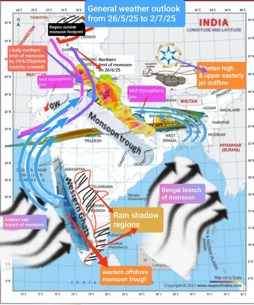
As regards the country, the monsoon covered the entire country on 29/6/25 , exactly as I had predicted on 26/6/25 in my weekly fb post published on 26/6/25.(Please see pic below from the fb post ).
Forecast for this week
For the upcoming week , as the offshore western monsoon trough is active from Gujarat to Malabar region rainfall activity in Kerala would continue but with lesser intensity . Most of the rainfall activity would be in eastern pockets of Kannur and Kozhikode between 2 nd & 4 th July and in eastern pockets of Kottayam and Pathanamthitta on 2nd & 3 rd July.
Due to local moisture flux convergence and easterly trough anomalies, the rains in eastern pockets of Thiruvananthapuram, Kollam, Pathanamthitta, Idukki and Palakkad between 2 nd & 6 th July may be accompanied by thunderstorm activity.
Another Monsoon Low Ahead
Another mid tropospheric monsoon low has developed near the head of Bengal Bay.The northern monsoon trough may lie north- west to south – east with its southern extremity more tilted to the south with height.Hence widespread heavy rainfall may occur over NCR Delhi and Haryana on 30 th June & 1st July, west Uttar Pradesh, east Rajasthan, Madhya Pradesh , interior Maharashtra, from 3 nd to 6 th July Extreme heavy rains should be expected in Bhopal, Indore, and pockets like Udaipur in south Rajasthan from 4 th to 6 th July.
( Author : P. Reghu Ram, senior
Freelance weather analyst )